CHAPTER V PHYSICAL ENVIRONMENT IN THE PALMYRA BASIN
Masami FUKUDA
Department of Geography, Faculty of Science, The University of Tokyo
1. CLIMATE OF SYRIAThe climate of Syria is marked by a rainy winter and a prolonged dry summer, which is so-called "Mediterranean climate". Almost rainfall in winter over the general region of western Asia originates in cyclonic storms which cross the area from west to east. In the case of Syria, the coastal regions are greatly affected by the cyclonic activities from the Mediterranean. Inland region of the western Asia, the effects of cyclonic activities decrease west to east and north to south. Thus, inland on Syria has small amount of annual precipitation (Fig. V-1). The rain-bringing cyclones from the Mediterranean have a few restricted tracks passing through the western Asia, and these tracks are controlled by the seasonal shifting of the Eurasian polar frontal zone (Yoshimura, 1967, de Brichambaut and Wallen, 1968). In summer, the Eurasian polar frontal zone shifts to the north and locates nearly in 30°~40° N latitude. In the southern side of frontal zone, the stable subtropical high pressure develops over the Mediterranean. Thus, Syria is covered by this high pressure and hot and dry climate prolongs during a few months in summer. In winter, the Eurasian polar frontal zone has a few branches, such as the Mediterranean branch, which has a maximum frequency from January to March. The rain-bringing cyclones move along a few tracks within the Mediterranean branch of polar frontal zone. These cyclones are called by the Indian meteorogists as western degression or northwesterly disturbance. By the two different tracks of the cyclones, the cyclones are classified into two types (de Brichambaut and Wallen, 1968). The first type is originated by the shallow wave moving in the upper troposhere jet stream, and its speed of moving is rather rapid. The main tracks of this type are in northern side of the western Asia, along the mountain ranges of Turkey, or in northern Lebanon and Syria. Occasionally, this cyclone brings heavy rainfall on the wind-ward side of Zagrous mountains. The cyclones mainly occur in winter. The second type of the cyclone generates from the cold troughs in upper air on the Mediterranean, and is rather stationary adjacent to the Cyprus. After passing slowly over the Lebanon and Anti-Lebanon mountains, it remains stationary over the semi-arid zone of Syria and Jordan. The south-westerly and north-westerly caused by the passing of the cyclone bring heavy rain to Lebanon, Syria, and northern Jordan. And through the low lands of Iraq, humid and warm air masses from the Persian Gulf are drawn to this stationary cyclone. This humid and warm air stream causes the orographic rainfall over the mountaineous regions of Iraq. This type of cyclone mainly occur in late winter and early spring. Almost the cold high pressure from continental polar zone shifts down to the south in winter. This polar high pressure cell causes the severe cold weather in winter over whole western Asia.
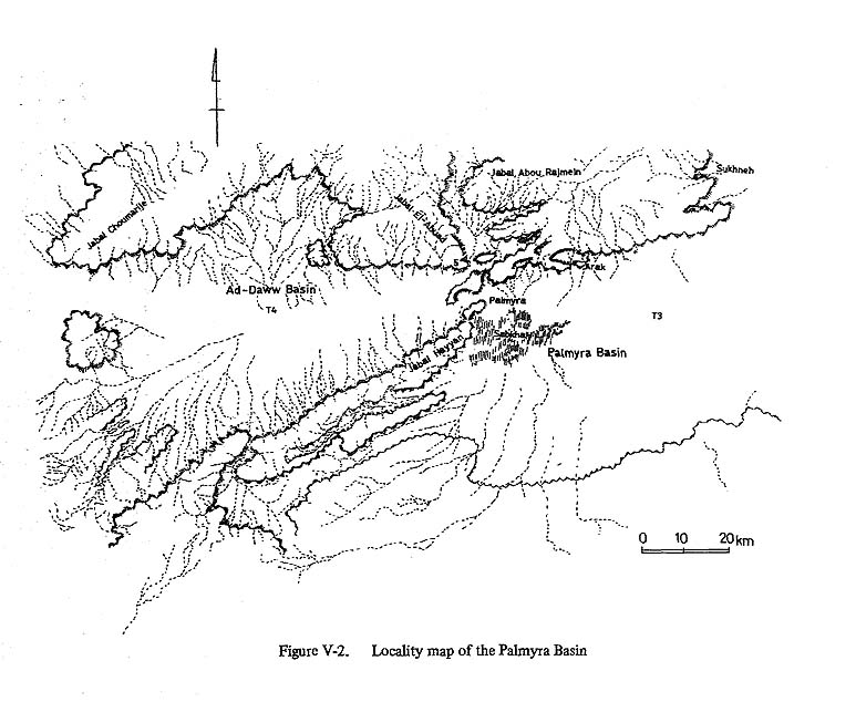
2. OUTLINE OF THE PALMYRA BASINThe Palmyra Basin is located in the middle to northern parts of the Syrian desert. It is an inland basin, bounded in the north and west by the Palmyrides, and on the south by the basalt-covered, main table plateau of the Arabian Peninsula (Fig. V-2). The Palmyrides mountain ridges run ENE en echelon from Damascus on the west to the Euphrates on the east. The plateau becomes lower to the east and extends uninterrupted to the higher terrace of the Euphrates.
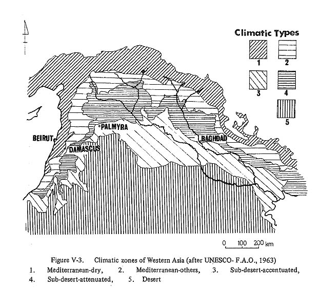
The Palmyra Basin belongs to the subdesert climatic zone (Fig. V-3), consequently, the vegetation cover is poor except at sporadic oases like Palmyra Village. Precipitation comes mostly during the rather short period in winter, and surface water flows only intermittently through poorly developed river channels. Water is not drained out of the basin through a temporal valley system or wadi, and accumulations of water in the central area of the basin form a small scale lake. However, summer drought makes the lake water evaporate, and the lake exists only during a short period in the winter season.
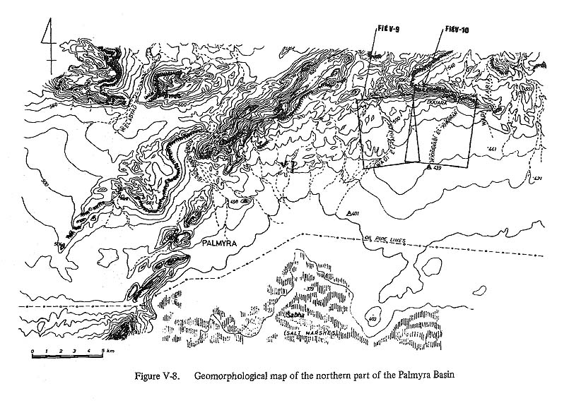
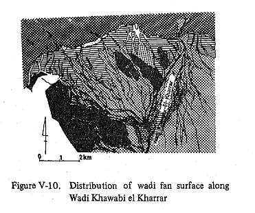
Adjacent to the Palmyra Basin, there are a few small basins of similar genesis and character, such as ad-Daww Basin to the west. The formation of the basins is related to the upheaval and formation of the Palmyrides during the Palaeogene. Talus, wadi fans, wadis, Sabha and Nebka, land forms distinctive ot arid zones and pluvial zones ot the Upper Pleistocene, are well distributed in the Palmyra Basin (Figs. V-8, 9, 10, 11, 12). These land forms will be discussed with particular reference to the reconstruction of the palaeogeography as it is related to human activity in the Palmyra Basin during and since the Upper Pleistocene.
3. THE MOUNTAIN SLOPE DEVELOPMENT AND TALUS DEPOSITS SURROUNDING THE PALMYRA BASINThe mountains surrounding the Palmyra Basin consist of a bedrock of dense limestone containing flint of Palaeogene age and a sandy or chalky limestone of Pliocene age (Ponikarov, et al., 1963). The development of erosional land forms in the mountains and alluvial land forms in the wadi fans is greatly influenced by the processes of the weathering of the limestone bedrock under different climatic conditions in the past and the present. Talus deposits or cones at the foot of mountain cliffs or steep slopes are the most distinctive products of limestone weathering. They are composed of angular boulders and pebbles derived from upper part of the slopes or cliffs, where the active exfoliation of the bedrock goes on (Pl. V-1a). Under arid conditions deflation and isolation are the most typical kinds of weathering (Glennie, 1970). However, surface water is a more significant erosional agent in the Palmyra Basin than in the more arid zones in the Arabian Peninsula.
Daily temperature fluctuations and wet-dry cycles cause destruction (both by exfoliation and isolation) of rocks. According to our observations, the maximum surface temperature of the limestone bedrock in August is 55°~60° and the minimum is 10°~12°. The range of this temperature fluctuation is rather large and causes differential thermal expansion of grains of the rock. But thermal strain of grains is not enough to cause disintegration. Schumm and Chorley (1968) suggested that the wet-dry cycle also plays an important role in the disintegration of rocks in arid zones. During wet conditions, rocks are dissolved into ionic forms and suspensions by pore water rich in C2 (PI. V-1, b). In Palmyra we observed salt concentrations in the sediments. These salts are water solution products. Figure V-4 shows the relative salinity of various sediments. In the center of Sabha, high concentrations of salt were observed, and even on the surface of the wadi channels a rather high concentration of salt was observed. These materials are provided at first as salt-rich water, and they are concentrated to the uppermost part of the sediments by the dry an wet cycles. Thermal expansion of the salt and crystalization of salt from solution in cracks in the rocks play important roles in the disintegration of the bedrock into boulders and pebbles or finer materials. This weathering process is known as salt weathering (Bruckner, 1966).
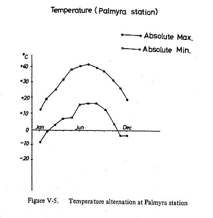
The most important agent in the disintegration of the bedrock is the temperature fluctuation during the winter rainy season when the absolute minimum temperature at Palmyra reaches minus 6°~8° (Fig. V-5) and the bedrock is saturated by water because of the increased rainfall. The water in the pores of the rocks alternately freezes and thaws. In limestone, if the pores are fully saturated by water, the rock is quite sensitive to frost action (Quillen and Lautridou, 1970; Lautridou, 1971). A frost action test of the limestones from Douara Cave was carried out in a cold chamber of the Low Temperature Science Institute of Hokkaido University. After 20 cycles of daily freezing and thawing between ±10°C and -15°C, the samples were about 2-5% disintegrated into small particles, and the induced frost action produced sharp edged pebbles similar to those in the talus deposits near Douara Cave. The results of this experiment cannot be applied directly to phenomena observed in the field, but they suggest the processes of bedrock weathering in cold, humid environments. Talus deposits and cones at the foot of mountain slopes might be explained by this process of exfoliation. If the environment is colder and more humid, the production of boulders and pebbles by frost action is more active (Wirth, 1958). Notable in this respect is the fact that the altitudinal lower limits of periglacial conditions during last glaciation might have been as low as +850m in the Palmyra region (Kaiser, 1969). Other evidence to support extensive frost action is given by Abdul-Salam (1965) and Nir (1963). It seems in recent environment that the talus deposits on the slopes of the Palmyrides were produced mainly by the wet-dry cycle, salt weathering and frost action, while during last glaciation (Würm) frost action might have been the most significant.
4. WADIS AND WADI FANSIn the Palmyra Basin, a number of fan-like land forms spread out from the slopes of the Palmyrides toward the central, flat area of the basin. These formations are called wadi fans (Glennie, 1970) or inland deltas (Holn, 1960). The apexes of the wadi fans are located against the mountain slopes. Wadi channels develop on the fan surface in braided distributory patterns such as are commonly seen on alluvial fans in more humid climates. Water flow in the wadis is not permanent and is supplied mostly by the sporadic rainfall on the mountains and plateaus during the short winter rainy season. Storms occasionally bring too much water to be drained through wadi channels, and most of the water overflows the channels and flows down the surface of fans as a type of sheetflood. These floods probably create the micro-relief observed on the fan surfaces (Fig. V-6). These formations are similar to the flood-caused micro-relief formations on slopes in the Jordan Valley (Finzi, 1964).
The wadi flow has considerable force for a short distance near the apex of fan. This is reflected in the sedimentary facies of fan sediments, which are similar to the mudflow deposits. The sediments consist of conglomerates with a fine matrix and are poorly sorted. The velocity of flow drops rapidly after a short distance because of infiltration into the sediments and reduction in the volume of water. Another important character of fan sediments is their early cementation caused by precipitation of calcium carbonate and removal of capillary water during the summer drought. This hardening of the deposits makes the fixing of the wadi channel beds rather rapid.Consequently, the profile shows a lot of nick points (Fig, V-7). The fans have bench surfaces resembling river terraces. These surfaces can be correlated by means of their relative heights, if each surface development of the same elevation is assumed to be a synchronous occurrence. Blissenbach (1954) noted some terracing of alluvial fan surfaces in arid zones, and geologists of the U.S.S.R. classified the fan deposits in the Syrian desert into 4 groups by stratigraphic correlations.
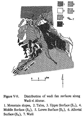
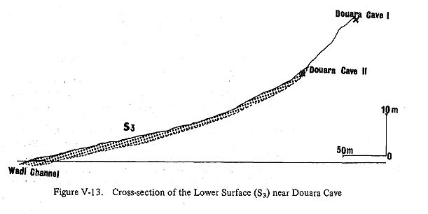
In the Palmyra Basin we classified the fan surfaces into 4 groups on the basis of evidence from photo-interpretation and field investigation. The surfaces are caklled Upper surface (S1), Middle surface (S2), Lower surface (S3) and Alluvial surface (S4), without strict significance to their genesis. These terraced surfaces developed differently, under different environments and in different geologic periods. They are described below from the highest (S1) to the lowest (S4), in the order of their formation (Figs. V-8, 9,10,11,12). 1) Upper Surface S1The highest surface(S1) is distributed mainly in a narrow area on the right side of Wadi el Ahmar. It forms remnant hillocks. Its deposits are a conglomerate consisting mainly of subangular boulders and pebbles with an abundant fine matrix. The sorting of the conglomerates is poor, but the pebbles and cobbles have an imbricated structure to some extent. The thickness of deposits might be within 10-15m, although the base of the deposits could not be observed. It becomes gradually thinner toward the apex and in parts near the mountain slope where the conglomerate directly covers the limestone bedrock. Gravels with desert varnish and rounded edges are scattered on the surface. The sediments are strongly bonded by cementation, but sandy lenses are rather loose. Remarkable lateralization is observed at the parts of sandy lenses along the surface. This deposition suggests a prevalence of fluviatile transportation. 2) Middle Surface :S2This surface is distributed widely along both sides of Wadi el Ahmar. The apex of its fan near the mountain slopes is covered with recent talus deposits. The fan is gently rolling. There are distinctly dissections. Lateral erosion has revealed all sections of the sediments of this surface along the main wadi channel. The sediments are about 5m thick, cover directly the limestone bedrock. Its surface is about 16 m above the wadi bed at an elevation of 480m above sea level. The sediments are conglomerates of pebbles and boulders and not well sorted. The sedimentary facies is similar to a mudflow but with less matrix. The surface gradient is steeper than that of the Upper surface but less than the right side of Wadi Khawabi el Kharrar, S2 remains as eroded remnant hillocks. The apex of the fan is eroded out. According to geologists from the U.S.S.R., this surface may be correlated with the 3rd terrace of Euphrates River. It contains flint tools which possibly belong to Middle Palaeolithic. 3) Lower Surface :S3Lower surface S3 is the fan, which spreads most widely among the fans and it continues along the southern slopes of the Palmyrides between Damascus and Palmyra. In the Palmyra Basin, the surface is seen typically between Wadi el Ahmar and Wadi Khawabi el Kharrar. The distribution of this surface along Wadi el Ahmar is shown in Figure V-13.
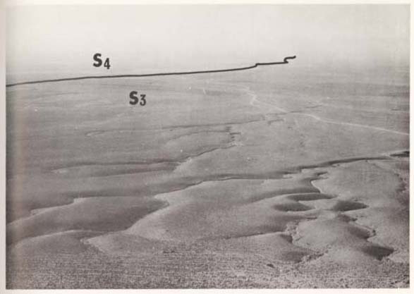
The height of the surface from the wadi channel is about 6-10 m, and the thickness of the gravel layer is within 5-8 m. The deposits consist of alternations of sand and conglomerates. The lower part of the bed is composed of subrounded pebbles and has an imbricated structure. The upper part of the beds is badly sorted. The boulders in the conglomerates become more angular from bottom to top. The sequence of sediments indicates that the lower levels were deposited under more fluviatile conditions. From the center of the fan to the margins, the sediments become thinner. The outer edge of the S3 is invisible, covered with the alluvial sediments of flat plain which is defined as S4 in this paper. This surface covers Jerf Ajla Cave (Shroeder, 1969). In the case of Douara Cave II, located lower than the excavated Cave I, the cave deposits are covered with conglomerates consisting of Ss sediments. From the viewpoint of the chronology of Palaeolithic industries, this lower surface S3 is an important horizon in the sedimentary sequences of cave deposits. The sediments of the S3 surface in many outcrops bear Upper Palaeolithic flint tools. Geologists of the U.S.S.R. and van Liere (1966) suggested that the development of this fan surface consides with the pluvial stage during Würm Glaciation in western Asia. 4) Alluvial Surface : S4The lowest surface covers S3, and is distributed mainly on the marginal flats of fans. Its sediments consist of subrounded or subangular pebbles with a fine matrix. These sediments merge into the lacustrine Sabha deposits. Geomorphologically, S4 is a flat alluvial plain, concordant with the Sabha lake basin. However the restricted fringing fan ends around Sabha are defined as S4. This surface is not dissected and the boundary with S3 is distinguished by the difference in wadi channel density (Pl. V-2, a).
5. SABHAIn the Palmyra Basin there is no wadi system that functions as a drainage network from the basin. Thus, the run-off caused by winter rains accumulates in the lowest part of the basin and forms a temporal lake during a few months in winter. But during the long summer drought the lake dries up. Small particles from the bedrock and other suspended materials in water are transported into the lake and accumulate in a restricted area. These materials gradually fill the lake bed. During dry periods, water in the sediments is extensively evaporated leaving salt concentrated near surface (PI. V-2, b). Through these processes the central area of the dry lake has been filled with salt rich lacustrine deposits. Such dry lakes are termed sabha in Arabic (Holn, 1960).
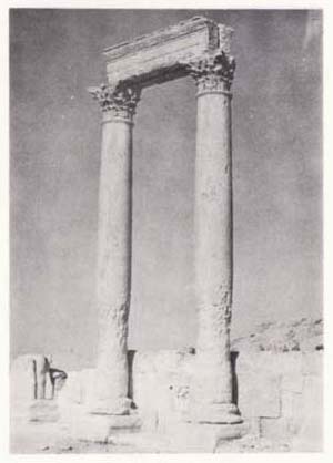
In the Palmyra Basin, the Sabha lies on the outskirts of wadi fans or wadi ends. Its elevation is nearly +380 m. This saline flat occupies an area about 10 × 15 km in the center of the basin. Analyses of sediments obtained by shallow boring show most of the deposits consisting of silt or mud, and suggest static depositional environments with no movement or flow of the lake water. But upper sediments tend to be aeolian sediments with rather well sorted sand grains. The basin was formed by tectonic depression during the Cenozoic and the lake might have existed for long periods in the Pleistocene. The depth of the Sabha sediments is unknown but most of the sediments suggest alternations of lacustrine and fluviatile deposits. During pluvial stages, the erosional base level might have been lower, as is suggested by the gradients of the wadi fan surfaces. This lower base level suggests the palaeolake might have been smaller or drained by an open wadi system. Gradually the wadi system became closed and the dry lake of the Recent developed. 6. NEBKAIn the marginal zones of Sabha, aeolian sand deposits form small scale sand dunes captured by halophytic plants. Such sand mounds are called nebka (Abdul-Salam, 1965) or dikaka (Glennie and Evamy, 1968) in Arabic. The Nebka fringes wadi fans and the Sabha, and is found also in wadi channels. These aeolian sand deposits have cross-lamination. On the surface of the dunes, there are small ripples caused by wind (Pl. V-3, a). The outline of each sand mound forms an ellipse with a long axis always running east-west. This suggests the Nebka develops under aeolian environments of the prevailing westerly during the dry summer season. The sand grains of quartz or other minerals are well rounded and the grain size distribution suggests that the main agent of transportation is wind. Dresh (1963) pointed out that the bases of columns in Roman ruins are influenced by extensive wind erosion (Pl. V-3, b).
Of the erosional and sedimentary environments in the Palmyra Basin, wind erosion and deposition in the summer dry season are important and should be considered in the analysis of the sedimentary conditions of the Douara Cave. BIBLIOGRAPHY
|