Submarine Caves in the Ryukyu Islands
|
A large number of submarine limestone caves have been found around relatively flat islets of the Ryukyu Islands. Most of them are winding, horizontal to stepwise tunnels, which are open to fore-reef slopes. Their entrances lie between sea level and about -40 m, and their lengths range from several meters to more than 70 m. The inner part of these caves is almost or totally dark and accessible only to skilled divers. All of these caves are in the Ryukyu Limestone (commonly 30-70 m thick), which was extensively deposited in this region during several interglacial stages of the Pleistocene (mainly after 500 Ka). They were probably formed by underground water during some lower sea-level stages and finally drowned during the post-glacial sea-level rise. Application of the accepted curves of the Holocene sea-level change in the Japanese Islands (Sugimura, 1977, etc.) indicates that all the marine organisms in these caves came from somewhere after 8,000 years B. P. Because the level of under ground water is considered to lie near or slightly above sea-level, these submarine limestone caves are probably inactive at present. In fact, the salinity of the sea water in these caves is usually normal, as observed by divers. Owing to the low energy of sea water, the bottom sediments on the cave floor are generally very fine except for organic remains, and almost free of coarse terrigenous material. We examined cryptic organisms in two caves of Ie Islet of Okinawa (Map 2), seven caves of Shimoji Islet and four caves of Irabu Islet, Miyako Islands (Map 3). Their popular names (among divers), entrance locations, bottom depths (for the entrances and the innermost parts) and some other features are enumerated below. Ie Islet in Okinawa Islands (Map 2)
1. "Shodokutsu (= small cave)", 26°42.9'N, 127°50.1'E, more than 30 m long, totally dark, winding and branching tunnel (- 20 to - 7 m deep). 2. "Daidokutsu (= large cave)", 26°42.9'N, 127°50.1'E, about 10 m long, very dark, cathedral-like wide cave (- 20 m deep). Shimoji Islet in Miyako Islands (Map 3)
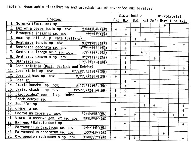
3. "Devil's Palace", 24°49.6'N, 125°08.2'E, about 15 m long, dark tunnel (- 25 m deep) with some narrow openings on the ceiling. 4. "Fool's Palace", 24°49.6/N, 125°08.2'E, about 10 m long, almost totally dark tunnel (- 35 to -32 m deep). 5. "Witch's House", 24°49.3'N, 125°08.3'E, more than 10 m long, totally dark tunnel (- 37 to - 35 m deep). 6. "Wall Cave", 24°49.1'N, 125°08.3'E, about 5 m long, dark tunnel (- 35 m deep). 7. "Toriike", 24°49.1'N, 125°08.3'E, a famous diving point, about 30 m long, large dark tunnel connected with two large passing ponds (- 40 to - 12 m deep). Sampling was also made from a side cave. 8. "Black Hole", 24°49.1'N, 125°08.3'E, about 70 m long, totally dark stepwise tunnel with an air pocket in the innermost part (-35 to 0 m deep). 9. "Coral Hole", 24°48.0'N, 125°09.0'E, about 5 m long, dark hole and tunnel (-35 m deep). Irabu Islet in Miyako Islands (Map 3)10. "Lunch Hole", 24°51.6'N, 125°10.0'E, totally dark hole with an entrance lying near the sea level (- 4 m deep). Unlike other caves the sediments contain considerable amount of terrestrial residual soil. 11. "W-arch", 24°51.7/N, 125°09.7'E, double dark caves with an opening on the ceiling (-15 to- 13 m deep). 12. "L-arch", 24°51.7'N, 125°09.7'E, very dark L-like hole and short cave (- 25 m deep). 13. "Cross Hole", 24°51.6/N, 125°09.5'E, dark complicated hole and 20 m long cave (- 25 to - 20 m deep). From the inner part of each cave several samples were obtained by SCUBA diving, and living specimens and empty shells were sorted for taxonomic studies (Table 1). The microhabitat of living bivalves can be roughly classified into 1) soft bottom surface, 2) hard bottom surface (blocks of wall rocks), 3) surface of annelid tubes on the sediments, and 4) surface of walls and ceilings (Table 2). Samples from the wall and ceiling were examined at several caves, especially "Shodokutsu", "Fool's Palace", "Witch's House", "Wall Cave", "Toriike", "Coral Hole", "W-arch" and "Cross Hole". Although sampling in other caves is still preliminary, we believe that most of the dominant bivalves in these caves are represented in our collection.
The sediment samples of the following caves outside the Ryukyu Islands were preliminarily examined for comparison. Only the occurrences of bivalves common with those in the Ryukyu Islands are listed in Table 2 and mentioned in the description of relevant species. 1. "Balicasag Cave", a diving point off Panglao Islet, southern coast of Bohol Island, the Philippines. 2. "Chandelier Cave", a popular diving point near Koror, Palau Islands (Republic of Belau). 3. Sheltered place around "Gyuchaku-iwa", at Kumoi near Matsuzaki, southwestern coast of Izu Peninsula, Shizuoka Pref., central Japan. |