INTRODUCTION
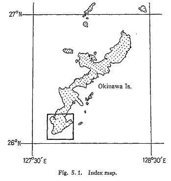
From 1969 to 1974 anthropological and paleontological surveys on diluvial sites of the Ryukyu Islands were carried out; several fragments of human bones and a number of vertebrate remains were excavated from a cave at Yamashita-cho and a fissure at Minatogawa, both in the southern part of Okinawa Island. Taking part in the surveys, the author had an opportunity to examine the geology and topography of Okinawa Island; the geology of the environs of Yamashita-cho cave has already been presented (Tsuchi, 1975). In this paper, geological sketches and some of the landforms of southern Okinawa Island are referred to, with special reference to the formation of the fissure at Minatogawa.
Here, the author expresses his sincere gratitude to Profs. Emer. T. Suzuki, F. Takai and N. Watanabe of the University of Tokyo, and to the late Prof. G. Tanabe of Ochanomizu University for their courtesy in allowing him to participate in the surveys. Many thanks are also due to Mr. M. Ôyama and all the staff of the mission for their cordial advice and help during the surveys.
GEOLOGY AND THE MINATOGAWA FISSURE
Geology and Topography of Southern Okinawa Island
In the southern part of Okinawa Island, massive silty beds of the Neogene Shimajiri Group are primarily found as the basement rocks of the area, being overlain by calcareous veneers called "Ryukyu Limestone" (Hanzawa, 1935; Yabe and Hanzawa, 1930) (Fig. 5. 2). The Shimajiri Group consists mainly of marine silt and clay with intercalations of thin sand layers, and exhibits monoclinal structures dipping to the southeast.
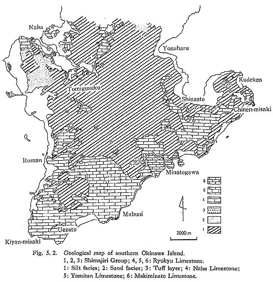
The "Ryukyu Limestone," forming a stepped terrace topography, extends along the coastal area, as if it fringes the southern part of the island, which has been divided into three disconformable units: Naha, Yomitan (Yontan) and Makiminato (Machinato) Limestones, in ascending order (Flint et al., 1959; MacNeil, 1960). Of these, the oldest or Naha Limestone, is the most extensive, and the depositional surface forms high-level terraces in the area. The Yomitan Limestone, which typically develops in the Yomitan area north of Naha City, is not found in the southern part of the island, though similar fades are found in an area of Yaejudake. The Makiminato Limestone distributes locally in Minatogawa and some other areas forming a middle-level terrace.
The Naha Limestone, 7-20 m thick, consists mostly of indurated medium-to coarsegrained lime sands, and partly of powdery to dense non-porous limestone. Some reefy corals are found near Minatogawa. The Yomitan Limestone has a texture similar to that of the Naha Limestone, but is characterized by algal bowls. The Makiminato Limestone, about 20 m thick, is a porous and poorly indurated foraminiferal sand containing a few colonial corals in the vicinity of Minatogawa. From the facies analysis, both the Naha and Makiminato Limestones represent, littoral sediments near coral reefs. In determining the geologic ages of the above-mentioned strata, the Shimajiri Group are assigned to ages covering from Late Miocene to the earliest Pleistocene, and the Ryukyu Limestone to Pleistocene (Ibaraki and Tsuchi, 1975; Natori, 1976).
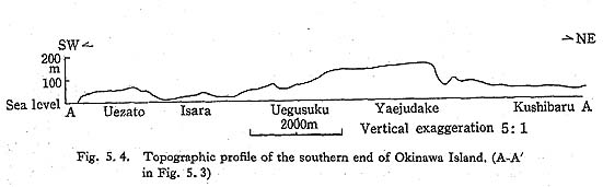
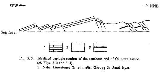
A cuesta-like topography by tilted fault-blocks of the Naha Limestone typically develops at the southern end of the island (Figs. 5. 3, 5. 4 and 5. 5). In general, the south side has tilted down relative to the north side in each block. As a result, steep scarps as high as 20 m face northward where silty rocks of the Shimajiri Group are sometimes found exposed under the Naha Limestone. It seems that the pattern of the faults is not a series of X intersections (Flint et al., 1959) but a series of rather scale-like patterns (Fig. 5. 3). Each fault line makes an arcuate curve, and each fault scarp forms an arcuate cliff. Minor antithetic faults parallel to the above-mentioned major faults can frequently be observed in the Shimajiri Group (Fig. 5. 5). Considering the experimental analysis of fracture patterns by Cloos (1968), this fault system of the scale-like pattern is due to neotectonics accompanied by a doming upheaval of the area afterthe deposition of the Naha Limestone.

Minatogawa Fissure and its Relation to Neotectonics of the Area
In the area of Minatogawa, the Makiminato Limestone develops in a depression of a graben of the Naha Limestone, the depositional surface of which makes a nearly flat terrace 20-40 meters in altitude (Fig. 5.6). The stratigraphic relation of the Makiminato Limestone to the Naha Limestone can be seen on the coast of Minatogawa, where the former is abutting and overlapping the latter. Two sets of wave-cut rerraces 15 m and 5 m above sea level are also recognized on the coast, the latter of which, fringing nearly the entire coast of southern Okinawa Island, is considered to be the raised beach of the Early Jomon age in the phase of the high sea level.

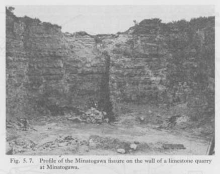
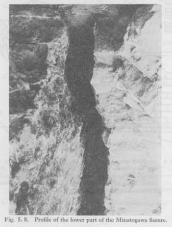
The Minatogawa fissure is a crack located near Minatogawa village, its slit opening onto the depositional surface of the Makiminato Limestone. It is 20 m above sea level, about 1 m wide at the maximum point and several meters long, being elongated in the direction of N60°-70°E. Vertical sections of the fissure are visible on a cliff by a limestone quarry and also in a cliff of the Yuhi River. The fissure has been filled by residual clay with travertine, limestone fragments and vertebrate remains.
A profile of the fissure shows it to stretch vertically nearly to sea level, where it narrows to only 40 cm in width. The uneven surfaces of the fissure walls fit quite well with each other. No shear zone or fault slip is recognized on the walls, and it is therefore most probable that the fissure is a kind of tension crack (Figs. 5. 7 and 5. 8).
On the terrace surface we can find similar cracks, running nearly parallel to the fissure and making a narrow fissure zone in a N60°-70°E direction, the extension of which coincides with a fault line of the Naha Limestone. As already stated, faults of the Naha Limestone are considered to relate to the neotectonics of the southern part of the island accompanied by a dome-like upwarping. The fissure zone of which the Minatogawa fissure is a part might, therefore, be tension cracks also caused by the neotectonics of the area, i.e., the continuation of the dome-like upwarping of the southern end of Okinawa Island after the deposition of the Makiminato Limestone.
From the topographic and stratigraphic viewpoints, the depositional surface of the Makiminato Limestone can be correlated with the terrace surface of the Makinoharan (or Shimosueyoshi) Stage on the Pacific coast of central and southwestern Japan (Tsuchi, 1970). The geologic age of the depositional surface of the Makiminato Limestone can, therefore, be estimated at 130,000 y.B.P. (Machida, 1973). Considering the process of the formation of the Minatogawa fissure, geologic ages of its deposits would follow formation of the depositional surface of the Makiminato Limestone, i.e., estimated later than 130,000 y.B.P.
CONCLUSION
In southern Okinawa Island, the Pleistocene Ryukyu Limestone, made up of the Naha Limestone and the Makiminato Limestone, is common along the coastal area, forming stepped terraces of calcareous veneers. High-level terraces in this area are composed of the Naha Limestone, and the middle-level one is of the Makiminato Limestone.
A series of scale-like fault patterns is recognized on the depositional surface of the Naha Limestone, especially at the southern end of the island; this is believed due to the neotectonics accompanied by a dome-like upwarping of the area after the deposition of the limestone.
The Minatogawa fissure is a kind of a tension crack opening on the terrace surface of the Makiminato Limestone in the Minatogawa area. This crack may have been caused by the continuation of the above upwarping at the southern end of the island.
Since the terrace surface of the Makiminato Limestone can be correlated with that of the Makinoharan (or Shimosueyoshi) Stage, the geologic ages of the Minatogawa fissure and its deposits are estimated to be later than 130,000 y.B.P.
REFERENCES
- Cloos, E. (1968)
- Experimental analysis of Gulf Coast fracture patterns. Amer. Assoc. Petrol.Geol. Bull., 52 (3), 420-444.
- Flint, D. E., et al. (1959)
- Military geology of Okinawa-jima, Ryukyu-Retto, 5. Geology.
- Hanzawa, S. (1935)
- Topography and geology of the Ryukyu Islands. Tohoku Imp. Univ. Sci. Rep., 2nd Ser. (Geology), 17(3,4), 107-110.
- Ibaraki, M, and Tsuchi, R. (1975)
- Planktonic foraminifera from the upper part of the Neogene Shimajiri Group and the Chinen Sand, the Okinawa Island. Rep. Fac. Sci., Shizuoka Univ., 10,115-130.
- Machida, H. (1973)
- Tephrochronology of coastal terraces and their tectonic deformation in south Kanto. Jour. Geog., 82 (2), 1-24.
- MacNeil, F. S. (1960)
- Tertiary and Quaternary Gastropoda of Okinawa. U.S. Geol. Surv. Prof. Paper, (339), 1-133.
- Natori, H. (1976)
- Planktonic foraminiferal biostratigraphy and datum planes in the late Cenozoic sedimentary sequence in Okinawa-jima, Japan. Progress in Micropaleontology, Takayanagi, Y. and Saito, T., eds., Micropaleontology Press, New York, 213-243.
- Tsuchi, R. (1970)
- Quaternary tectonic map of the Tokai region, the Pacific coast of central Japan. Rep. Fac. Sci., Shizuoka Univ., 5, 103-114.
- ——— (1975)
- Geology of southern Okinawa Island, with reference to the formation of the Yamashita-cho cave. Jour. Anthropol. Soc. Nippon, 83(2), 131-136.
- Yabe, H. and Hanzawa, S. (1930)
- Stratigraphy of Tertiary foraminiferal rocks of Taiwan (in Japanese). Geol. Papers for the Memory of Dr. T. Ogawa's 61th Birthday, 83-126, Ko-bundo, Tokyo.