In the center of the Palmyra Basin a lowland marsh called "Sabkha" is found.
It is about 25 km in length and 10 km in width, and is bare of vegetation.
During the rainy season, with an annual precipitation of from 80 to 120 mm,
a lake is formed in the Sabkha which usually evaporates during the dry season.
However, due to the unusually heavy rain and snow from 1973 to 1974, lake water
remained in August of 1974: the size of the lake was about 10 km in diameter.
Bushes and grass around the Sabkha help to form numerous small mounds of eolian
sand called "nebka" which develop occasionally into sand dunes. Around these
sand dunes a lacustrine terrace with a height of several meters exists, show
ing traces of a late Pleistocene. This terrace succeeds gradually to alluvial
fans around the foot of the mountains. The terrace's slopes are very steep,
and there is a relative height difference of about 40 m between the tops of
Sabkha and the alluvial fans.
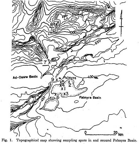
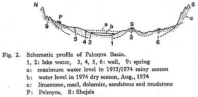
Many wells have been dug in these areas to secure drinking water and for agriculture. These wells are equipped with electric pumps. The water table for wells is about 20 m below the surface around the Palmyra Basin, but wells in the Sabkha are very shallow with depths of from 1 to 1.5 m. Springs in the adjoining areas of the basin and mountains are used for public bathing and laundry; these seem to be fissure water related to faults.
Around Isshet, on the surface of the maximum water level from the rainy season of an old lake shoreline, are scattered coarse grains of gypsum of various sizes from 1 to 5 cm in diameters among the sand or silt. In Isshet, gypsum chunks with 8 cm diameters are found. However their distribution is restricted to the shoreline of the maximum water level.
On observing these it was theorized that different kinds of inland water might exist in the surrounding region such as the Ad-Daww Basin, and Mt. Abou Rajmein. In order to clarify the chemical characteristics of the inland water, samples were taken at various spots.
The water balance of the Palmyra Basin is understood as follows. The mean annual pre cipitation is 100 mm and the calculated value of the annual evaporation from the lake surface is 1000 mm. As a result, 60% of the precipitation flows into the lake and 40% is evaporated from the Palmyra Basin.
This coefficiency of 60% is quite close to that of regions with similar geomorphological and climatical conditions.
As to the process of the concentration of the lake water, this can be divided as follows.
i) Short period; The lake water is concentrated when salt in the water falls out in the dry season and is diluted in the rainy season of each year.
ii) Long period; The lake water is concentrated by evaporation, which seems to have lasted for about 100,000 years.
iii) Concentration takes place in the stream in the basin while they are flowing.
These processes of concentration are shown in Figs. 2, 3 and 4. The well
water around Mt. Abou Rajmein and the snow in the mountainous region is of
the carbonate type as shown in Figs. 3 and 4 (samples 8 and 10). The chemical
characteristic changes to the sulfate type as shown in Fig. 4 (sample 7) due
to the precipitation of carbonate. The well water in the lacustrine terrace
is of the transit type, between sulfate and chloride types, as shown in Fig.
4 (samples 3 and 6). The lake water in Sabkha (samples 1, 2, 4 and 5) is of
the chloride type, representing the final stage of salt lakes due to concentration
by evaporation and the precipitation of sulfate.

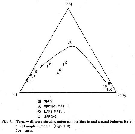
This observation is supported by various facts such as that carbonate precipitates as cementing materials in sediments are found along the wadi as well as in the matrix of sediments in alluvial fans, that a great deal of gypsum is found around the lakeshore level of the rainy season in the sediment of the lacustrine terrace, and that a thin white crust is left after the precipitation of salts in the center of the Sabkha. Salt fields are made by digging shallow ditches and holes; these supply salt of good quality for the inhabitants.
To summarize, a predominant anion in the water changes from carbonate to sulfate and finally to chloride as the water runs through the Palmyra Basin from a mountainous region to the lake. This is a stereotyped change from fresh lakes to saline lakes as seen in the lakes of the arid zones of the western part of the USA, and in Tibetian and Mexican plateaus as pointed out by Hutchinson (1975) and Frey (1963).
LITERATURE CITED
- Deer, et al. (1962)
- Rock Forming Minerals, 5: 205-215, 220-224.
- Eyre, S.R. (1971)
- World Vegetation Types. Geographical Reading Series, Macmillan.
- Fowie, F.E. (1933)
- Smithonian Physical Tables. 218-226, 230-231.
- Frey, D.G. (1963)
- Limnology in North America. The University of Wisconsin Press.
- Hutchinson, G.E. (1975)
- Chemistry of Lakes. A Treatise on Limnology, 1 (Part 2): 564-571.
- Philips, K.N.S. and van Denburgh, A.S. (1971)
- Hydrology and Geochemistry of Abert, Summer, and Goose Lakes, and other Closed-basin Lakes in South-Central Oregon. Geological Survey Professional Paper, 502-B.
- Suzuki, H. and Kobori, I. (eds.) (1970)
- Report of the Reconnaissance Survey on Palaeolithic Sites in Lebanon and Syria. Univ. Mus., Univ. Tokyo, Bull. 1.
- Thomas, M.F. and Whittington, G.W. (1969)
- Environment and Land Use in Africa. Methuen.
- U.S. Department of Commerce (1966)
- World Weather Records 1951-1960: Vol. 2. Europe.