Marhlouja (Site 25)
I. On N slope of Jebel Aabd el Aaziz. An area centering around the spring (Ain) of Marhlouja, about 30 km W of Hassetche (Fig. 24). II. Open site. A few complete flint implements. III. Post-Palaeolithic.
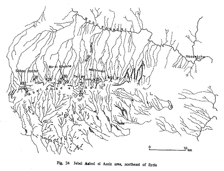
Cheikh Aabd el Aaziz (Site 26)
I. At Cheikh Aabd el Aaziz, about 16 km W of Marhlouja hamlet. On the slope of left bank of a. small wadi, which flows past both ends of the hamelt (Fig. 24). II. open site. Many complete flint implements. III. Post-Palaeolithic (Fig. 47:7,10,11,14,20).
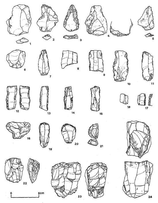
Figure 47 Flint Implements of the Post-Palaeolithic
1. Broad flake of Levallois technique. (El Rhara Open III, Site 31)
2. End-scraper on flake of Levallois technique. (El Rhara Open III, Site 31).
3. Triangular point on retouched flake of Mousterian technique. (El Rhara Open III, Site 31)
4. Roughly triangular flake, the striking-platform removed by chipping, (Khazne Cave I, Site 28)
5. Roughly triangular on flake of Levallois technique. (Sabaa Jaafar Open, Site 32)
6. Micro Levallois core. (Khazne Open III, Site 30)
7. Point on flake, and retouched into an end-scraper. (Cheikh Aabd el Aaziz, Site 26)
8. Sickle blade. (Soukkara Shelter, Site 27)
9. Sickle blade. (Khazne Open III, Site 30)
10. Backed sickle element on flake. (Cheikh Aabd el Aaziz, Site 26)
11. Sickele element on blade. (Cheikh Aabd el Aaziz, Site 26)
12. Sickle blade. (Khazne Cave I, Site 28)
13. Sickle blade. (Khazne Cave I, Site 28)
14. Sickle blade, and retouched into an end-scraper, (Cheikh Aabd el Aaziz, Site 26)
15. Blade used as sickle element, (Khazne Open III, Site 30)
16. Sickle blade. (Khazne Cave I, Site 28)
17. Sickle blade. (Khazne Cave I, Site 28)
18. T-shaped tool. (Khazne cave I, Site 28)
19. End-scraper. (Khazne Cave I, Site 28)
20. End-scraper. (Cheikh Aabd el Aaziz, Site 26)
21. Carinated end-scraper. (Soukkara Shelter, Site 27)
22. Core, and possibly used as axe. (Khazne Cave II, Site 29)
23. Core. (Khazne Cave II, Site 29)
24. Core. (Khazne Open III, Site 30) |
Soukkara Shelter (Site 27)
I. There is the Soukkara Roman site on the left bank upstream of Wadi Soussa, which flows about 5 km W of Marhlouja. This shelter is on the left bank of the small tributary which flows into the left side of the main stream about 3 km upstream from the Roman site. About 50 m upstream from the spot into which the tributary flows (Fig. 24). II. Small shelter. The greatest width about 20 m. About 20 m long. Hardly any deposit inside and outside of shelter. Most of the terrace reveals bedrock. Flints collected from all over the terrace. III. Post- Palaeolithic (Fig. 47: 8,21).
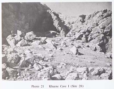
Khazne Cave I (Site 28)
I. On the N slope of Jebel el Aaziz. Cave about 2 km SW of Khazne, about 40 km W of Hassetche (Fig. 24). II. Cave faces approximately NE. The widest part of the opening is about 6 m. There is a big rock considered to be a part of the roof which has fallen, on N side. Presumed to have once had more than a 20 m opening. About 10 m long. Behind the cave is another cave about 4 m wide at the mouth and about 8 m long. The latter cave is presumed to have been connected with the cave in front, but became isolated because of the fall of the roof of the front cave. The floor of the cave behind is about 3 m higher than that of the front cave. Presumed that after it became isolated the deposits started to accumulate independently. The terrace is over 20 m in width, about 20 m in length, and it continues in front to the wadi which flows about 20 m away. A great quantity of big and small stones can be observed (Ph. 21). Flints scattered all over the terrace. III. Post-Palaeolithic (Fig, 47: 4,12,13,16-19).
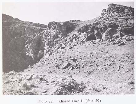
Khazne Cave II (Site 29)
I. About 2 km SE of Khazne. On the left bank, at the mouth of the first wadi on E side of Khazne (Fig. 24). II. About 21 m higher than the bottom of the wadi. Faces approximately NE. About 7 m both in width and length at the opening of the cave. Up to the Wadi which flows in front the terrace is about 30 m long. Big and small stone are scattered on the terrace (Ph. 22). III. Post- Palaeolithic (Fig. 47: 22,23).
Khazne Open III (Site 30)
I. An area on the bed of wadi Khazne, E of Khazne (Fig. 24). II. Open site. Centers around the wadi bed. Cannot be considered a living site. The remains could have been washed out of somewhere. III. Post-Palaeolithic (Fig. 47: 6,9,15,24).
El Rhara Open III (Site 31)
I. An area at the foot of Jebel Rhara, about 2 km W of el Rhara, and about 4 km W of Khazne (Fig. 24). II. Open site. III. Post-Palaeolithic (Fig. 47: 1,2,3).
Sabaa Jaafar Open (Site 32)
I. An area of the wadi which flows SE, about 2 km SE of Sabaa Jaafar, about 46 km E of Hassetche (Fig, 24). II. Open site. III. Post-Palaeolithic (Fig. 47: 5).
Mugharet el Douara V (Site 33)
I. About 20 km NE of Palmyra. On slope of Jebel ed Douara. Turns left near the point where Palmyra-Arak Desert Road crosses with Wadi Khaouabi el Harrar. About 200 m E of Mugharet el Douara I(Site 34) (Fig. 25). II. About 10 m wide at the opening of the cave, about 6.5 m long. Semi-oval, about 3 m height to the cave. The widest part of the terrace is about 30 m. About 5 m long. Bedrock exposed inside and outside the cave practically all over. Flints scattered all over the terrace. III. Post-Palaeolithic (Fig. 48: 4).


Figure 48 Flint Implements of the Post-Palaeolithic
1. Elongated triangular point on flake of Mousterian technique. (Wadi el Khalla Open, Site 76)
2. Triangular point on flake of Levallois technique. (Mugharet el Boireh, Site 52)
3. Scraper on thick flake retouched on the lower face. (Mugharet el Douara I, Site 34)
4. Triangular point on flake, broken. (Mugharet el Douara V, Site 33)
5. Side scraper on flake, retouched on the lower face. (Mugharet el Boireh, Site 52)
6. End scraper on thick flake. (Mugharet el Douara II, Site 36)
7. Transverse scraper on flake. (Dahr el Moussoum, Site 51)
8. End-scraper. (Mugharet el Douara IV, Site 38)
9. End-scraper. (Mizra II, Site 68)
10. End-scraper. (Wadi el Khalla (2) II, Site 75)
11. End-scraper. (Jerf Dahr al Auwad I, Site 63)
12. End-scraper, (Wadi el Ahmar L-5, Site 48)
13. Double end-scraper. (Mugharet el Douara VI, Site 37)
14. Borer, (Mugharet el Douara II, Site 36)
15. Borer on flake. (Jerf Qatar II, Site 65)
16. Borer, on blade. (Jerf Qatar I, Site 64)
17. Borer on long blade, (Dahr Rouaissafe Open II, Site 60)
18. Borer on flake. (Jerf Qatar II, Site 65) |
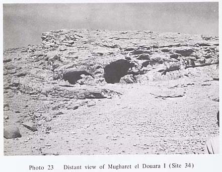
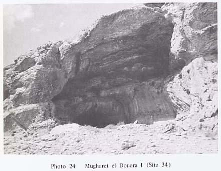
Mugharet el Douara I(Site 34)
I. About 18 km NE of Palmyra. Turning left at the spot where Palmyra-Arak Desert Road crosses with Wadi Khaouabi el Harrar, one soon sees the large cave on the S slope of Jebel ed Douara. The biggest cave in Jebel ed Douara (Fig. 25). II. Cavefaces approximately S. About 14.5 m wide at the opening, and about 12 m long. Height of eave is more than 10 m. The width of the terrace is 4-5 m, about 30 m long, corridor-shaped, surrounded by bedrock on both sides. Doubtful whether this part contains deposit or not (Phs. 23, 24). The only places where deposits are clearly observed are the inside of the cave, the corridor-like part of the terrace, and the area beyond 30 m in front of the cave. Flints scattered all over the terrace. III. Middle Palaeolithic and post-Palaeolithic (Figs. 41:1-7, 48:3, 49:13, 50:1,7, 52:3), and possibly Upper Palaeolithic.

Figure 41 Flint Implements of the Middle Palaeolithic
1. Elongated retouched Levallois flake with retouched striking-platform. (Mugharet el Douara I, Site 34)
2. Scraper on broad Levallois flake with retouched striking-platform. (Mugharet el Douara I, Site 34)
3. Triangular point on Levallois flake with retouched striking-platform. (Mugharet el Douara I, Site 34)
4. Double side scraper on square-ended thick Levallois flake with small retouched striking platform. (Mugharet el Douara I, Site 34)
5. Triangular point on retouched Levallois flake. (Mugharet el Douara I, Site 34)
6. Roughly triangular point on Levallois flake with retouched striking-platform. (Mugharet el Douara I, Site 34)
7. End-scraper on Levallois flake with small faceted striking-platform. (Mugharet el Douara I, Site 34) |
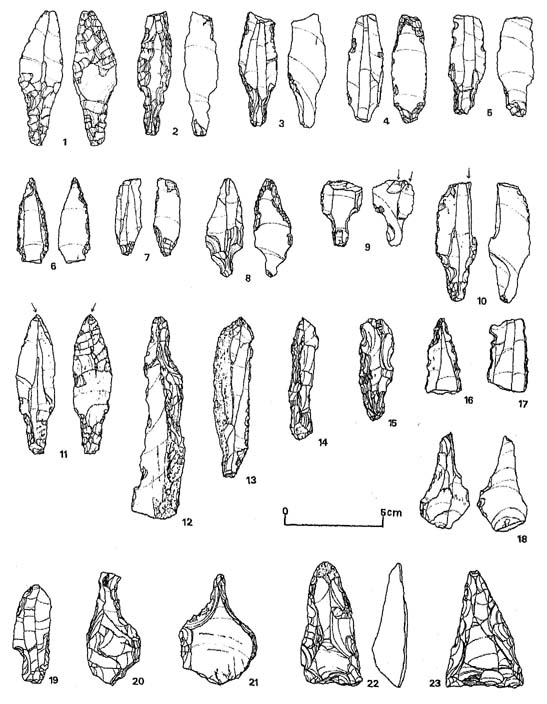
Figure 49 Flint Implements of the Post-Palaeolithic
1. Arrowhead with broad tang, pressure-flaked on the lower face of the point and on both faces of the tang. (Mugharet el Boireh, Site 52)
2. Arrowhead with long tang, pressure-flaked on the upper face and on the lower face of the tang. (Mugharet el Douara III, Site 35)
3. Arrohead; pressure-flaking on the upper face of the tang. (Mizra III, Site 69)
4. Arrowhead; pressure-flaking on the lower face, broken. (Mugharet el Boireh, Site 52)
5. Tanged arrowhead; pressure-flaking on both faces of the tang, broken. (Wadi el Khalla (2) I, Site 74)
6. Broken arrowhead, possibly reused as borer; tang missing. (Mizra I, Site 66)
7. Arrowhead; pressure-flaking on both faces of the tang, broken. (Tell Aaleitite II, Site 53)
8. Arrowhead on flake, retouched only on the lower faces. (Wadi el Khalla (2) I, Site 74)
9. Tanged arrowhead, and possibly reused as graver. (Wadi el Khalla (2) I, Site 74)
10. Arrowhead with long tang, pressure-flaked only on the upper' face of the tang and reused as graver. (Mugharet el Chaaite, Site 77)
11. Tanged arrowhead, pressure-flaked on both faces of the tang and on the lower face of the point. (Mugharet el Chaaite, Site 77)
12. Pick on trihedral long blade, (Mugharet el Douara II, Site 36)
13. Point on elongated blade, retouched on the right edge. (Mugharet el Douara I, Site 34)
14. Scraper on trihedral blade. (Mugharet el Douara II, Site 36)
15. Notched element. (Jerf Dahr al Auwad II, Site 71)
16. Notched element, possibly used as borer. (Jerf Dahr al Auwad II, Site 71)
17. Notched element on blade. (Wadi el Ahamar R-3, Site 43)
18. Awl on flake. (Tell Aaleitite II, Site 53)
19. Notched element. (Mizra II, Site 68)
20. Awl. (Dahr el Moussoum, Site 51)
21. Awl. (Jerf Abou Tafat, Site 62)
22. Core axe. (Mugharet el Boireh, Site 52)
23. Core axe. (Wadi el Ahmar R-2, Site 42) |

Figure 50 Flint Implements of the Post-Palaeolithic
1. Graver on end-scraper. (Mugharet el Douara I, Site 34)
2. Graver on end-scraper. (Mugharet el Chaaite, Site 77)
3. Graver. (Mugharet el Douara VIII, Site 40)
4. Graver on notched blade. (Mugharet el Douara II, Site 36)
5. Graver on blade, retouched on the lower face. (Mugharet el Douara III, Site 35)
6. Graver. (Wadi el Ahmar L-l, Site 44)
7. Graver. (Mugharet el Douara I, Site 34)
8. Graver. (Mizra IV, Site 70)
9. Graver. (Dahr Rouaissafe Open II, Site 60)
10. Graver on retouched blade. (Mugharetel Douara II, Site 36)
11. Angle graver on retouched blade, (Mugharet el Chaaite, Site 77)
12. Graver. (Mugharet el Douara II, Site 36)
13. Graver on broken pick. (Mugharet el Douara II, Site 36)
14. Graver. (Tell Aaleitite, Site 53)
15. Angle graver. (Wadi el Khalla (2) I, Site 74) |

Figure 52 Flint Implement of the Post-Palaeolithic
1.Bifacial axe, broken. (Jerf Abou Tafat, Site 62)
2.Prismatic core. (Mugharet el Douara II, Site 36)
3.Conical core. (Mugharet el Douara I, Site 34)
4.Prismatic core. (Mugharet el Douara II, Site 36) |
Mugharet el Douara III (Site 35)
I. About 100 m W of Mugharet el Douara I (Site 34) (Fig. 25). II. About 7 m wide at the mouth of cave, about 4 m long. The eave is 1.6 m high. Has 7-8 m long terrace. Practically all of inside and outside of the cave is exposed bedrock. Flints scattered all over the terrace. III. Post-Palaeolithic (Figs. 49:2, 50:5).
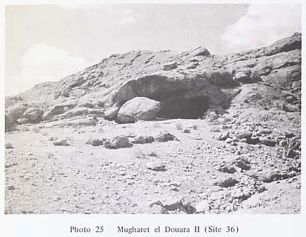
Mugharet el Douara II (Site 36)
I. About 200 m W of Mugharet el Douara I (Site 34). Further W of Douara III (Site 35) (Fig. 25). II. The cave faces approximately SE. A small cave about 10 m wide at the mouth, about 6 m long; the height of the cave is about 3 m. A narrow and long corridor extends from SW comer of the cave. The widest part of the terrace is about 15 m, having a length about 40 m. Its E and SE parts are cut by a small wadi. Bedrock is exposed in the northern half of the inside of the cave. Rock is exposed at some parts of the terrace, but doubtful whether it is bedrock or not. There is a big rock in front of the cave mouth. Is a part of the cave which has crumbled and fallen (Ph. 25). Many flints all over the terrace. III. Post-Palaeolithic (Pigs. 48:6,14, 49:12,14, 50:4,10,12,13, 51:4-7, 52:2.4). Possibly Middle Palaeolithic.
Mugharet el Douara VI (Site 37)
I. About 1 km W of Mugharet el Douara II (Site 36) (Fig. 25). II. The cave faces SW. About 5.5 m wide in the mouth and 5.5 m long. The widest part of the terrace is about 30 m, about 60 m long. Slopes sharply toward the bottom of the wadi. Bedrock exposed inside and outside the cave. Many flints scattered on the terrace. III. Post-Palaeolithic (Fig. 48:13).
Mugharet el Douara IV (Site 38)
I. On S slope of Jebel Douara. On the right bank, upstream of a small wadi which runs approximately in the middle between Wadi el Khaouabi el Harrar and Wadi el Ahmar, from S to N (Fig. 25). II. The cave faces approximately NE, About 12 m wide in the mouth, and about 7 m long, Height of the cave is about 3.6m. The widest part of the terrace is about 15m. About 6 m long. Further down sloping sharply the bottom of the wadi. Bedrock is completely exposed inside the cave. Many flints scattered from the terrace to all over the wadi bed. III. Post-Palaeolithic (Fig. 48:8).
Mugharet el Douara VII (Site 39)
I. On the left bank, a few dozen m upstream of Wadi el Mohaseh, a small tributary of Wadi el Ahmar which flows from S to N on the west end of Jebel ed Douara (Fig. 25). II. Elongated cave, about 8 m wide at the opening, about 3 m long, and the height of eave 1.6 m. A stone wall has been constructed at the mouth up to the ceiling. The widest part of the terrace is about 50 m. Hardly any deposit can be expected inside and outside of the cave. A small quantity of flints scattered on the terrace. III. Post-Palaeolithic.
Mugharet el Douara VIII (Site 40)
I. About 100 m E of Mugharet el Douara VII(Fig. 25). II. About 8 m wide. at the opening, and 8 m long. Stone wall has been constructed to shut the opening of the cave. The widest part of the terrace is about 30 m, about 50 m long, slopes gently down. Hardly any deposit inside and outside the cave. Flints scattered all over the terrace. III. Post-Palaeolithic (Fig. 50:3).
Wadi el Ahmar R-1 (Site 41)
I. On the left bank of the small tributary which flows into the right bank about 1 km upstream from the valley mouth of the Wadi el Ahmar, which flows from the west end of Jebel ed Douara (Fig. 25). II. Shelter 30 m higher than the wadi bed. The cave has almost crumbled. The terrace slopes sharply toward the bottom of wadi. Hardly any deposit within the shelter. III. Post-Palaeolithic.
Wadi el Ahmar R-2 (Site 42)
I. About 10 m upstream, on the opposite bank of Wadi el Ahmar R-1 (Site 41) (Fig. 25). II. About 20 m from the wadi bed. About 10 m wide at the opening of the cave, about 5 m long. The terrace slopes sharply toward the wadi bottom. Hardly any deposite inside and outside the cave. Many flints scattered from the terrace to the wadi. III. Post-Palaeolithic (Figs. 49:23, 51:10).
Wadi el Ahmar R-3 (Site 43)
I. On the right bank of a small tributary which flows into the right bank of Wadi el Ahmar, at a spot about 30 minutes on foot from the valley mouth (Fig. 25). II. The cave faces approximately N. The width at the opening and length are both about 9 m. The height of the eave is 4-5 m. A stone wall has been constructed at the opening. The length of the terrace is about 60 m, reaching the wadi with about a 15° inclination. Bedrock is exposed at both ends of the terrace and is buried elsewhere under the terrace in a 15° - 20° inclination. Flints are scattered all over the terrace. III. Post-Palaeolithic (Fig. 49:17).
Wadi el Ahmar L-1 (Site 44)
I. About 500 m upstream of a tributary which branches out from Wadi el Ahmar. The tributary flows into the mainstream from its left bank, a few hundred m upstream from the valley mouth (Fig. 25). II. The cave is semi-oval, about 9 m wide at the opening, about 4 m long, and the height of the eave is about 4 m. It reaches the bottom of the wadi in about a 20° incline. Hardly any deposit inside the cave. Flints scattered all over the terrace. III. Post-Palaeolithic (Figs. 50:6, 51:9,11).

Figure 51 Flint Implements of the Post-Palaeolithic
1. Possibly graver on retouched blade. (Dahr Rouaissafe Open II, Site 60)
2. Possibly graver. (Mizra I, Site 66)
3. Possibly graver. (Jerf Qatar I, Site 64)
4. Possibly graver on elongated notched blade. (Mugharet el Douara I, Site 36)
5. Possibly graver on retouched blade. (Mugharet el Douara II, Site 36)
6. Possibly on notched blade. (Mugharet el Douara II, Site 36)
7. Possibly graver on trihedral blade. (Mugharet el Douara II, Site 36)
8. Nosed scraper. (Mizra III, Site 69)
9. Core or steep scraper. (Wadi el Ahmar L-l, Site 44)
10. Steep scraper. (Wadi el Ahmar R-2, Site 42)
11. Steep scraper. (Wadi el Ahmar L-l, Site 44)
12. Steep scraper, showing a marked twisting of the scraper front. (Mizra IV, Site 70)
13. Steep scraper, showing a marked twisting of the scraper front. (Jerf Dahr al Auwad I, Site 63)
14. Core, and possibly reused as scraper. (Mizra III, Site 69)
15. Bifacial axe, broken. (Jerf Abou Tafat, Site 62)
16. Broken bifacial axe and possibly reused as core. (Jerf Qatar I, Site 64) |
Wadi el Ahmar L-2 Open (Site 45)
I. On the right bank of the upstream area of Wadi el Ahmar L-1 (Site 44) (Fig. 25). II. Open site. Small quantity of flints scattered on the terrace. III. Post-Palaeolithic.
Wadi el Ahmar L-3 (Site 46)
I. The tributary which flows into the left bank of the Wadi el Ahmar, about 2 km upstream is divided into two tributaries further upstream. The cave is on the small tributary which flows into the southern one (Fig. 25). II. Elongated cave, about 7.5 m higher than the wadi bed. About 18 m wide at the cave mouth, about 3.5 m long, and height of eave is about 4 m. The widest part of the terrace is about 30 m, about 30 m long, slopes gently down the wadi bed. Deposit presumed to be thin. Very few flints. III. Post-Palaeolithic.
Wadi el Ahmar L-4 (Site 47)
I. About 100 m upstream, opposite bank of wadi el Ahmar L-3 (Site 46) (Fig. 25). II. The cave is about 5 m from the wadi bed. Open to S about 5.5 m wide at the mouth, about 4 m long. Height of eave is about 3 m. Rectangular in shape. The widest part of the terrace is about 30 m, 10-15 m long. Hardly any deposit inside and outside the cave. Very few flints. III. Post-Palaeolithic.
Wadi el Ahmar L-5 (Site 48)
I. On the right bank of the mid-stream of a small tributary flowing on N side of Wadi el Ahmar L-3 (Site 46) and L-4 (Site 47) (Fig. 25). II. Open site. Many flints scattered all over the terrace. III. Post-Palaeolithic (Fig. 48:12).
Wadi el Ahmar R-4 Open (Site 49)
I. On the N slope approximately in the center of Dahr el Mhasse, on the opposite bank to Jebel ed Douara, away from Wadi el Ahmar. (Fig. 25). II. Open site. III. Post-Palaeolithic.
Wadi el Ahmar Open (Site 50)
I. On the right bank of a small tributary which flows into the left bank of Wadi el Ahmar, about 3 km upstream from valley mouth (Fig. 25). II. Open site. Densely clustered flints were discovered within a 1 × 1 m space, about 3 m up from the wadi bed. III. Post-Palaeolithic.
Dahr el Moussoum (Site 51)
I. About 20 km NE of Palmyra. About 600 m high, on N slope of Dahr el Moussoum, NW of Jebel ed Douara (Fig. 25). II. About 2.5 m higher than the wadi bed. Consists of 2 caves, big and small. Both face N, The entrances are closed with stone walls. The big cave has an opening 9 m wide, 4.5 m long. The height of eave is 2.5 m. The smaller cave is 4 × 3 × 2 m. The terrace is wide and big, reaching the bottom of the wadi. Most of the deposits inside the caves have been washed away. Flints are scattered all over the terrace. III. Post-Palaeolithic (Figs. 48:7, 49:20).
Mugharet el Boireh (Site 52)
I. On the SE slope of Dahr el Youssefiye, NW side of Dahr el Moussoum (Fig. 25). II. Low cave, about 7 m wide at the opening, about 4 m long and height of eave is 2 m. The opening is closed with a stone wall. The depth of the terrace is nearly 70 m, but the bedrock is exposed all over the terrace. Deposits in the cave have been completely eliminated and are piled up into a mound in front of the cave. Flints are scattered all over the terrace. Flints are also found in the deposit artificially piled up in front of the cave. III. Post-Palaeolithic (Figs, 48:2,5, 49:1,4,22).
Tell Aaleitite II (Site 53)
I. On the N slope of Tell Aaleitite, about 17 km NNE of Palmyra (Fig. 26). II. The cave is about 8 m wide at the opening, about 6 m long, and height of the eave is about 2.5 m. The terrace slopes gently down to the wadi, more than 100 m ahead. The inside of the cave is being partly utilized as a store room for feed. Condition of deposit is not clear. Flints cover all the terrace. III. Post-Palaeolithic (Figs. 49:7,18, 50:14).
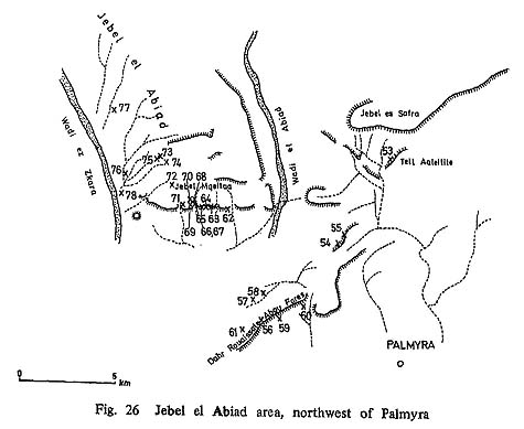
Jebel Blata I (Site 54)
I. About 8 km N of Palmyra. On W slope of Jebel Blata. About 5 km E after the fork of the road to the right at a spot going down to the valley of Abiad, the road leading to Wadi el Abiad from Palmyra (Fig. 26). II. The cave is about 7 m wide at the opening, about 5 m long. The height of eave is about 2 m. The terrace starts from about 4.5 m below the cave floor and with rather sharp inclination continues on to the wadi bottom. No deposits found inside the cave. Flints all over the terrace. III. Post-Palaeolithic.
Jebel Blata II (Site 55)
I. About 200 m E of Jebel Blata (Fig. 26). II. Rectangularly shaped cave, about 8.5 m wide, and about 8.5 m long. The height of eave is about 2 m. The opening is closed with a stone wall. The terrace is ranter wide and flat. It is divided into several blocks with stone walls. Considerable work has been on the terrace. Flints are scattered all over the terrace. III. Post-Palaeolithic.
Dahr Rouaissafe Cave (Site 56)
I. About 9 km NW of Palmyra. On the W slope of the highest peak of Dahr Rouaissafe Abou Fares. About 200 m W of the peak (Fig. 26). II. Small cave, about 7 m at the opening, about 4 m long. The terrace, length about 19m, slopes sharply and continues on to the wadi. Deposits found inside and outside the cave. A little disturbance noticed inside the cave. Flints scattered inside and outside the cave. III. Post-Palaeolithic.
Dahr Rouaissafe Shelter I (Site 57)
I. On the right bank of a shallow wadi, which flows on N side of Dahr Rouaissafe Abou Fares (Fig. 26). II. Slender shelter about 10 m wide, and about 3 m long. Wide terrace extends to the wadi in front. No deposit within the shelter. Flints all over the terrace. III. Post-Palaeolithic.
Dahr Rouaissafe Shelter II (Site 58)
I. A little over 10 m N of Dahr Rouaissafe Shelter I (Site 57) (Fig. 26). II. A shelter more than 10 m wide at its widest point. Thin deposits both inside and outside the shelter. Flints scattered all over the terrace slope. III. Post-Palaeolithic (Fig. 50:9).
Dahr Rouaissafe Open I (Site 59)
I. On slope of the highest peak of Dahr Rouaissafe Abou Fares (Fig. 26). II. Open site. III. Post-Palaeolithic.
Dahr Rouaissafe Open II (Site 60)
I. On slope of Dahr Rouaissafe Abou Pares (Pig. 26). II. Open site. III. Post-Palaeolithic. (Figs. 48:17, 51:1).
Dahr Rouaissafe Open III (Site 61)
I. On NW slope of Dahr Rouaissafe Abou Fares (Fig. 26). II. Open site. III. Post-Palaeolithic.
Jerf Abou Tafat (Site 62)
I. On S slope of Jebel Mqeita southernmost block of Jebel el Abiad, NNW of Palmyra. Along with this cave, there is Jerf Ajla site, investigated by Dr. COON (1957), about 1 km E of this cave (Fig. 26). II. This is name is to be given for the group of shelters and caves lined up westwards from the valley mouth of Wadi el Mqeita, which flows from Jebel Mqeita. The internal width of the site is about 40 m, and half of it is a shelter. At its edge there is a small cave, about 12 m wide at the mouth, and 2-3 m long. The eaves of shelters are all shallow, 1-2 m. The former is accompanied by a wide terrace. Many flints are scattered all over the terrace. III. Post-Palaeolithic (Figs. 49:21, 51:15, 52:1).
Jerf Dahr al Auwad I (Site 63)
I. About 1 km W of Jerf Abou Tafat (Site 62) (Fig. 26). II. The cave opens to approximately N. About 18 km wide at the opening, 2-3 m long. Shelter-shaped. Bedrock is exposed at various places on the terrace. III. Post-Palaeolithic (Figs. 48:11, 51:13).
Jerf Qatar I (Site 64)
I. About 200 m W of Jerf Dahr al Auwad I (Site 63) (Fig. 26). II. Narrow cave, facing SW. About 10 m wide at the mouth, about 1.5 m long. The height of eave is about 1.4 m. The part of the terrace which is surrounded by two small wadi that flow from NW to SE, is about 20 m in size, both in length and width. Many flints occur on the terrace. III. Post-Palaeolithic (Figs. 48:16, 51:3,16).
Jerf Qatar II (Site 65)
I. In the same valley as Jerf Qatar I (Site 64), in its W, across the small wadi (Fig. 26). II. About 8 m from the wadi bed. Extremely crumbled cave. The mouth is closed by a stone wall. Practically no deposit inside and outside cave. Many flints are scattered all over the terrace. III. Post-Palaeolithic (Fig. 48:15,18).
Mizra I (Site 66)
I. About 13 km NNW of Palmyra. On the left bank of Wadi Mizra which flows from Jebel Mqeita. W of the group of Jerf Qatar sites (Fig. 26). II. The cave is at a point 5 m apart from the wadi bed. About 13 m wide at the mouth, 3.5 m long. The eave is about 1.4 m high. Small terrace. Deposits inside the cave have been removed, and the cave is being utilized as a store room for sheep feed at present. No deposits on the terrace either. III. Post-Palaeolithic (Figs. 49:6, 51:2).
Mizra I' (Site 67)
I. Below Mizra I (Site 66) (Fig. 26). II. 4.5 m wide at the cave mouth, about 1.5 m long. Height of eave is about 1.3 m. Small. Accompanied by a terrace about 10 m length. Deposit observed inside and outside the cave. Flints are scattered all over the terrace. III. Post-Palaeolithic.
Mizra II (Site 68)
I. On the left bank of Wadi Mizra. A few hundred m upstream from Mizra I (Site 66) (Fig. 26). II. About 10 m higher from the wadi bottom. About 10 m wide at the cave mouth, about 2 m long. Height of the cave is about 1.4 m. The cave opens on a terrace about 30 m long, that slopes gently down to the wadi. Deposits inside and outside of the cave. III. Post-Palaeolithic (Figs. 48:9, 49:19).
Mizra III (Site 69)
I. On the right bank of Wadi Mizra. Some distance downstream from the opposite bank of Mizra I (Site 66) (Fig. 26). II. About 6 m higher than the wadi bottom. The cave is about 14 m wide at the mouth. Exposed bedrock forms most of inside and outside walls of the cave. III. Post-Palaeolithic (Figs. 49:3, 51:8,14).
Mizra IV (Site 70)
I. Upstream from Mizra III (Site 69). On the right bank of Wadi Mizra (Fig. 26). II. Big cave facing SE. About 19 m wide at the mouth, and about 9 m long. A small wadi flows about 40 m away from the cave, which is 7 m above the wadi bottom. Many stones fallen on the terrace, but the terrace is mostly flat and slopes gently down to the wadi. Exposed bedrock on inner W side of the cave. This bed continues to the N side of the terrace where it is exposed. III. Post-Palaeolithic (Figs. 50:8, 51:12).
Jerf Dahr el Auwad II (Site 71)
I. About 14 km NW of Palmyra. 200 m upstream W of Wadi Mizra (Fig. 26). II. The cave faces approximately W. About 13 m wide at the mouth, about 6 m long. Height of eave is about 5 m. At present it is used to store feed. A terrace of about 20 m slopes gently down to the wadi bottom. Bedrock is exposed on NE inner side of the cave. Huge rocks at some places of the terrace, possibly bedrock. III. Post-Palaeolithic (Fig. 49:15,16).
Mugharet el Maalauwi (Site 72)
I. On the right bank near the source of the Wadi Khalla, which enters the left bank of Wadi ez Zkara which runs N-S at the W end of Jebel el Abiad (Fig. 26). II. A big and a small cave face approximately SE. The big one is about 30 m wide, and about 7 m long. The small one is about 10 m wide, and about 5 m long. The height of the eave of both caves is about 4 m. The widest part of the terrace is about 40 m, and about 50 m long. The deposit inside the caves has been completely washed away. Bedrock is completely exposed in the part of the terrace nearer the caves. Not much deposit can be expected in the other parts of the terrace. III. Post-Palaeolithic.
Wadi el Khalla (2) Cave (Site 73)
I. On the right bank of the valley head of Wadi el Khalla (2), a tributary of Wadi ez Zkara (Fig. 26). II. About 50 m from the wadi bed. Faces SW. About 15 m wide at the mouth, and about 6.5 m long. Height of eave is about 1.7 m. Terrace width is about 18 m length. III. Post-Palaeolithic.
Wadi el Khalla (2) I (Site 74)
I. Near the source of Wadi el Khalla (2), immediately below the mountain ridge (Pig. 26). II. Paces SE. A small cave, about 4 m wide at the mouth and 4 m long. A wide terrace. III. Post-Palaeolithic (Figs. 49:5,8,9, 50:15).
Wadi el Khalla (2) II (Site 75)
I. About 50 m W of Wadi el Khalla (2) cave (Site 73) (Fig. 26). II. Presumed to have been a cave, but the eave has collapsed completely. A terrace no more than 10 m in length. III. Post-Palaeolithic (Fig. 48:10).
Wadi el Khalla Open (Site 76)
I. An area on the bed of Wadi el Khalla which flows into the left bank of Wadi ez Zkara, and also the area l-5 m or less the above the wadi bed, which may be flooded when the water rises (Fig. 26). II. This is not a site. The flints must have been washed out from somewhere. III. Post-Palaeolithic (Fig. 48:1).
Mugharet el Chaaite (Site 77)
I. On the left bank of Wadi el Chaaite which flows into the left bank of Wadi ez Zkara's upstream (Fig. 26). II. About 7 m higher than the wadi bed. Faces SW. The cave is about 10 m wide at the mouth, and about 7 m long. Height of the eave is about 7 m. The width of the terrace is narrow and its length is about 7 m. Hardly any deposit. Bedrock is exposed in more than half the cave. III. Post-Palaeolithic (Figs. 49:10,11, 50:2,11).
Wadi ez Zkara Open (Site 78)
I. On the right bank of the Wadi ez Zkara mouth. At W foot of Jebel Mqeita (Fig. 26). II. Open site. On the bank which is 5-10 m higher than the wadi bed. III. Post-Palaeolithic.
Tell el Madar (Site 79)
I. A few km N of el Kaum, about 70 km NE of Palmyra (Fig. 27). II. Around the modern well dug in the center of the tell. The depth of the well is presumed to be more than 10 m. Many flints are mixed in the dug out soil. III. Middle Palaeolithic (Fig. 42:2,5).
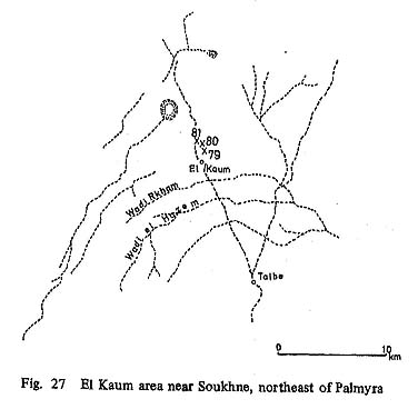
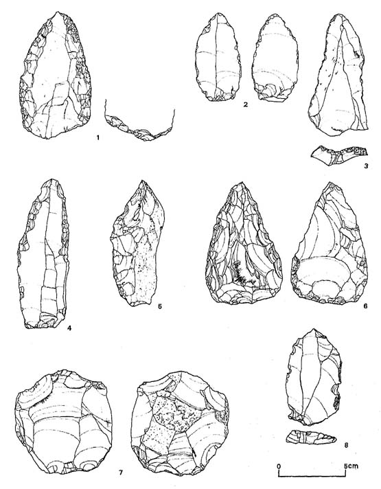
Figure 42 Flint Implements of the Middle Palaeolithic
1. Scraper (racloire convergent), the striking-platform removed by chipping from the upper face. (Tell Oumn Teil, Site 81)
2. Point on Levallois flake-blade with plain striking-platform. (Tell el Madar, Site 79)
3. Triangular point on Levallois flake-blade with retouched striking-platform, nibbled on the left edge. (Tell Oumn Teil, Site 81)
4. Elongated point on Levallois flake-blade with plain striking-platform. (Tell Hassan Unozi, Site 80)
5. Trihedral scraper, cortex left on the right side of the upper face. (Tell el Madar, Site 79)
6. Roughly pear-shaped biface. (Tell Hassan Unozi, Site 80)
7. Discoidal core. (Tell Hassan Unozi, Site 80)
8. Levallois flake with retouched striking-platform. (Dahr Souesso Open, Site 98) |
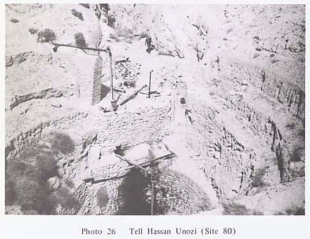
Tell Hassan Unozi (Site 80)
I. Near el Kaum (Fig. 27). II. Similar to Tell el Madar (Site 79) (Ph. 26). III. Middle Palaeolithic (Fig. 42:4,6,7).
Tell Oumn Teil (Site 81)
I. Near el Kaum (Fig. 27). II. Similar to Tell el Madar (Site 79). III. Middle Palaeolithic (Fig. 42:1,3).
Yabroud Shelter VIII(Site 82)
I. On a valley about 2 km N of Skifta Valley, which contains the famous Yabroud sites (RUST, 1950). About 1 km upstream from the mouth of the valley. In the center of a spot which divides the valley into E and W (Fig. 28). II. The shelter is about 20 m higher than the wadi bed. It is about 15 m wide at the mouth, about 5 m long. Elongated shelter. The eave is low. The terrace leads to the wadi bed in a sharp incline. III. Not identified.
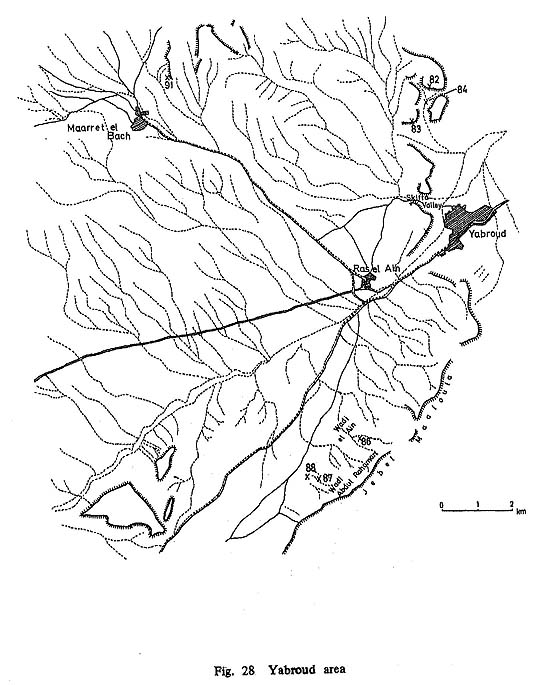
Yabroud Cave III (Site 83)
I. On N side of Skifta Valley. On the left bank of a big valley which runs approximately W into Skifta Valley. The first cave from the valley mouth on the left bank (Fig. 28). II. A big cave. Bed exposed. Many huge rocks on the terrace. III.Not indentified.
Yabroud Open III (Site 84)
I. An area on the wadi bed of the valley where Yabroud Shelter VIII (Site 82) exists (Fig. 28). II. Not appropriate to name it a living site since it is a wadi bed. III. Not identified.
Jebel Maaloula Cave (Site 85)
I. On SE slope of Jebel Maaloula. Approximately in the middle of Jabaadine which is in the same mountain, and Maaloula (Fig. 29). II. The cave has a crevice in the ceiling. The terrace sharply slopes toward the wadi. III. Post- Palaeolithic (Fig. 53:13-14).

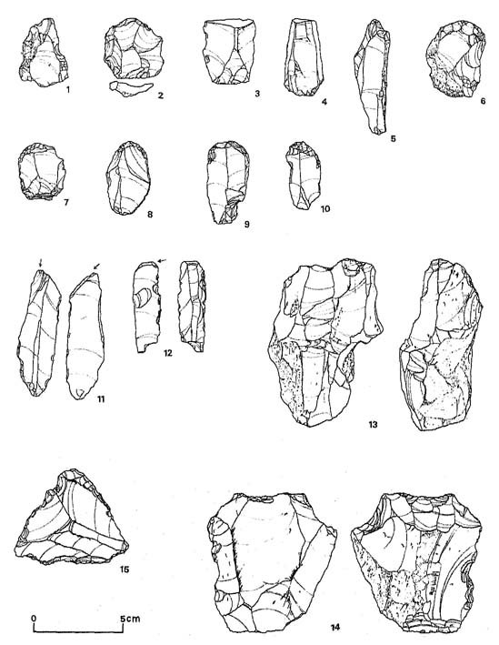
Figure 53 Flint Implements of the Post-Palaeolithic
1. Scraper on triangular flake of Levallois technique. (Wadi Abdul Rahman Open, Site 88)
2. Flake scraper of Levallois technique. (Wadi Abdul Rahman Open, Site 88)
3. Utilized blade. (Ain es Saheb II, Site 90)
4. Utilized blade. (Ain es Saheb II, Site 90)
5. Naturally backed blade. (Wadi Abdul Rahman R-l, Site 87)
6. End scraper. (Wadi Abdul Rahman R-l, Site 87)
7. End scraper. (Wadi Abdul Rahman R-l, Site 87)
8. End scraper nibbled on the right edge. (Wadi Abdul Rahman R-l, Site 87)
9. End scraper. (Wadi Abdul Rahman R-l, Site 87)
10. End scraper with notched element. (Ain es Saheb II, Site 90)
11. Graver on blade. (Wadi Abdul Rahman R-l, Site 87)
12. Transverse graver. (Wadi Abdul Rahman R-l, Site 87)
13. Double ended blade core. (Jebel Maaloula Cave, Site 85)
14. Levallois core with retouched striking-platform. (Jebel Maaloula Cave, Site 85)
15. Triangular scraper. (Taibe, Site 92) |
Wadi el Ain (Site 86)
I. There is a road which leads from Ras el Ain, which is the spring for Yabroud, to Bakaa along the NW foot of Jebel Maaloula. About 4 km from Ras el Ain on this road, Wadi el Ain flows in a S direction. The caves are on the left bank of a small tributary which flows into W bank of Wadi el Ain (Fig. 28). II. Series of 6 caves on the left bank. The name covers all 6 caves. About 3-4 higher than the wadi bed. III. Post-Palaeolithic.
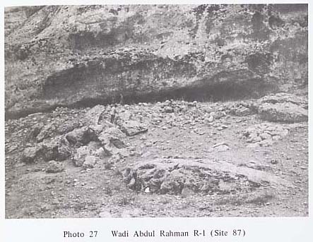
Wadi Abdul Rahman R-l (Site 87)
I. Wadi Abdul Rahman is about 2 km SW of Wadi el Ain. The shelter is on the right bank of the wadi mouth (Fig. 28). II. About 7.5 m higher than the present wadi bed. About 30 m wide at the mouth, about 5 m long. Height of eave is 1 m. The length of the terrace is a few m and it reaches the wadi bottom. The deposits inside the shelter are flat, of superior quality, and generally soft. There is a spot which has been disturbed, along the inner wall, about the middle, 1 square m, 1 m deep. Flints and bones are exposed in the sections. There are big and small rocks all over the terrace (Ph. 27). III. Post-Palaeolithic (Fig. 53:5-9, 11-12).
Wadi Abdul Rahman Open (Site 88)
I. On the bed of Wadi Abdul Rahman (Fig. 28). II. Open site. Isolated from Wadi Abdul Rahman R-1 (Site 87). III. Post-Palaeolithic (Fig. 53:1-2).
Ain es Saheb I (Site 89)
I. On the left bank, upstream of Wadi el Rih, which flows into Barze, about 5 km N of Damas. E of Ain es Saheb. On the right bank of the road leading from Mnine to Halboun. On the middle of the cliff immediately N of the crossroad which leads to Dreij (Fig. 30). II. About 30 m higher than the wadi bed. About 11 m wide in the mouth, and about 20 m long. Height of eave is about 2 m. The opening is surrounded by a stone wall. The widest part of the terrace is about 15 m, about 30 m long. The deposits within the cave slope near the inner wall. Trace of disturbance. III. Post-Palaeolithic.

Ain es Saheb II (Site 90)
I. About 100 m E of Ain es Saheb I (Site 89) (Pig. 30). II. About 19m wide at the mouth and about 10 m long. Height of eave is about 5 m. The cave opening is surrounded by a stone wall. The widest part of the terrace is about 30 m, and about 30 m long. It is possible that a considerable amount of deposit could have been washed from inside the cave. III. Post-Palaeolithic (Fig. 53:3,4,10).
Maaret el Bach Open (Site 91)
I. Marret el Bach is about 10 km N of Yabroud. The area around the wadi which flows in N of this village (Fig. 28). II. There are a few caves on both banks of the wadi, but no deposits were observed. III. Post-Palaeolithic.
Taibe (Site 92)
I. S side and also its E half Taibe hamlet near the border of Syria and Jordan (Fig. 31). II. Open site. III. Post-Palaeolithic (Fig. 53:15).
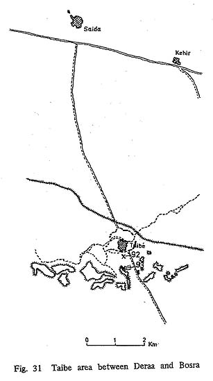
Oumn Semran (Site 93)
I. About 500 m S of Taibe. An area centering around the hill about 20 m high, exposing basalt (Fig. 31). II. Open site. III. Post-Palaeolithic.
Salaat (Site 94)
I. On the right bank of Wadi el Rqaeli (Kaile), upstream of Nahr Kfarie, which flows into the left bank of the upstream of Nahr el Kebir, flowing through Latakia, a sea port of Syria. The opposite bank of Dourine hamlet. A slope above the bridge where the road leading from Salma to Qichbe crosses (Fig. 32). II. Open site. III. Possibly Upper Palaeolithic.

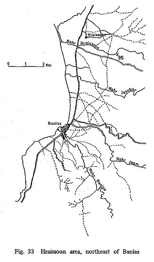
Nahr Hraissoun (Site 95)
I. Field on the left bank of Nahr Hraissoun, where it comes out from a hilly area to alluvial ground. About 3-4 km upstream from wadi mouth (Fig. 33). II. Open site. III. Post-Palaeolithic.
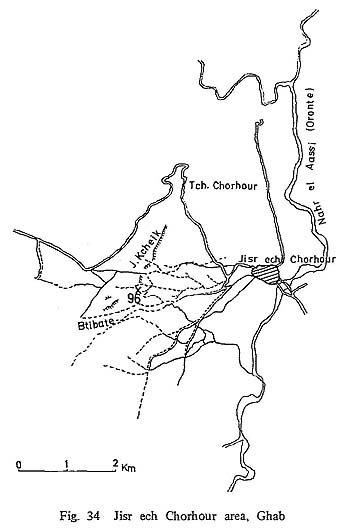
Jebel Kcheik (Site 96)
I. E side of Ghab. About 8 km W of Jisr ech Chorhour. Southern tip of Jebel Kcheik. On the left bank of Wadi Kcheik (Fig. 34). II.Open site, about 70 m higher than the wadi bed. III. Not identified.
Khellale (Site 97)
I. About 6 km E of Latakia. At the spot where the road leading from Latakia to Haffe, along the left bank of Nahr el Kebir, turn to the left (Fig. 35). II. In the gravel bed of terraced hill on the bank, abuot 70 m higher than the river bed. III. Lower Palaeolithic (Fig. 38:3,4). IV. Could be the same one referred to by VAN LIERE (1964:16-19).

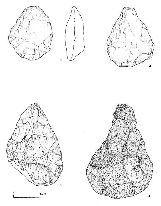
Figure 38 Flint Implements of the Lower Palaeolithic
1. Roughly ovate biface with the butt thinned, heavily abraded. (Mseel, Site 22)
2. Roughly pear-shaped biface with the butt thinned, heavily abraded. (Mseel, Site 22)
3. Roughly pear-shaped biface, heavily abraded. (Khellale, Site 97)
4. Roughly pear-shaped and pointed biface with a large amount of cortex left on both faces of the butt, heavily abraded. (Khellale, Site 97) |
Dahr Souesso Open (Site 98)
I. About 12 km E of Latakia. The road leading from Latakia to Haffe along the left bank of Nahr el Kabir turns to the right at ech Chir. After passing through the hamlets of Khellale and Fidis, a spot at about 120 m altitude overlooking Wadi Saket el Qatrie is reached (Fig. 35). II. On a hill consisting of marine gravel bed. Open site. III. Possibly Middle Palaeolithic (Fig. 42:8).
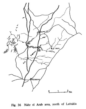
Nahr el Arab (Site 99)
I. About 15 km NNE of Latakia. Going N up the highway between Latakia and Antioch, at about 7 km after passing the crossroad leading to Ugarit site, Nahr el Arab runs W forming a deep eroded valley. This site is just around the bridge which hangs over the river, especially in the gravel bed of the terrace on the left bank. About 60 m above sea level (Fig. 36). II. Open site. III. Pos- sibly Middle Palaeolithic.
|