Keoue (Site 1)
I. About 10 km SSW of Tripoli. Right bank of Wadi Keoue, tributary of Wadi Hab (Wadi el Koura). About 200 m upstream from the spot where the road from Batroumine, about 9 km SSW of Tripoli to Btourram, crosses Wadi Keoue. Altitude about 320 m (Fig. 12). II. About 6 m higher than the bed of Wadi Keoue. Faces approximately NW. Rock shelter type. The center of Shelter is decayed and fallen. The cave overhang forms two wings. Its length 2-3 m, about 3 m high, at the highest point. The terrace has upper and lower stages. The difference between heights of the two stages is about 2 m. The upper stage of the terrace is about 14 m long and 14-15 m wide, and the lower stage, about 12 m long and about 18 m wide. The deposits are found from directly below the cave to all over the two stages of the terrace. The bedrock exposed at west and northwest side of the lower stage continues on to the bedrock exposed in the wadi. Also, in view of the fact the height of the lower stage from the wadi is less than 2 m, deposits of the lower stage cannot be expected to be so rich (Ph. 13). Few flints and bones were scattered around, and a few dozen were collected. Several blocks of breccia containing flints and bones were found on the surface of the terrace. III. Middle Palaeolithic (Fig, 39: 1-6).


Figure 39 Flint Implements of the Middle Palaeolitbic
1. Square-ended Levallois flake-blade with retouched striking-platform. (Keoue, Site 1)
2. Square-ended broad flake with retouched striking-platform. (Keoue, Site 1)
3. Roughly triangular Levallois flake. (Keoue, Site 1)
4. Square-ended Lavellois flake-blade with retouched striking-platform. (Keoue, Site 1)
5. Point on a small triangular Levallois flake with retouched striking-platform. (Keoue, Site 1)
6. Unifacial point with the bulbar face retouched. (Keoue, Site 1)
7. Levallois flake-blade with retouched striking-platform, broken. (El Qareb, Site 5)
8. Side scraper on broad Levallois flake. (El Qareb, Site 5)
9. Flake scraper on broad Levallois flake. (El Qareb, Site 5)
10. End-scraper on Levallois flake-blade with small faceted striking-platform. (El Qareb, Site 5)
11. Square-ended Levallois flake-blade with small faceted striking-platform. (El Qareb, Site 5)
12. Point on small flake-blade with faceted striking-platform. (El Qareb, Site 5)
13. Point on small flake-blade with faceted striking-platform. (El Qareb, Site 5)
14. Blade. (El Qareb, Site 5
15. Blade. (El Qareb, Site 5)
16. Flake-blade with small retouched striking-platform. (El Qareb, Site 5)
17. Flake-blade with plain striking-platform. (El Qareb, Site 5) |
Wadi Keoue (Site 2)
I. About 100 m downstream from Keoue site (Site 1), on the bed of Wadi Keoue (Fig. 12). II. Open site. Since it is a river bed, it is not suitable to regard it as a site. Considered to be the flints washed out of Keoue site (Site 1). This is sub-stantiated by the fact that flints were found only downstream from the Keoue site. Very few complete flint implements. The physical condition of the flints, such as patina, is similar to that found at Keoue site (Site 1). III. Middle Palaeolithic.
Wadi Aarab (Site 3)
I. About 20 km southwest of Tripoli. A few small caves in a row from the middle to downstream of Wadi Aarab, which flows from the plateau of Ras ech Chaqaa (Fig. 13). II. All are small caves, each faces approximately east. Very few flints. Flints were collected also on the wadi bed. III. Possibly Middle Palaeolithic.

Mazrat Hannouch I(Site 4)
I. About 300 m N from the wadi mouth of Wadi es Souri, which runs about 7 km N of Nahr el Jaouz, which flows to N of Batroun. NW of N exit of a tunnel of Beirut-Tripoli Railway. A saltern can be seen 20 m below (Fig. 13). II. Presumed to be a rock shelter once, but has lost its original shape due to extreme weathering. Flints are scanty. III. Not indentified.
El Qareb (Site 5)
I. About 3 km N of Batroun, W of Selaata. On E cliff along Beirut-Tripoli Railway (Fig. 13). II. Consists of two shelters facing each other. Near the Junction of the two shelters, there is a big rock, which is presumed to have formed a part of the eave (Ph. 14). The height of existing shelter is 2-4 m. A part of the terrace is cut by the railroad. The length of the remaining terrace is 5-7 m, and the maximum width is about 20 m. The difference of height between the terrace and the railroad is about 2.5 m. The deposits can be seen at the place cut by the railroad. They are divided into upper and lower layers, the lower layer having become completely concreted. The upper layer has not done so and is soft. Flints and bones are found in the lower concretion. They are also considerably scattered around the ground surface. III. Middle Palaeolithic (Fig. 39: 7-17).

Koubba II (Site 6)
I Right bank and at the mouth of Nahr el Jaouz. About 200 m SW of Koubba. Coming from Beirut, crossing the bridge on the Nahr el Jaouz, and shortly after turning left into a bypath at about 80 m N of the bridge, the group of caves can be seen on the right bank. Deposits are found in the second, third and fourth caves counting from the eastern end of the group. These are called Koubba II as a whole, and from east, II-1, II-2, and II-3 individually (Fig. 14). II. The caves II-l and II-2 are small, but II-3 is quite large. Hardly any deposits occur in any of these three caves, but on the wide terrace of about 30 m width and about 10 m length, they are found. All over the terrace, several extremely hard brecciated, big and small blocks, are recognized, which contain flints and bones. The biggest of them is 6 × 10 m and 1 - 1.5 m thick as far as its exposed part is concerned. Soft deposits are recognized in the remaining part. The flat place of the terrace is about 10 m long, and after that it slants sharply toward the bypath. There is about 18.5 m difference in height from the top of the terrace to the bypath. There are many flints and bones contained in the breccia, but very few remains scattered independently (Ph. 15). III. Upper Palaeolithic (Fig. 43: 1-15). IV. Discovered by ZUMOFFEN (1900, 1908), and a few other researchers have referred to this site (KARGE, 1917, WETZEL & HALLER, 1945, COPELAND and WESCOMBE, 1965). Reported as of Middle Palaeolithic before, but among the flints we collected there were very few of that classification; the majority are of Upper Palaeolithic.


Figure 43 Flint Implements of the Upper Palaeolithic
1. Graver on flake-blade with small retouched striking-platform. (Koubba II, Site 6)
2. Graver on blade nibbled on the right edge. (Koubba II, Site 6)
3. Angle graver. (Koubba II, Site 6)
4. Graver (bec-de-flûte) on blade with small faceted striking-platform. (Koubba II, Site 6)
5. End scraper. (Koubba II, Site 6)
6. Blunted-back blade. (Koubba II, Site 6)
7. Backed blade. (Koubba II, Site 6)
8. Blade nibbled on both edges. (Koubba II, Site 6)
9. Blade with small faceted striking-platform. (Koubba II, Site 6)
10. Blade with small faceted striking-platform. (Koubba II, Site 6)
11. Blade. (Koubba II, Site 6)
12. End scraper on blade. (Koubba II, Site 6)
13. Backed blade. (Koubba II, Site 6)
14. Blade. (Koubba II, Site 6)
15. Blade core. (Koubba II, Site 6) |
Mar Sabour (Site 7)
I. About 1.5 km N of Batroun. Right bank and near the mouth of Nahr el Jaouz. Near the hamlet of Koubba, About 60 m E of Beirut-Tripoli road (Fig. 14). II. This is a cave made in the bedding plane of sediments, formed on a cliff presumed to be the terrace deposit of Nahr el Jaouz. In front of it there is a short terrace of 2-3 m length, which is under cultivation at present. Flints are scattered both inside and outside the cave. There were only a few in number; some potsherds were collected. The relationship between the flints and the pottery is not clear. III. Post-Palaeolithic (Fig. 46: 1-3).

Figure 46 Flint Implements of the Post-Palaeolithic
1. Bifacial axe. (Mar Sabour, Site 7)
2. Blunted-back blade. (Mar Sabour, Site 7)
3. Broken arrowhead with short, broad tang, (Mar Sabour, Site 7)
4. Short thick blade, and retouched into an end-scraper. (Jdayel Open, Site 11)
5. Sickle blade. (Wadi Edde I, Site 12)
6. Notched element on thick flake. (Mugharet es Stouh (South), Site 9)
7. Point on heavy, thick flake, (Mugharet es Stouh (South), Site 9)
8. Scraper on blunted-back flake. (Mugharet es Stouh (South), Site 9)
9. Large Levallois core. (Mugharet es Stouh (North), Site 8)
10. Notched flake with retouched striking-platform. (Mugharet es Stouh (North), Site 8)
11. Scraper on thick flake with retouched striking-platform. (Mugharet es Stouh (North), Site 8)
12. Scraper on flake of Levallois technique, (Mugharet es Stouh (North), Site 8) |
Mugharet es Stouh (North) (Site 8)
I. About 850 m NNE of Batroun. East side of Beirut-Tripoli road. About 340 m NE of a Beirut-Tripoli Railroad crossing. About 13 m high, in the northern side of es Stouh hamlet (Fig. 14). II. A series of small caves on the cliff presumed to be gravel beds. The terrace, 30-50 m length, is being used as a terraced farm. Flints are mainly scattered on the farm. III. Post-Palaeolithic (Fig. 46: 9-12).
Mugharet es Stouh (South) (Site 9)
I. Similarly situated as Mugharet es Stouh (North) (Site 8), but southerly by a few dozen meters (Fig. 14). II. Looks similar to Mugharet es Stouh (North). Flints are mainly scattered on the cultivated field. III. Post-Palaeolithic (Fig. 46: 6-8). IV. It is possible that this is the same with Batroun I site already reported (COPELAND & WESCOMBE, 1965:71). Still open to confirmation.
Deir Mar Yusef (Site 10)
I. About 600 m NE of Batroun. At the west end of Deir Mar Yusef hamlet. On both sides of the road between Deir Mar Yusef and Es Stouh (Fig. 14). II. Open site. A great quantity of scattered flints. Very few complete implement; the majority are cores, and incomplete and broken flint implements. III. Not identified.
Jdayel Open (Site 11)
I. Cultivated field around the source of Wadi Rabib, about 5 km N of Jbail. The field is on the left side of the road from Beaachta to Moussef, immediately after it passes Jdayel (Fig. 15). II. Open site. A grear quantity of scattered flints. Very few complete implements. III. Post-Palaeolithic (Fig. 46: 4).

Wadi Edde I (Site 12)
I. About 1 km N of Jbail. On the right bank of Wadi Edde, about 200 m downstream from bridge of the Beirut-Tripoli road (Fig. 15). II. A small caveabout 8 m above the wadi bed. In front of the cave there is a wide terrace being used as a terraced field. Very few scattered flints. III. Post-Palaeolithic (Pig. 46: 5).
Ehmej Open (Site 13)
I. About 2 km N of Ehmej hamlet, about 12 km E of Jbail (Fig. 16). II. Open site in a cultivated field. III. Not identified.

Mugharet el Asfurieh (upper site) (Site 14)
I. Situated to E of the cave site which has been reported as Nahr Ibrahim or Mugharet el Asfurieh (COPELAND and WESCOMBE, 1965:111) (Ph. 17). The site is mainly a terrace about 10 m higher than the latter (Fig. 17). II. The site consists of an indeterminate shaped terrace, 30 × 40 m big, and a cliff about 2.5 m high at the southern end of the terrace, facing N. At the bottom of the cliffs there is a 20-30 cm wide crevice, extending to the inside. Further examination is required to determine whether this crevice is a cave or a shelter which is almost buried by deposits or merely a crevice made in the rock (Ph. 18). A great quantity of flints are scattered on the terrace, including many complete flint implements. However, compared with those discovered at the so-called Nahr Ibrahim site (Mugharet el Asfurieh), not only are they smaller in number but the flint implements themselves are mostly rough. III. Middle Palaeolithic (Fig. 40: 1-4). IV. This is a site neighboring on the so-called Nahr Ibrahim site (Mugharet el Asfurieh) and the cliffs are clearly its continuation. Therefore, even though there has been no mention of this site in the previous reports (COPELAND and WESCOMBE, 1965:111 and others), this might be regarded as the same site.

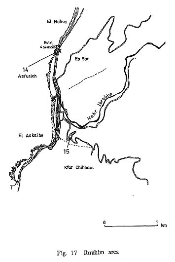


Figure 40 Flint Implements of the Middle Palaeolithic
1. Roughly triangular point on Levallois flake with a retouched striking-platform. (Mugharet el Asfurieh, upper site, Site 14)
2. Notched element on long blade with a large amount of cortex left on the upper face. (Mugharet el Asfurieh, upper site, Site 14)
3. Notched element on thick Levallois flake with retouched striking-platform. (Mugharet el Asfurieh, upper site, Site 14)
4. Notched element on Levallois flake, retouched on the lower face. (Mugharet el Asfurieh upper site, Site 14)
5. Square-ended Levallois flake-blade, the striking-platform removed by chipping from the upper face. (Es Souass Shelter, Site 17)
6. Levallois flake-blade with retouched striking-platform. (Es Souass Shelter, Site 17)
7. Triangular point on Levallois flake with faceted striking-platform. (Es Souass Shelter, Site 17)
8. Notched element on roughly triangular Levallois flake with faceted striking-platform, (Es Souass Shelter, Site 17)
9. Side scraper on roughly triangular Levallois flake, the striking-platform removed by chipping from the upper face. (Es Souass Shelter, Site 17)
10. Notched element on elongated Levallois flake-blade with retouched striking-platform and retouched into an end-scraper, (Es Souass Shelter, Site 17)
11. Scraper on broad Levallois flake with retouched striking-platform, broken. (Es Souass Shelter, Site 17)
12. Double ended flake core with retouched striking-platform. (Es Souass Shelter, Site 17)
13. Single ended flake-blade core. (Es Souass Shelter, Site 17) |
Adonis Achtrout (Site 15)
I. About 7 km of Jbail. On the mouth of the Nahr Ibrahim. About 300 m E of Aaqaibe. About 100 m from the first curve on the road climbing to Bqaq ed Dine (Fig. 17). II. Cave faces approximately W. The width of opening is about 13 m and length about 17 m, height about 2.5 m. Inside deposits slope toward the inner wall. Presumed to have been disturbed. The widest part of the terrace is about 14 m, the length about 15m. At present a house is constructed on it and nearly two third of the whole area is under the house. Furthermore, the front end of the terrace is cut by the road. Rather hard breccia containing flints and bones may be seen in the terrace. Few flints implements. III. Possibly Middle Palaeolithic.
Mugharet el Hainmam (Site 16)
I. Cave on the left bank about 500 m upstream of Nahr el Hammam, a tributary flowing into the left bank of Nahr ed Damour, about 3 km upstream. Upper part of the cave can be observed from the path which goes along the right bank from the turning point. Altitude about 80-90 m (Fig. 18). II. About 14 m high from the bottom of the wadi. Faces approximately NE. Maximum width about 15m, 6-9 m length. Asymmetrical semi-oval (Ph. 19). The terrace is divided into two parts of different height by a stone wall. The flat place of the higher part is about 15 m in maximum width and about 4 m in length short and wide rectangular shape. Along the stone wall there is a narrow lane below which the terrace slopes sharply to the bottom of the wadi. Deposits are either black or brownish black. Contains charcoal grain, sand grain, small angular pebbles. Dry and soft. The cave shows traces of having been used as a charcoal burning works at one time. Along the inner wall of the cave, breccia containing flints and bones adheres in places. Presumed that a part of the deposits was scraped off. Flints and bones are scattered in great quantity both inside and outside the cave. III. Upper Palaeolithic (Fig. 44: 1-13).

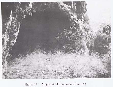

Figure 44 Flint Implements of the Upper Palaeolithic
1. Angle graver on elongated blade, cortex left on the right side of the upper face. (Mugharet el Hammam, Site 16)
2. Graver on flake. (Mugharet el Hammam, Site 16)
3. Graver on blade. (Mugharet el Hammam, Site 16)
4. Graver on blade. (Mugharet el Hammam, Site 16)
5. Notched blade. (Mugharet el Hammam, Site 16)
6. Blade. (Mugharet el Hammam, Site 16)
7. Blade. (Mugharet el Hammam, Site 16)
8. Bladelet. (Mugharet el Hammam, Site 16)
9. Bladelet. (Mugharet el Hammam, Site 16)
10. Steep scraper. (Mugharet el Hammam, Site 16)
11. Steep scraper. (Mugharet el Hammam, Site 16)
12. Blade core. (Mugharet el Hammam, Site 16)
13. Bone fragment. (Mugharet el Hammam, Site 16) |
Es Souass Shelter (Site 17)
I. On the right bank of the Saqiet es Souass, and upstream part of Nahr Maci (Wadi Qassouba) about 5 km S of Nahr ed Damour. It enters the Nahr Maci's right bank about 4.5 km upstream. The site is about 300 m upstream from the point where the tributary enters the main stream. Altitude about 200 m (Fig. 19). II. Shelter about 10 m higher than the wadi. The greatest width about 12 m. Length about 5 m. Faces approximately E. The terrace has several steps edged by stone walls. The uppermost one to the first stone wall, the main part of the terrace, is almost flat with a length of about 4.5 m. From there it slopes sharply to reach the bottom of the wadi. Hardly any deposit is noticed in the shelter. Flints and bones adhere to the bedrock in several places. A great quantity of flints and bones are adhered to the inner wall about 4 m high. From this evidence it is presumed that a great quantity of deposit has been dug out already. All over the terrace is scattered a great quantity of flints, and breccia is being utilized to form a part of the stone wall, also proving that the deposits have been disturbed in the past (Ph. 16). III. Middle Palaeolithic (Fig. 40: 5-13).


Wadi Daher (Site 18)
I. On the E slope of the Lebanon Mountains. At Qabb Elias, about 2 km S of the spot immediately after the Beirut-Damas road enters Bekka Valley. On top of the mountain range between Wadi ed Dahr and Wadi Mathar, which runs almost from E-W in the N and S sides of Qabb Elias. About 70 m higher than the bottom of Wadi Mather (Fig. 20). II. Open Site. III. Not indentified.

Aita ez Zoutt (Site 19)
I. About 22 km SE of Tyre. About 1 km NW of Aita ez Zoutt. Below the right side of the road which leads from Aita ez Zoutt to Tyre, immediately after it passes Haddasse (Fig. 21). II. Cave. About 6 m wide and 10 m long. Artificial working, said to be of Byzantine age (from oral communication), found on the wall and floor. The terrace of the cave is turned into a terraced farm. Flints and bones are scattered both inside and outside the cave. Some potsherds are also scattered around. III. Post-Palaeolithic.

Hanaouiye 3 (Site 20)
I. Approximately between Site Hanaouiye I and II, already discovered (COPELAND and WESCOMBE, 1966: 31-32) (Fig. 22). II. About 10 m maximum width. About 1 m long. III. Middle Palaeolithic. IV. Close to the site reported as Hanaouiye I. Presumed that researchers in the past have visited here, but no mention has been made of it; therefore, it is reported here.

Hanaouiye 4 (Site 21)
I. Next to the group of Hanaouiye sites, to S of them (Fig. 22). II. Open site. A few complete flint implements. III. Middle Palaeolithic.
Mseel (Site 22)
I. About 5 km WNW of Ain Ebel. All over the wadi bed a few km upstream of Wadi Ayun (Fig. 21). Mseel is the general name for all of the wadi area (from oral communication). II. Since it was a wadi bed, it cannot be regarded as a living site. Flint implements were collected from among the round pebbles on the wadi bed. Presumed to have been washed here from somewhere. III. Lower Palaeolithic (Fig. 38: 1,2).
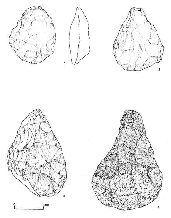
Figure 38 Flint Implements of the Lower Palaeolithic
1. Roughly ovate biface with the butt thinned, heavily abraded. (Mseel, Site 22)
2. Roughly pear-shaped biface with the butt thinned, heavily abraded. (Mseel, Site 22)
3. Roughly pear-shaped biface, heavily abraded. (Khellale, Site 97)
4. Roughly pear-shaped and pointed biface with a large amount of cortex left on both faces of the butt, heavily abraded. (Khellale, Site 97) |
Mugharet el Abed (Site 23)
I. About 20 km SE of Tyre. Middle of left bank, about 1 km upstream of Wadi Ayun. About 1.5 km downstream from Debel. About 550 m altitude (Fig.21). II. Small cave at about 50 m from the bed of Wadi Ayun, facing NE. The widest part of the cave mouth is about 8.5 m. 3-4 m long (Ph. 20). The terrace is cut into several steps by stone walls. For about 2-3 m from the cave the terrace is flat. Below the terrace, two steps of stone walls, 2-3 m high. Then terraced olive- fields. Deposits are observed inside and outside the cave, but near the inner wall of the cave are traces of its having been disturbed. A few big rocks in front of the cave. Not clear if they are bedrocks or not. III. Upper Palaeolithic (Fig. 45: 1-15). IV. Discovered by KARGE (1909-1911), and a few other researchers refer to the cave (TURVILLE-PETRE, 1927, NASRALLAH, 1948, HOURS, 1965, WESCOMBE, 1966: 47).


Figure 45 Flint Implements of the Upper Palaeolithic
1. Core and possibly reused as scraper. (Mugharet el Abed, Site 23)
2. Scraper on Levallois flake with faceted striking-platform. (Mugharet el Abed, Site 23)
3. Scraper with notched element on Levallois flake with a retouched striking-platform. Mugharet el Abed, Site 23)
4. Graver on blade. (Mugharet el Abed, Site 23)
5. Graver on blade. (Mugharet el Abed, Site 23)
6. Graver. (Mugharet el Abed, Site 23)
7. Blade. (Mugharet el Abed, Site 23)
8. Utilized flake-blade, broken. (Mugharet el Abed, Site 23)
9. Utilized flake. (Mugharet el Abed, Site 23)
10. Blade nibbled on the left edge. (Mugharet el Abed, Site 23)
11. Double end-scraper. (Mugharet el Abed, Site 23)
12. Steep scraper. (Mugharet el Abed, Site 23)
13. Steep scraper. (Mugharet el Abed, Site 23)
14. Steep scraper, (Mugharet el Abed, Site 23)
15. Core, (Mugharet el Abed, Site 23) |
Nahr el Hasbani (Site 24)
I. About 4 km of Marjayoun. About 300-800 m E of Ebel es Saqi. Middle of the slope on the right bank of Nahr el Hasbani (Fig. 23). II. Open site. Few flints. III. Not identified.

|