CHAPTER I GEOGRAPHICAL NOTE
3. Outline of Topography and Geology of Syria
|
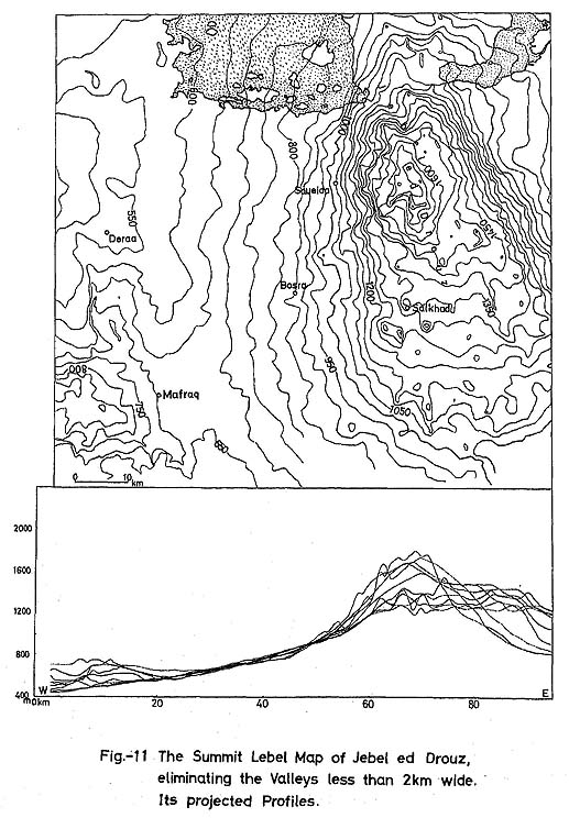
The topography of Syria can be roughly divided into Jebel Ansarieh, the mountainous area 1,200 to 1,500 m high which starts from Hatay region, in the south of Turkey and runs in a S-N direction, the 1,500 to 2,800 m high Anti-Lebanon Mountains etc., and the plateau which develops in the east of these mountainous areas. Jebel Ansarieh runs south to north, in the west of Ghab, which continues from Bekka Valley, and is separated from the Lebanon Mountains by the Tripoli-Homs depression, but its topographical characteristics are similar to those of the Lebanon Mountains, i.e., its extreme eastern part is the main ridge, and its western slope is gentle, while its eastern slope declines sharply to the Ghab swamp with a 1,300 m cliff. Anti-Lebanon Mountains, which runs parallel to the Lebanon Mountains, are 25 to 30 km wide, and about 140 km long. With Mt, Hermon in its southernmost part as the highest peak, the mountains decrease in height as they stretch to the northeast, continuing on to the south of Homs. The plateau is not necessarily flat all over, but is quite varied in topography. First of all, Jebel ed Drouz, near the border of Jordan, is a mountain rising to a height of 1,700 m, as shown in Fig. 11, and consists of volcanic cones. Basalt flow is widespread over the plateau and reached Rift valley, running down Yarmouk valley. The mountains called Palmyrides branch out from the Anti-Lebanon Mountains near Dmeir, east of Damascus, maintaining a 1,000 to 1,300 m altitude, and pass Palmyra, situated in the center of the Syrian desert, continuing on to Jebel al Bichri, near the Euphrates. The area along the north bank of the Euphrates is called the Jezire region. Nahr el Balikh at Raqqa, and the Nahr el Khabour at southeast of Deir ez Zor, join the Euphrates. The area consists of rolling terrain with not much undulation. Only Jebel Aabd el Aaziz is 700 to 900 m high and breaks the monotony. It is the Orontes which flows north along the boundary of the western mountains and plateau, having its source in Bekka Valley. Passing Homs, Hama, Ghab and the territory of Turkey, it enters the Mediterranean.
The geology of this area is approximately as follows: The western mountains consist of Pre-Cambrian - Palaeozoic rocks, Jurassic limestone, marl, dolomite and gypsum. These rocks are exposed as a part of the Palmyrides, especially around Palmyra. The thickness of the system is said to reach 1,600 m. Folded Cretaceous rocks, accompanied with fault, form Jebel Ansarieh and the Palmyrides, are distributed also in the north of Jebel Aabd el Aaziz. The structure of Anti-Lebanon Mountain System, Palmyrides and Jebel Ansarieh, etc. were largely formed by orogenic movement started at the end of the Cretaceous. Block movement became predominant in the Eocene. At this time, transgression occurred over and extensive area, and limestone, clay and sandstone were deposited. It is said that at some places these sedimentary rocks reach the thickness 350 m. During the Miocene and Pliocene, orogenic movement, accompanied by volcanic activity, became intense, and transgression occurred over an extensive area, but at the end of the Pliocene, the topography assumed almost its present condition. Especially is this true for the sedimentary rocks of the Miocene which can be seen in the center of the Syrian desert, but Pliocene sediments are distributed only along the Euphrates and the valleys along the Nahr el Kebir. Volcanic activity was repeated at Jebel ed Drouz in the Pleistocene, and as a result, the some basalt flow reached as far as about 20 km south of Damascus, and flowed down as far as the Rift Valley. In the coastal area, because of changes in the sea level, 5 to 6 marine terraces were formed, and in the inland drainage basins, because of changes in base level, river terraces were formed on a small scale. As their deposits in the surrounding area vary extremely, it is very difficult to compare these two areas. |