CHAPTER I GEOGRAPHICAL NOTE
2. Topography of the Area Surveyed in Lebanon
|
Since our object was the discovery of cave sites, we eliminated the areas which we could foresee would not yield well formed caves after we read topographical and geological maps. These were areas as the northern part of Bekka Valley, main ridge of the Lebanon Mountains, and also the areas where urbanization progressed such as Beirut, Tripoli, and the border areas (south of the Litani River, most of the southern part of Bekka Valley, north of Tripoli, and Anti-Lebanon Mountains). Instead, the areas were surveyed which are described below. 1) Mediterranean Slope(a) Near TripoliSeveral coastal terraces are developed in the downstream area of Nahr el Bared to the north of Tripoli, around Jabal Tourbol, 600 m high. This area was observed through the car window, from the dam site of Nahr el Bared to its downstream area, from Ras Lados to the northern foot of Jabal Tourbol, and up to the neighbourhood of Aachach in the southern foot of Jabal Tourbol. Jabal Tourbol, which consists of Miocene limestone overlay unconformably Senomanien limestone rises from the coastal plain, but caves have not been formed very much, Nahr Abou Alt, having its source at Cedrés running in a northwesterly direction, forms a deep eroded, unapproachable valley (Ph. 1). However, near Kousba, the difference in height between the valley bottom and the broad lowland is 200 m, and the valley becomes shallower in the downstream area, so that centering around that area, its tributaries, Wadi Nbouch. Nahr Joueit, Nahr Rachaain, were investigated on foot, but on cave sites were found. Although caves are well formed along the Nahr el Bared, from the coast up to Wadi Keoue, the height from the river bed is small, and very few caves have any deposits. The only exception is Site No. 1 at the source of Wadi Keoue, east of Fiaa. Wadi Abou Halka, its upstream, Wadi Mar Yaaqoub, Wadi Klila, and Wadi Nakhle were investigated, but no cave site which had deposits was discovered.
(b) Wadi Abou Halka ——— Ras ech ChaqaaThis area, since the mountains around Ras ech Chaqaa consist of Senomanien fragile clayey limestone, presents the so-called badland topography. Although drainage density is great, the valley wall is covered by talus and is convex in form; therefore cave formation is extremely poor. Our investigation was limited to the terrace scarp near Enfe, and small wadis which cross the mountainous area between Wadi Abou Halka and Enfe, consisting of Miocene limestone. Cave formation around Enfe is considerably better, presenting a few open sites, but there are hardly any cave sites which have a thick deposit.(c) Ras ech Chaqaa ——— BatrounRas ech Chaqaa Karst plateau, consisting of Miocene limestone, laid unconformably over Senomanien limestone, is extremely flat, about 200 m high, and three wadis run to the west. The Senomanien clayey limestone at the lower part of the plateau is fragile, so that the end of the plateau becomes a steep cliff, and in some places it even overhangs. In this area, investigation was made along the eroded valley which crosses the plateau mentioned above, the seaward slope from Beirut-Tripoli road, and the area from Ras ech Chaqaa, Hannouch, Selaata, to the mouth of Nahr el Jaouz. Several cave sites and open sites were discovered, and investigation was made in detail on the cave sites of Koubba's terrace scarp, already reported. The terrace scarp at a height of 20 to 30 m, east of the road, Mar Sabour and east of Batroun, was investigated, and new open sites and cave sites were discovered (Ph. 2). Along the Nahr el Jaouz, Kaftoun, on the right bank, the area near Deir Billa and Hai el Qarn, the area near Douma and a tributary of Nahr Kour, the neighbourhood of Tartej, were investigated. The valley is deep, and no prehistoric site was discovered, although caves were- well formed.
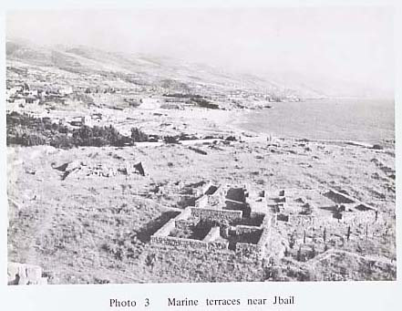
(d) South of Batroun, around JbailNear Bijdarfel, upstream of Wadi Eddé, which flows west eroding the mountainous area consisting of folded limestone and marl of Cenomanien and Turonien, and the drainage basin of Nahr Madfoun were investigated. Near Jbail, many wadis of area from Wadi Heloue to Nahr Ibrahim, Wadi Heloue, Wadi Rabib, Nahr Beaachta, Wadi Nebaa, Wadi Aamchit, Wadi Eddé, Wadi Joura, Wadi Mehrine, Wadi ed Dargé, Nahr el Fidar, a small wadi near Halat, and Nahr Ibrahim were investigated, from the river mouths to the upstream areas (Ph. 3). Generally there are very few caves, although the area from Wadi Heloue to Wadi ed Dargé exposes Turonien rocks, and the wadi itself is well developed. There is much vegetation on the coastal slope, hindering our investigation.
(e) Nahr Ibrahim ——— BeirutThis area along Beirut ——— Tripoli road was mainly observed from the car window. Such prehistoric sites as Ras el Kelb, Ksar 'Akil, and Jaita, which had been already discovered, were visited. Investigation was done only near Ghazir and Rachine. Although it was presumed that caves for sites would have been well formed, because of the distribution of sites already discovered and of developed wadis, the area remains uninvestigated due to limits on our time.(f) Damour ——— Jiye AreaNahr Abou Damaa, which flows into the town of Damour, has its source on the mountain on which the town of Aabey, 900 m high rests. The area along the valley up to Trila was investigated on foot, but no caves and shelters with deposits and flint implements were found. Near the Nahr ed Damour a cave site, including flint implements and animal bones, was found on the left bank of Nahr el Hammam. The upstream area of Nahr el Hammam, and its main stream, Nahr ed Damour, remains uninvestigated since its valley wall is so steep. South of Nahr ed Damour lies one of the area most carefully investigated, since Mugharet ej Jiye had been discovered by Father Hours. Wadi Jaouamis, Nahr Maci, small wadis around Jiye, Wadi el Houe, Wadi ez Zeini, etc. were investigated. Caves are particularly well formed along Nahr Maci, where Mugharet ej Jiye is. A new shelter, which we call es Souass, was discovered upstream. The valley wall of Wadi ez Zeini is clayey limestone, and the formation of the cave is poor.(g) Around Saida, South of the River LitaniSouth of Nahr el Aouali, as is clear from Fig. 2, consists of a hill whose flat surfaces are relatively well preserved. The land surfaces can be roughly divided into 400 m, 300 m, and 150 m levels. Geologically, it consists of Eocene limestone, continuing from the Palestine hills. However, since around Wadi Qlait Khallet Chaaya and Nahr el Aouali consist of clayey limestone, cave formation is poor. There are many military zones in the coastal area south of Saida, and only the Adioun caves, which have been already reported, were visited. The drainage basin of the Litani and the area to its south are military zones and semi-military zones.Since there are many already reported open and cave sites, we investigated them after special permission was obtained. Therefore, because of the time limit, only Wadi Aaziz and Wadi Safa near Khallet Khazen, Nahr el Hasbani, Wadi Ayun were investigated, and other area were merely observed.
2) Bekka Valley(h) Around BaalbekBekka Valley, which is a graben, is extremely flat (Ph. 5). Both the Lebanon and the Anti-Lebanon Mountains show geological structure slanting respectively west and east, and are the borders of the Bekka Valley with the fault system running in NNE - SSW direction. Therefore, reflecting this geological structure, the valley which flows into Bekka Valley is not very well developed. An area near Baalbek was one of the areas most carefully investigated. The area along the Wadi Nahle was investigated, from northeast of Maqne where the wadi disappears, to Nahle where the wadi enters into Bekka Valley from Anti-Lebanon Mountains. But the valley, which penetrates the Senonien - Eocene rocks, does not have well-formed caves. An area, where terrestrial sediments in Pliocene overlie unconformably them has developed caves. The area surrounding Baalbek, especially Tell el Abyad, east of Yaate, and Wadi Jerbane, were investigated. After observing Deir el Ahmar and Yammoune area in the Lebanon Mountains, it was found that cave formation was poor, except Wadi en Nsour, north of El Yammoune and Ainata, which has well formed caves. Detailed investigation on this wadi not done because of the limit on time.
(i) Qabb Elias ——— ZahleThe area west of Bekka Valley, Wadi ed Daher, upstream of Nahr Qabb Elias, which flows through the town of Qabb Elias, and Wadi Mather were investigated. Despite the fact that cave formation is good, no cave sites with deposits were discovered. West of Chtaura is a hanging valley, with fault scarp, and no caves were discovered. Nahr el Berdaouni, which flows into Zahle, Dahr el Mogher, along Wadi el Slailim, and Ain Zlakette, 5 km northeast of Zahle, were investigated. Although artificial caves, said to be Roman tombs, could be seen, no Palaeolithic sites were discovered. |