CHAPTER 1
Paleoenvironments in Palmyra District during the Late Quaternary
Yutaka Sakaguchi
|
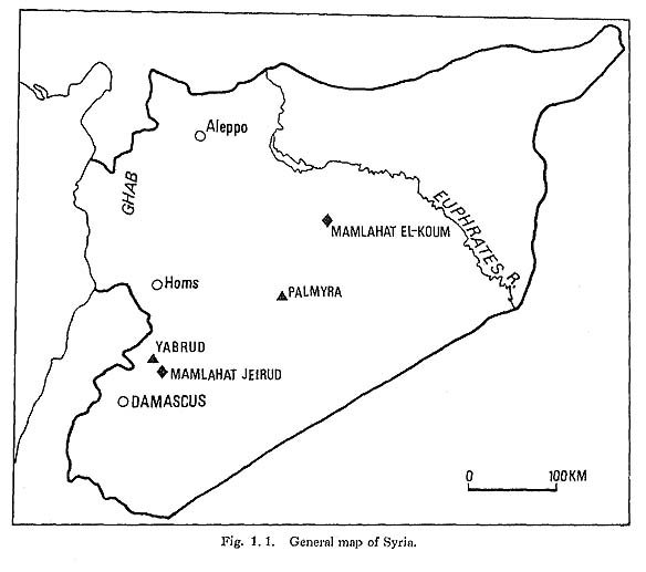
 Fig.1.2 |
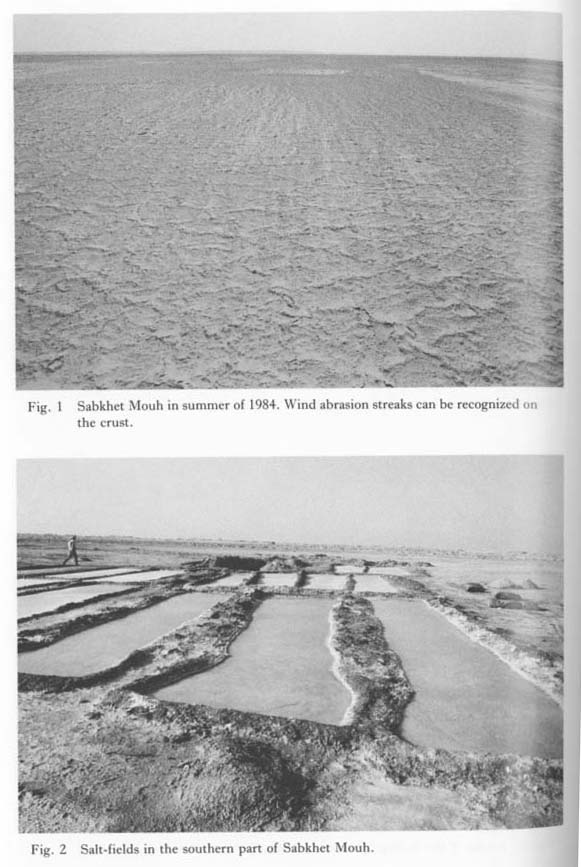 Plate1.26 |
The mean annual precipitation in Palmyra is 125 mm, but there is considerable variability. The large amount of precipitation during the rainy season of 1973/74 (270 mm from Oct. 1973 to Apr. 1974) formed a playa lake which occupied Sabkhet Mouh during our 1974 season's excavation. This lake is called the Lake of 1974. The elevation of its highest water level was 377 m above sea level.
Douara Cave, in which artifacts have been found dating from the Middle Paleolithic to the Epi-Palcolithic, was formed in Paleogcne limestones on the southern flank of Jabal Ad-Dawwara (Douara). Jabal Ad-Dawwara is a horseshoe-shaped range of mountains, which opens toward the east. These mountains enclose a basin that is called the Douara Basin. In the basin pediments and terraces are developed and we can find many flint factory sites from the Lower Paleolithic to the Neolithic in addition to flint-strewn fields (Fig. 1, 3; Plate 1.7:1).
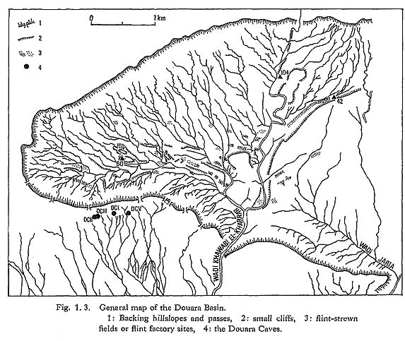
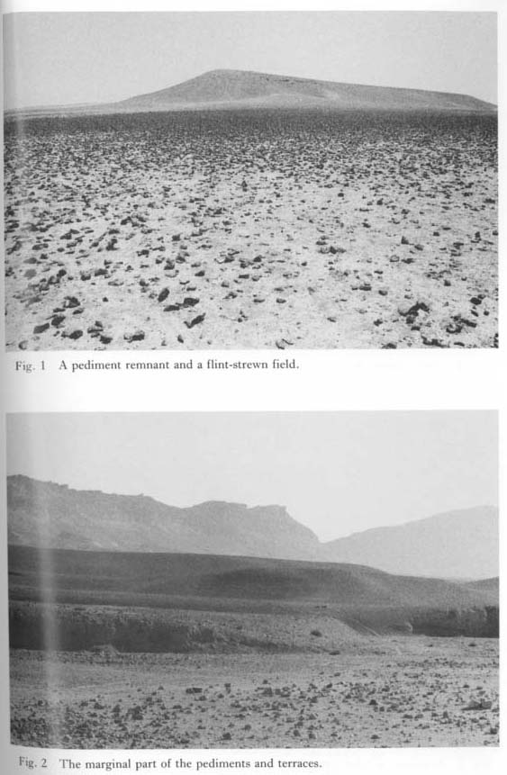 Plate 1.7 |
In the report of the fifth expedition of 1974 the author concluded that the Palmyra Basin was occupied by a lake of about 510 km2 since at least 45,000 BP, with a water level elevation of 397 m in 19,000 BP (Sakaguchi, 1978a). This lake was called the Palmyra Pluvial Lake, stage A. Palmyra Pluvial Lake, stage B, was inferred to have existed in the period 10,000-8,000 BP with a water level of 383 m.
The purpose of the author's investigations during the sixth expedition (June to September of 1984) was to collect further evidence concerning these paleolakes and to reconstruct their paleoenvironments. In the present paper the author also discusses the pediments in the Douara Basin, whose geomorphological features were addressed by Koizumi in the previous report.
1.2 PEDIMENTS
1.2.1 Pediments in the Douara Basin
The Douara Basin was formed by the erosion of Wadi Khawabi El-Kharrar and Wadi Jaria, along the axis of a Paleogene limestone dome structure. As seen in Plate 1.1: 1-2, pediments cut by V-shaped valleys have developed on the basin floor. The upper and lower parts of the backing hillslopes are formed of Eocene limestones and Paleocene Eocene marls, respectively (Fig. 1.11). This relationship is common for all of the backing hillslopes around the basin. The basin floor is marls. The same barite nodules found in the hearth deposit of Douara Cave I occur in the marls near Locality 60 (Plate 1.8: 1).
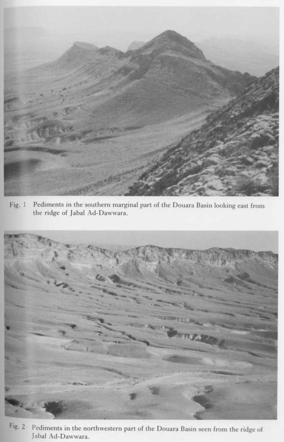 Plate 1.1 |
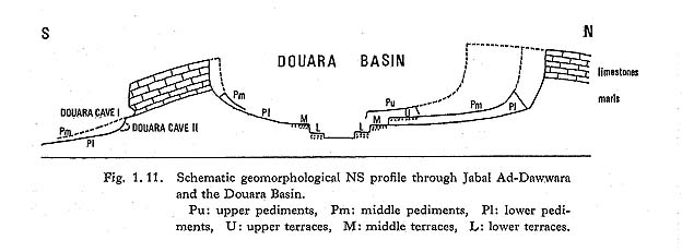
 Plate 1.8 |
The pediments are divided into higher and lower ones whose gradients at the head are different (Plate 1.1: 1-2). The backing hillslopes facing north have no talus at their feet (Plate 1.2: 1), while the lower halves of the backing hillslopes facing south are covered with talus deposits (Plate 1.2: 2).
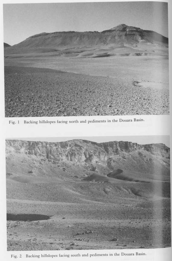 Plate 1.2 |
The northern basin floor north of an east-west branch of Wadi Khawabi El-Kharrar and Wadi Jaria is wider than the southern floor. This asymmetry between north and south was caused by differential insolation of the north- and south-facing slopes (Sakaguchi, 1978b). Mechanical weathering due to daily fluctuation of the ground temperature was more intensive on the south-facing slopes than on the slopes facing north.
The piedmont angles of the pediments are generally not overly sharp but, rather, more gradual. However, sharp piedmont angles can be observed in places (Plate 1.3: 1). A pediment generally has no deposits or is covered by only extremely thin ones. A thin layer or crust (Plate 1.4: 1) of weathered breccia (Plates 1.4: 2, 1.5: 2, 1.6: 1) covers the surfaces of the pediments of the Douara Basin. The debris mantle at the locality shown in Plate 1.5: 1 is relatively thick, though not over 3 m deep, because the locality is near the foot of the south-facing slope.
 Plate 1.3 |
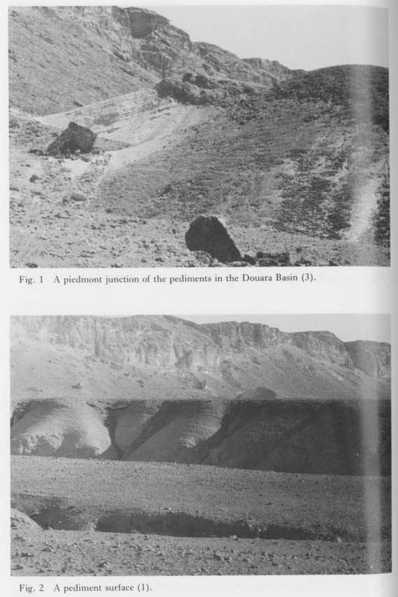 Plate 1.4 |
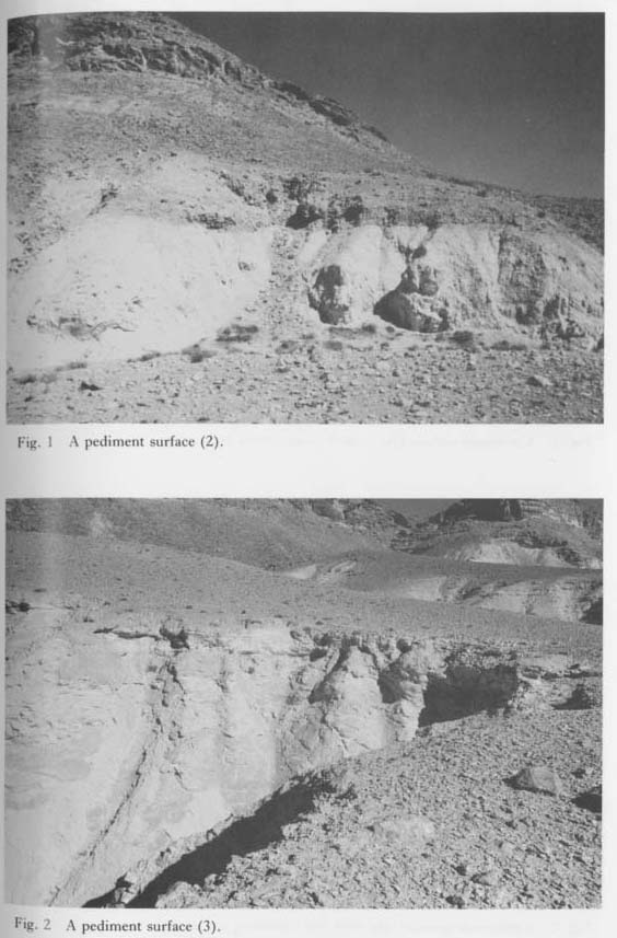 Plate 1.5 |
 Plate 1.6 |
The gradients near the piedmont junctions of the higher pediments are steeper than those of the lower ones. The difference between these gradients becomes unrecognizable a short distance from the head of the higher pediments.
The heads of the lower pediments are directly adjacent to their backing hillslopes, while the higher pediments are separated from the backing hillslopes at the piedmont junctions by a V-shaped valley (Plates 1.2: 2, 1.3: 2, 1.4: 1). According to Twidale (1968), intensive subsurface weathering by ground water takes place under piedmont junctions covered with talus deposits. As a result, pediments become isolated from their backing hillslopes to form a reverse slope at the heads of the pediments. In Plate 1.4: 1, the dip of the reverse slope coincides with that of the marls which make up of the slope. This suggests that V-shaped valleys at piedmont junctions may be formed by weathering, not erosion. However, headward erosion at piedmont junctions should be considered as one of the causes.
Isolated uplands with gently sloping surfaces are scattered in the basin, as shown in Plate 1.6; 2. These uplands are thought to be pediment remnants. Plate 1.7: 1 shows a pediment remnant at Locality 119 near the easternmost part of the basin, These uplands are higher than the higher pediments. Therefore, the Douara Basin has three groups of pediments at different levels. Hereafter we will refer to these pediments as the upper, middle, and lower ones.
All the surfaces of the pediment remnants immediately north of the east-west valley system of Wadi Khawabi El-Kharrar and Wadi Jaria incline gently toward the south. This fact indicates that the valley system has not changed position since the formation of the upper pediments, and the faster northward retreat of the slopes facing south apparently brought about the asymmetrical basin floor. Pediments which have similar morphological features to those in the Douara Basin can be recognized along the foot of Jabal Hayyan and Jabal Antar, west and north of Palmyra respectively (Plates 1.9; 2, 1.10; 1-2; Plates 1.8: 2, 1.9: 1), The pediments around these mountains can also be divided into three surfaces.
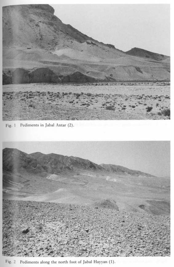 Plate 1.9 |
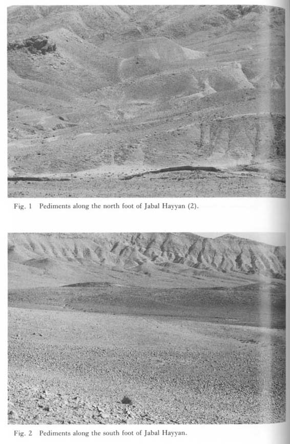 Plate 1.10 |
There are fluvial terraces in the basin (Plate 1.7: 2), but their final correlation has not yet been determined. The author divides them into three surfaces: upper, middle, and lower. The upper and middle terraces are correlated with the middle and lower pediments, respectively. Pediments which are correlated with the lower terraces do not occur. Terraces which are correlated with the upper pediments also do not occur, at least within the basin.
Figure 1.4 shows a schematic topographic profile in the northeastern part of the basin. The lower pediment and its correlating terrace are recognized here. At Locality 67" the pediment surface is covered with a gravel layer 3 m thick. The gravels are angular, subangular, partly well-rounded, and their maximum size reaches 30 cm. Levantine Mousterian blades and other artifacts are included in the deposits. At Locality 67 the gravel size is relatively small, with a 10 cm maximum dimension. The lower pediment at Locality 67' is covered with a gravel layer 2 m thick which includes many artifacts. A handax which was found on the terrace surface at Locality 42 is believed to have fallen from a higher surface. Such translocation of artifacts by natural processes or human activities is common in the basin. The author found an Upper Paleolithic handax on the floor of Wadi Khawabi El-Kharrar at Locality 104 in 1984.

Ages of the pediments and the terraces
Late Acheulean handaxes have been found on the higher terrace at Locality 60, although Late Acheulean artifacts do not usually occur on the middle terraces. On the contrary, Levantine Mousterian artifacts are usually found on the middle terraces. Consequently, we can infer that the higher terraces and their correlative middle pediments were formed in or immediately before the Late Acheulean. On the other hand, the middle terraces and their correlative lower pediments were formed in the Levantine Mousterian.
The lower pediments in the basin are most extensive, with the middle pediments next in area, but the upper pediments are only fragmentarily preserved. The time from the upper pediments' completion until that of the middle ones is estimated to have been much longer than the time from the middle pediments' completion to that of the lower ones.
1.2.2 The pediments along the south foot of Jabal Ad-Dawwara
Pediments fringe the south foot of Jabal Ad-Dawwara (Plates 1.11: 2, 1.12, 1.13: 1; Fig. 1.5). Morphological features of the pediments differ strikingly from those of the pediments in the basin. Apparently only those which are correlated with the lower pediments in the basin occur there. The difference seems to be that the southern flank of Jabal Ad-Dawwara is a dip slope of the limestone strata.
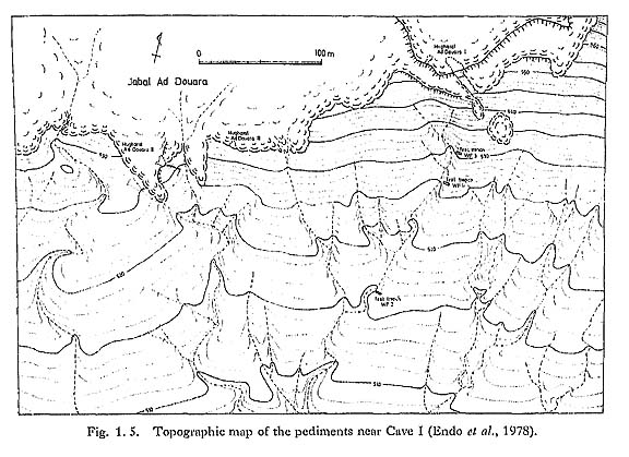
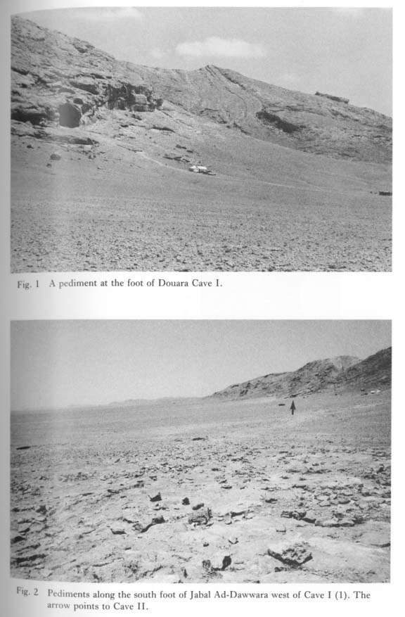 Plate 1.11 |
 Plate 1.12 |
 Plate 1.13 |
The piedmont angles are sometimes sharp (Plate 1.13: 2). The deposits on the pediments do not exceed 2 m in thickness, and there are frequent outcroppings of base rocks (Plates 1.13: 2, 1.14: 1). There are no pediments with the reverse slope. Plate 1.11: 1 shows the pediments at the foot of Douara Cave I. The pediment on which a tent is sitting has a steeper slope behind its head. The top of the slope reaches the front of the cave.
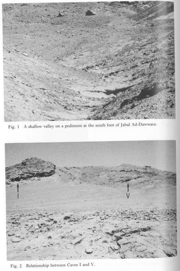 Plate 1.14 |
Near the mouth of Wadi Jaria at Locality 43 three terrace surfaces are developed. The middle terrace is correlated with the adjacent pediment (Fig. 1.6), while there are no pediments which are correlated with the upper terraces in the basin. All terrace surfaces here converge toward the south along the longitudinal profile of Wadi Jaria.

Relationship between pediments and caves
Douara Cave II, which is situated west of Cave I, is formed at the piedmont junction (Plates 1.11: 2, 1.17: 1). It is common for narrow shelves to be attached to the front of the caves in Jabal Ad-Dawwara, as seen at Cave I (Plate 1.15: 1). A similar feature can be recognized at the caves at the Yabrud Site in western Syria (Plate 1.17: 2; Fig. 1.1), where the shelves continue smoothly to the bottom of the adjacent valley.
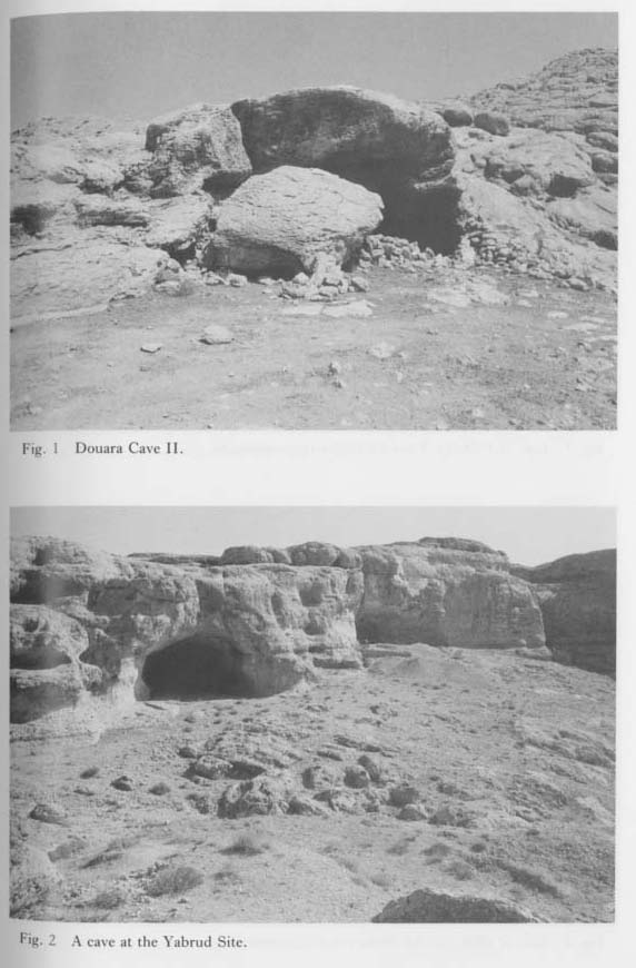 Plate 1.17 |
 Plate 1.15 |
The floor of Douara Cave V, which is situated east of Cave I, lies at approximately the same level as that of Cave I (Plate 1.14: 2). Considering the above-mentioned features, the caves in Jabal Ad-Dawwara seem to have been formed at the heads of pediments, though the causes are not clear. Douara Cave II was formed in relation to the formation of the lower pediments. The pediments which were related to the formation of Caves I and V have disappeared with the retreat of the backing hillslopes, and only the surfaces at the head have been left as narrow shelves at the front of the caves.
The pediments that have disappeared appear to have been middle pediments. Therefore, the formation of Douara Cave I should have finished in or immediately before the Late Acheulean. If this is true, the culture of Douara Cave I could not date from earlier than the Late Acheulean.
Disturbance of the deposits of Douara Cave I
As previously mentioned, Douara Cave I consists of Paleogene limestones. Plate 1.15: 2 shows the south-eastern part of the cave. We can see a row of notches like a chatter mark which runs horizontally through the waist of a sitting man, and coincides with the hori zontally stretched level string in Plate 1.16: 1. These notches were possibly formed by chemical weathering along the contact line of a depositional surface before our first exca vation in 1970. On the other hand, a narrow horizontal zone with a concentration of small pits is 1 m above this notch line. However, this pitted zone slopes toward the entrance of the cave along the western wall, as seen in Plate 1.16: 1. This zone also seems to indicate the position of a former depositional surface. Above this zone, a honey-comb structure can be seen on the wall at the entrance of the cave (Plate 1.16: 2), a usuall consequence of subaerial weathering. Therefore, the cave detritus probably was not deposited above the pitted zone.
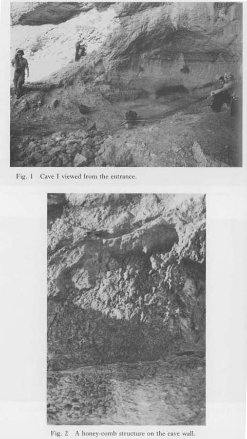 Plate 1.16 |
The surficial cave deposits consist only of artifacts that belong to the Epi-Paleolithic and the Neolithic (Endo et al., 1978). The Epi-Paleolithic artifacts in particular are found only in Horizon II, which is locally distributed near the entrance of the cave. The geological profile at X=8 in 1974 (Fig. 1.7) shows that the uppermost part of the cave deposits was horizontally removed after the deposition of Horizon II. On the other hand, many Pre-Pottery Neolithic (PPN) artifacts have been found on the surface of the slope or in the talus deposits in front of Cave I.
 Fig.1.7 |
Therefore, one can infer that the uppermost cave deposits (about 1 m thick) were thrown out the slope in front of the cave, probably by human activities, However, the time and intent of the actions are not clear.
1.3 THE PLUVIAL LA K ES
1.3.1 Lake of 1974
The hypothesis that lakes occupied the Palmyra Basin in the past was suggested by the formation of the Lake of 1974 (Plate 1.18: 1-2). The water level of the Lake of 1974 had dropped by the end of August 1974, when our mission reached Palmyra, but the maximum shoreline was indicated by linear accumulation (thatch zone) of plant remains and feces of camels and sheep. The elevation of the shoreline was determined to be 377 m above sea level by referring to a bench mark south of Palmyra. After that, elevations of the geomorphic surfaces in the Palmyra Basin were determined based on this. elevation value.
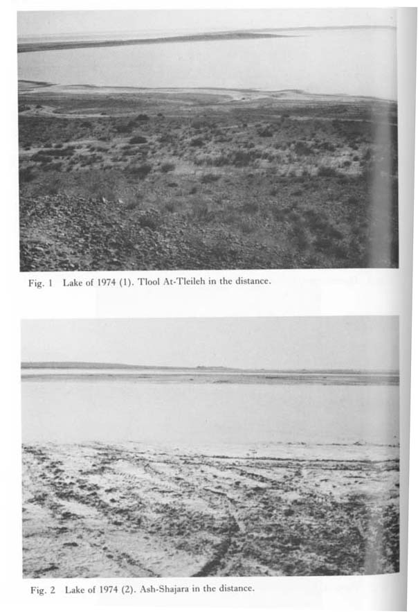 Plate 1.18 |
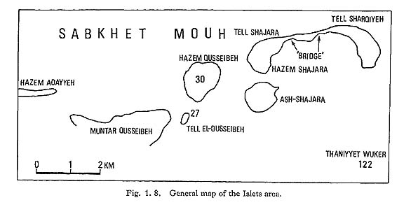
Isolated or peninsula-like uplands are distributed in the southern part of Sabkhet Mouh. We called this the "Islets area" (Fig. 1.8). In 1974 this area was intensively investigated to obtain lacustrine evidence.
Along the inner side of the thatch zones, wave-built terraces consisting of coarse sand and gravels 7-8 cm in diameter were formed step by step as the water level dropped (Plate 1.19: 1).
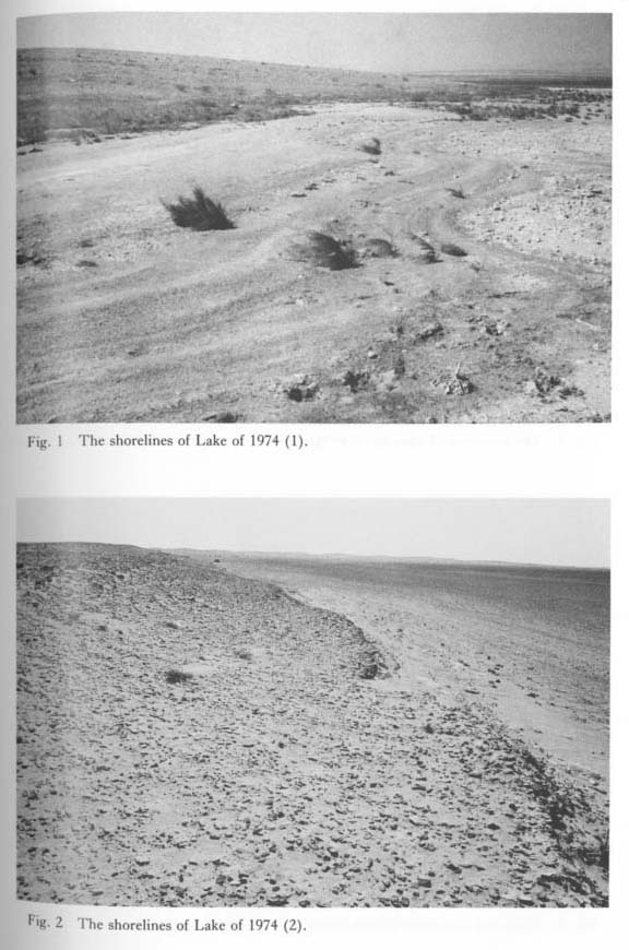 Plate 1.19 |
The local people reported that no lakes have appeared since 1974 in the Palmyra Basin. In 1984 Sabkhet Mouh was covered by a salt crust with a polygonal pattern (Plate 1.26: 1).
Salt concentration in the groundwater in Sabkhet Mouh is high. The groundwater level was -70 cm at Bl in the central part of Sabkhet Mouh and -30 cm at a salt-field south of the Islets area. The maximum shore line of the Lake of 1974 was still recognizable in 1984 (Plates 1.19: 2, 1.20: 1).
 Plate 1.20 |
It is interesting to note that Tamarix grows along the maximum shoreline of the Lake of 1974 around Hazem Shajara, Tell Shajara, and Tell Shargiyeh, in the eastern Islets area (Plates 1.20: 1-2, 1.21: 1-2). According to Assad (1982), "the occurrence of this tree indicates nearby water, and sometimes it even grows in saline soils. It requires a great deal of water during the first two years of the plantation and the roots go down as deep as 10 meters". Thus, the stagnate water in 1974 was presumably favourable to the growth of Tamarix. Four Tamarix trees in this area can be dated by their tree-rings to an age of 3+~8 years.
 Plate 1.21 |
1. 3. 2 Lacustrine terraces
Lacustrine terraces can be clearly recognized in the north, west, and south sides of Sabkhet Mouh (Plates 1.20: 2, 1.22: 1-2, 1.23: 1-2). Plate 1.22: 1 shows an isolated upland, called Tell El-Qusseibeh. The upland is divided into two terraces, a higher (389.5 m above sea level) and a lower one (383 m) (Sakaguchi, 1978a). A desert pavement of angular-subangular flint gravel and well-rounded to flat limestone gravel covers the upper terrace surface. The gravel size reaches a maximum of 10 cm. Under the desert pavement at Locality 27 there are terrace deposits, 265 cm thick, consisting of gypseous silt and sand in the upper half and angular-subangular gravels with a gypseous matrix in the lower half. The lower terrace deposits are 400 cm thick and consist of gypseous silt and gravels. The maximum diameter of the gravels is 10 cm.
 Plate 1.22 |
 Plate 1.23 |
Plate 1.22: 2 shows Hazem Quesseibeh north of Tell El-Qusseibeh. This upland is also divided into two terraces, an upper (387 m above sea level) and a lower one (383 m) (Sakaguchi, 1978a). A desert pavement, which includes gravels 25 cm in maximum size has developed on the upper terrace surface. Salt appears under this pavement (Plate 1.24: 1).
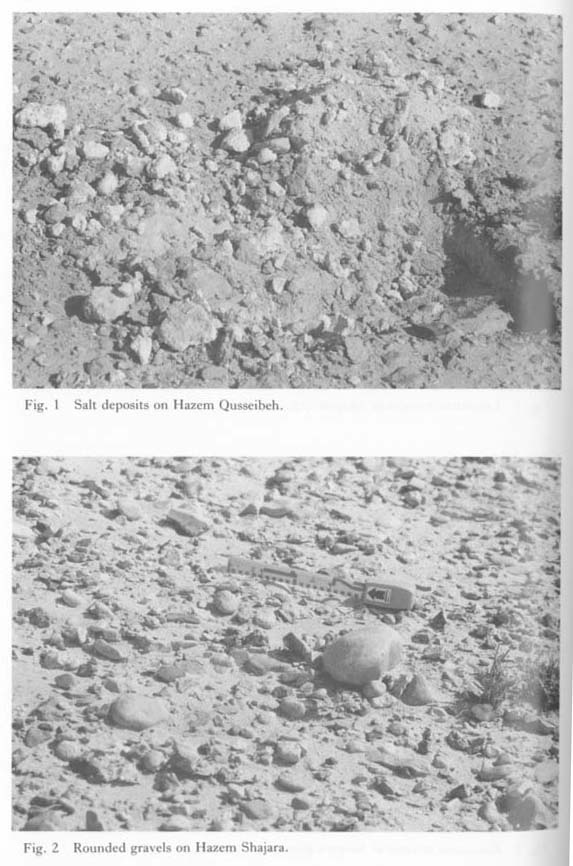 Plate 1.24 |
Plate 1.20: 2 shows two terraces of Hazem Shajara northeast of Ash-Shajara. A few rounded gravels with a maximum of 10 cm are scattered on the upper terrace surface (Plate 1.24: 2).
The rounded allochthonous gravels on the terrace surfaces in these isolated uplands were surely carried from the southern drainage basin of Sabkhet Mouh. This evidence proves that the isolated uplands were separated from the southern drainage basin of Sabkhet Mouh by erosion.
Plate 1.21: 2 shows the upper terrace of Hazem Shajara in 1984, as viewed from Tell Shajara. The slope is partially covered with eolian sand, which was less apparent in 1974.
A lacustrine terrace can also be recognized in Tlool At-Tleileh (Plate 1.29: 1-2). The superficial deposits include many rounded gravels (Plate 1.30: 1). Calcretes are formed beneath the desert pavement (Plate 1.30: 2), The geomorphological discontinuity at 387 m, which the author pointed out in the previous report (Sakaguchi, 1978a), can also be recognized here.
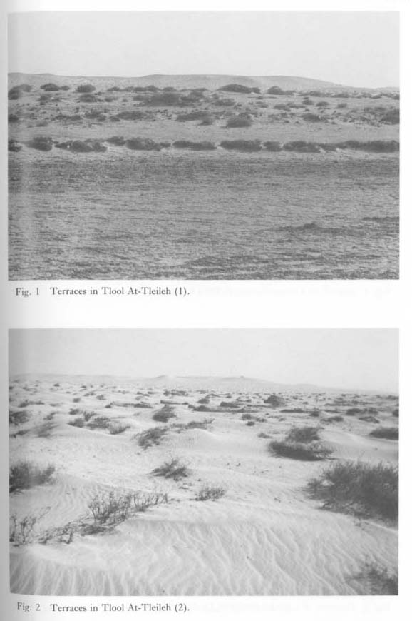 Plate 1.29 |
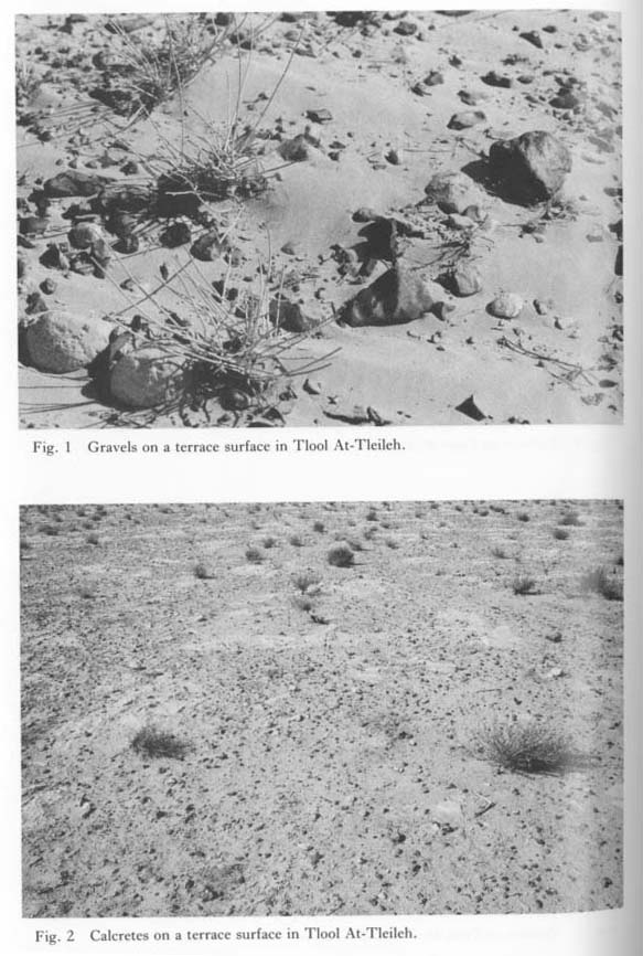 Plate 1.30 |
Plate 1.33: 1 shows an outcropping of lacustrine deposits along Wadi Ai'd which runs beside the Sanctuary of Bel (Localities 57 and 57b in 1974; Sakaguchi, 1978a). The light brown gray hard clayey silt, which includes plant casts, is covered with a gravel layer about 1 m thick (Plate 1.33: 2). The three blackish-gray organic bands in the deposits have 14C dates of 18,900±200 BP (TK-150) and 19,410±150 BP (GrN-7597). The elevation of the top of the lacustrine deposits at Locality 57b was 397 m. This was the highest water level at stage A of the Palmyra Pluvial Lake.
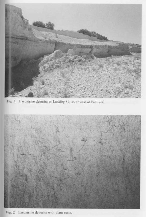 Plate 1.33 |
1. 3. 3 Birdfoot deltas
Ancient natural levees which belong to the birdfoot deltas of Wadi Abou Obeid or Wadi Ai'd can be recognized between Localities 47 and 50 west of Palmyra, Localities 55 and 56 south of Locality 47 (Plate 1.32: 2). Their surfaces lie 380-390 m above sea level. In the previous report the author concluded that the formation of the deltas ended imme diately after the Middle Paleolithic due to the disappearance of the lake.
The same topography can also be recognized at Localities 108, 109, and 110 along the pipeline east of Tlool At-Tleileh (Plate 1.31: 1-2). The author will call these uplands "tongue-like uplands" in this report. Their height is about 4 m, and their longitudinal axes converge on Wadi Qusseibeh which runs north to south through the eastern margin of the Douara Basin to reach the eastern end of Sabkhet Mouh. These tongue-like uplands are surely the remnants of a birdfoot delta whose elevation at the southern end is 398 m above sea level. This value is nearly the same as the maximum water level of the stage A Pluvial Lake.
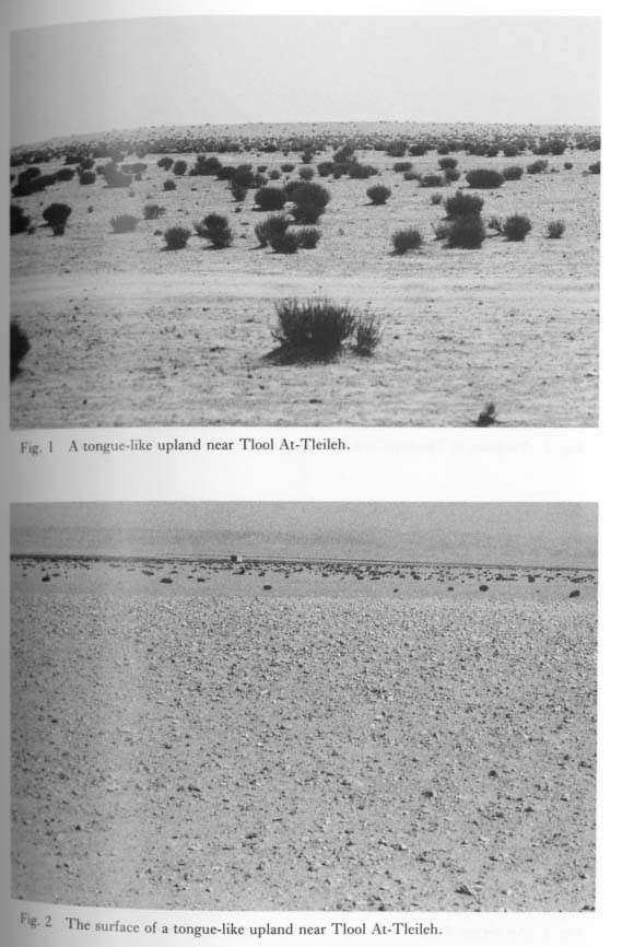 Plate 1.31 |
1. 3. 4 Lacustrine terraces in Thaniyyet Wuker
An isolated upland 3 km southeast of Ash-Shajara consisting of horizontally bedded sand is divided into two terraces, whose relative heights are greater than 4 m and 8 m, respectively (Plate 1.27: 1-2). These terraces are surely lacustrine. The lower terrace is dissected to become yardangs on the north side. The upper terrace is covered with a dissected sand dune elongating east to west, and with nebkahs less than 1 m high. The southern part of the lower terrace is dissected to become partly isolated uplands 1.5-2 m in relative height. These uplands consist of light grayish brown gypseous clay or silt and have a sort crust 20 cm thick on their surface (Plate 1.28: 1-2). These isolated uplands look like a mesa (Plate 1.28: 1). Pre-Pottery Neolithic B (PPNB) artifacts are scattered at Locality 122 on the lower terrace. The elevation of the terraces is greater than 385 m and 381 m, respectively.
 Plate 1.27 |
 Plate 1.28 |
There are many yardangs in Tlool At-Tleileh (Plate 1.32: 1). These yardangs consist of fine sand with horizontal or cross bedding. Their sedimentary features show that the fine sand was lacustrine. The top of the yardangs is 382 m above sea level. The original topography of the yardangs is correlated with the lower terrace in Thaniyyet Wuker.
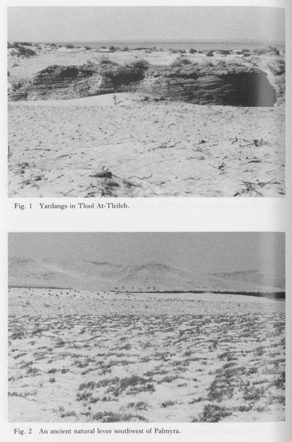 Plate 1.32 |
As previously mentioned, there are terraces in the Islets area with elevations of 382 or 383 m and breaks in the upland slopes at the same elevation (Tell El-Qusseibeh, 383 m; Hazem Qusseibeh, 383 m; Hazem Shajara, 382 m; Tell Sharqiyeh, 383 m). These are also correlated with the lower terrace in Thaniyyet Wuker.
Consequently, a lake surely existed in the Palmyra Basin in or slightly before the Pre-Pottery Neolithic B (7000-6000 BC). In the previous report, the author suggested the existence of a pluvial lake during the period 13,000-7,000 BP. The lacustrine terraces in Thaniyyet Wuker and their correlative landforms confirm the author's hypothesis. Site 122 of the PPNB was probably occupied immediately after the water level began to drop. Hereafter, this lake will be called Palmyra Pluvial Lake B (Lake B). The stage A lake Palmyra pluvial Lake A (Lake A).
There are two narrow low uplands connecting Tell Shajara and Tell Sharqiyeh. These are called "bridges 1 and 2" (Plate 1.21: 1). These bridges consist of Neogene deposits and were probably formed by wave action during the lake periods.
1. 3. 5 Results of a drilling in Sabkhet Mouh
Our mission conducted a geological survey by drilling to obtain lacustrine evidence at Bl, the center of Sabkhet Mouh, employing a well digger in Palmyra who used the percussive drilling method (Plate 1.25: 1). Samples were collected from the material that adhered to the six channels of the 2 m long drilling bit (Plate 1.25: 2). Contamination of the samples during the operation could not be avoided. The drilling was stopped at a depth of 34 m, when the drill hit gushing groundwater.
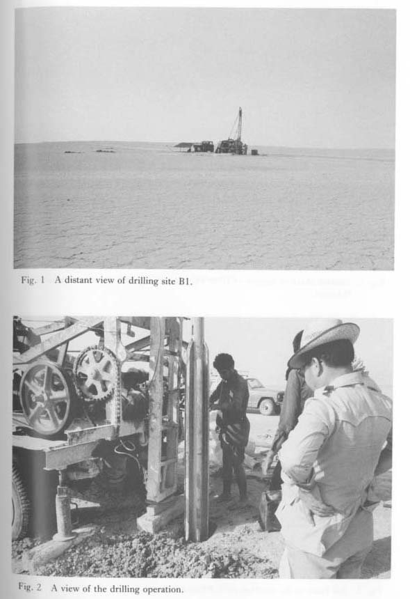 Plate 1.25 |
The stratigraphy of the deposits is as follows (color in dry condition):
| 0 - 1.0 m | light grayish brown clay with sand and gypsum crystals, |
| 1.0- 1.5 | brown clay with gypsum crystals, |
| 1.5- 3.0 | light grayish brown clay with sand and gypsum crystals, |
| 3.0- 4.0 | no sample, |
| 4.0- 5.0 | light gray clay with gypsum crystals, |
| 5.0- 6.5 | gray clay with gypsum crystals, |
| 6.5- 7.5 | light gray clay with gypsum crystals, |
| 7.5- 9.0 | light yellowish gray clay with sand gypsum crystals, |
| 9.0-10.5 | light yellowish gray clay with gypsum crystals, |
| 10.5-13.0 | light brownish gray clay with gypsum crystals, |
| 13.0-14.0 | light yellowish gray clay with gypsum crystals, |
| 14.0-16.0 | light gray clay with gypsum crystals, |
| 16.0-17.0 | light gray clay, |
| 17.0-18.0 | light brownish gray clay, |
| 18.0-19.0 | brown clay, |
| 19.0-20.0 | light brownish gray clay with sand, |
| 20.0-21.0 | brown clay, |
| 21.0-22.0 | light brownish gray clay, |
| 22.0-23.0 | light brownish gray clay with sand, |
| 23.0-24.0 | light yellowish gray clay, |
| 24.0-25.0 | light yellowish gray clay with sand, |
| 25.0-26.0 | gray clay, |
| 26.0-26.5 | light gray clay with gypsum crystals, |
| 26.5-27.0 | gray clay with gypsum crystals, |
| 27.0-28.0 | light gray with gypsum crystals, |
| 28.0-30.0 | light brownish gray clay, |
| 30.0-32.0 | light brownish gray clay with gypsum crystals, |
| 32.0-33.0 | light brownish gray clay with sand and granules, |
| 33.0-34.0 | light gray clay, sand, and angular flint gravels (maximum diameter; 2 cm). |
The deposits are undoubtedly lacustrine. The samples from the following depths are brownish in color: 0-3.0 (or 4.0?), 10.5-13.0, 17.0-23.0, and 28.0-33.0m. These strata are called brown zones I, II, III, and IV, respectively. These zones and the adjacent yellowish portions contain sand particles, with the exception of the deepest portion sampled at depth 33.0-34.0 m. According to the mineralogical investigations, the mineral constituents change gradually from the bottom to the top of the deposits as follows: calcite →dolomite→gypsum. Therefore, the salinity of the lake water increased gradually toward the top of the deposits. Halite occurs in all samples: probably the halite which is contained in the uppermost deposits dissolved in the groundwater and mixed with the non-saline sediment materials during the drilling. Judging from the mineral constituents, the lake was initially fresh.
Calcite is present in the samples from below 11.0 m and above 5.0 m but is absent between 5.0 and 11.0 m. The calcite from the deposits above 5.0 m suggests that large quantities of fresh water flowed into the basin floor from the drainage area during the last stage of the deposition.
The browning of brown zone I is inferred to have been brought about by aeration caused by the lowering of the groundwater. The sand particles are probably eolian. During the period of brown zone I a playa lake was sometimes formed. This period is called the Playa Lake stage. The other brown zones are considered to have formed in the same manner. Therefore, Pluvial Lake A seems to have dried up temporarily three times. However, this inference contradicts the results of the mineralogical investigations. The mineralogical findings indicated that the salinity increased gradually toward the top of the deposits, rather than changing cyclically. We must leave the resolution of this anomaly for future study.
In the previous report the author inferred that Lake A surely existed in 38,500 BP, and it might have originated before 45,000 BP (Sakaguchi, 1978a). No dating has been carried out on the Bl samples because of the absence of suitable materials. In this paper the author attempts to estimate the age of Lake A based on sedimentation rates of lacustrine deposits in arid regions of the world. The data used are as follows:
- Thar dunefield;
- 450 cm/12,800 y=0.35 mm/y (Wasson et al., 1983 and 1984),
- Lake Bogoria, Kenya;
- 145 cm/14,800 y=0.98 mm/y, 18.5 m/12,100 y=1.53 mm/y, 16.0 m/28,000 y=0.57 mm/y (Tiercelin et al., 1981),
- Lake Naivasha;
- 2.56, 16.25, 2.25, 3.76 mm/y (Richardson et al., 1972),
- Lake Abhé, Ethiopia;
- 10 m/16,100y= 0.62 mm/y, 19 m/25,100 y= 0.76 mm/y (Gasse et al., 1978),
- Birket Ram Lake, Golan Heights;
- 24.5 m/29,300 y=0.8 mm/y (Singer et al., 1978),
- Salt Lake deposits in Rajasthan;
- 3.25 m/9,250 y=0.35 mm/y, 2.30 m/9,260 y=0.25 mm/y, 1.25 m/2,970y= 0.42 mm/y (Singh et al., 1972),
- Lake Chad;
- 7m/8,750y=0.80mm/y (Servant-Vildany, 1979),
- Ancient Lake Cahuilla, California;
- 3.0-5.0 mm/y (Waters, 1983),
- Searles Lake, California;
- 37.1 m/33,000 y=1.12 mm/y, 37.5 m/30,100 y=1.25 mm/y (Peng et al., 1978).
The sedimentation rate of Lake A is inferred to have been low, because the areal ratio between the water surface and the catchment basin is estimated to be 10: 1. In this paper the smaller values are adopted, such as 0,25-0.50 mm/y among the above-mentioned estimates.
In the previous report the author concluded that Lake A diminished due to a lowering of the water level after 18,000 BP and completely disappeared around 15,000 BP. Brown zone I, 3 m thick, formed after 15,000 BP. If the other deposits, 31 m thick, accumulated at the above-mentioned rate, the age of the portion not including brown zone I is 124,000- 62,000 y. Therefore, the age of the whole 34 m deep deposits is 139,000-77,000 y. The formation of Lake A possibly began in the initial stage of the Last Glacial or during the Last Interglacial. If a constant rate of accumulation of 0.5 mm/y is used to estimate the age of each brown zone except zone I, the results are as follows: II, 30,000-35,000 BP; III, 43,000-55,000 BP; IV, 65,000-75,000 BP.
1.4 CLIMATIC CHANGES SINCE AD 273
1.4.1 Accumulation of debris and wind erosion in the Palmyra ruin
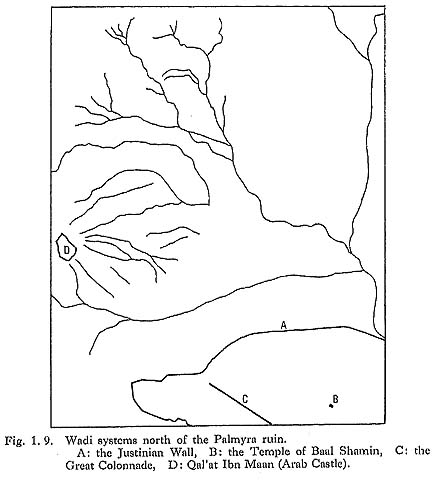
The Roman army destroyed the ancient city of Palmyra in AD 273 and left it to fall to ruin. The Palmyra ruins are difficult to protect from flooding because they are surrounded by Wadi Abou Obeid on the north and Wadi A'id on the south (Figs. 1.9, 1.10).

On May 12, 1982, a rain cloud, which originated above mountains far to the west, caused a tremendous flood in Wadi A'id at about 4-5 p.m. The torrent was 200 m wide and 3-5 m deep, and it continued for 20 hours to cover the Agora and the Temple of Nabo beside the Wadi floor. The Palmyra ruin had not experienced such a flood for at least a century (Assad's pers. comm.).
Such a flood was probably rare during the period when Palmyra was prosperous. However, after the Roman destruction the ruins were vulnerable to flooding, and as a result, the ruin had been covered with debris to a depth of more than 1 m (Plates 1.42: 2, 1.43: 1-2). Recently, houses dating from no earlier than the Byzantine period have been excavated on the Great Colonnade north of the Tetrapylon (Plate 1.43: 1), indicating that the Great Colonnade was buried during or after the Byzantine period.
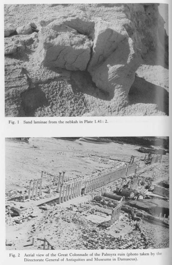 Plate 1.42 |
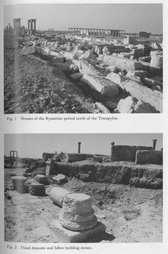 Plate 1.43 |
The ancient city of Palmyra was enclosed by a wall 12 km long. After the wall was de stroyed in AD 272, it was restored by the Byzantine Emperor Justinian (526-565). However, it was again destroyed by Marwan II (744-750), the last Ummayyad Caliph. Many fragments of the stone buildings lie on the flood deposits (Plate 1.43: 2). An earthquake which occurred in the early 10th century knocked over many building stones (Ass'ad and Taha, 1966). Floods that brought the accumulating debris probably occurred between the 8th and the 10th century. Therefore, if the climate was calm in the period when Palmyra was prosperous, it has changed to one of periodic floods since the Byzantine period.
Almost all the columns of the Great Colonnade have a 0.5-1.0 m wide wind abrasion zone 1 m above the ground (Plate 1.44: 2). However, the columns near the Agora have no such zone (Plate 1.44: 1). This difference probably is related to the age of accumulated debris. The accumulation of the debris near the Agora probably took place in the recent past.
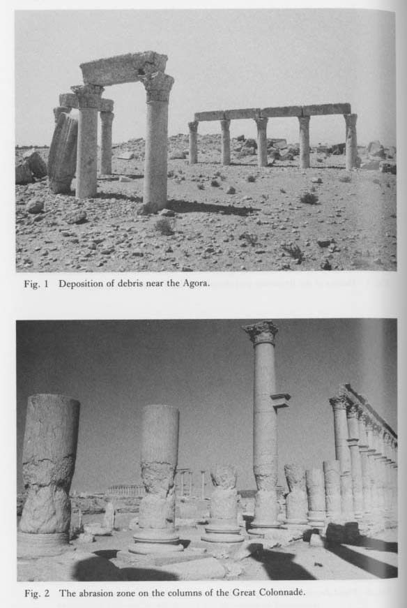 Plate 1.44 |
The buildings of the Palmyra ruin were made from limestone which was carried from a quarry 12 km northeast of the ruin. Defacement of the uppermost part of the buildings was caused by corrosion from atmospheric water, not by wind abrasion (Plates 1.45: 1, 1.46: 1). This reveals the honey-comb structure of the limestone as can be seen at the base of one of the Tetrapylons (Plate 1.46: 2).
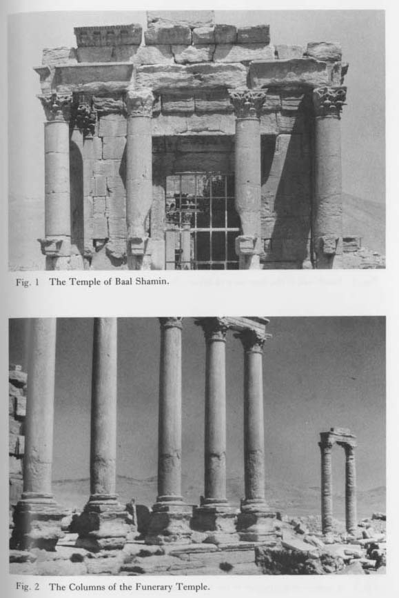 Plate 1.45 |
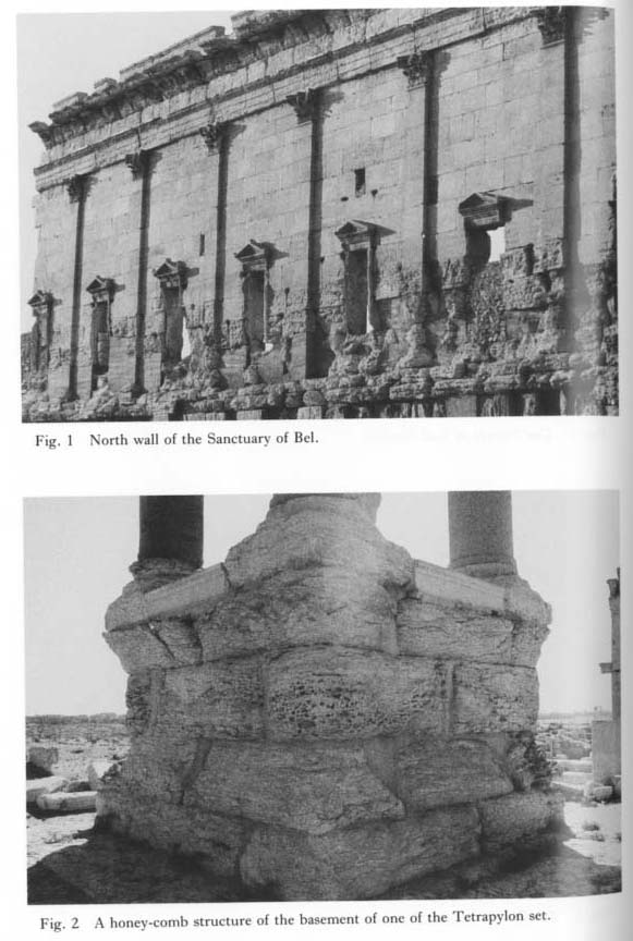 Plate 1.46 |
The dominant wind direction at the time of the corrosion was probably from the northwest as it is today. The foot of the north wall of the Sanctuary of Bel has been abraded most strongly in the western corner (Plate 1.46: 1). This abrasion is in line with the present dominant wind direction. However, the abrasion on the Temple of Baal Shamin and on six columns of the portico of the Funerary Temple indicates a dominant wind direction from the north (Plate 1.45: 1-2). But the angle of the upper fringe of the abrasion zone in the Funerary Temple is too steep to have been brought about by wind erosion. According to Garstang's photos taken in 1920 before the excavation, both temples were horizontally buried (Browning, 1979). Therefore, the steep declination shown in the Funerary Temple cannot be explained by a past declined ground surface. The dominant wind direction in the ruin may have been extremely local.
1.4.2 Eolian sand
Nebkahs in various stages of development can be recognized around Sabkhet Mouh. Nebkahs are shadow dunes whose sand is deposited in the lee side of equidimensional dense grasses or shrubs (Hesp, 1981; Ash and Wasson, 1983). The author made a serious mistake in describing the relationship between wind direction and dune sand accumulation in the previous report (Sakaguchi, 1978a). The spellings "nebka" and "nebkha" are widely used, but in this paper the author uses "nebkah", as suggested by Abdul Salam of Damascus University.
The plan and longitudinal profile of nebkahs generally depend on the width and height of the grasses or shrubs, wind velocity, and sand mass transported. The plan shows have various shapes: oblong, elliptical, lanceolate-oblong, ovate, oval, or lanceolate. The small nebkahs less than 1 m high in the fringe of Sabkhet Mouh are mostly lanceolate or lanceo- late-oblong in shape (Plates 1.35: 2, 1.36: 1, 1.37: 1-2). Their longitudinal profile is steep and convex on the windward side, but slightly concave, or linear, or slightly convex on the lee side (Plates 1.36: 1-2, 1.37: 1-2). On the other hand, the large nebkahs from 2 m to 6 m high are oblong, elliptical, ovate, or oval in shape, and are convex and steep on both the windward and lee sides (Plates 1.38: 1-2, 1.39: 1). The margin of the small nebkahs merges into the adjacent sandfield, but that of the large nebkahs is discordant. Most of the small nebkahs east of Tlool At-Tleileh have ripple marks on their surfaces (Plate 1.37: 1). The direction of the long axis of all the nebkahs in the fringe of Sabkhet Mouh is N60-80°W, independent of size. This direction is the same as the present dominant wind direction.
 Plate 1.35 |
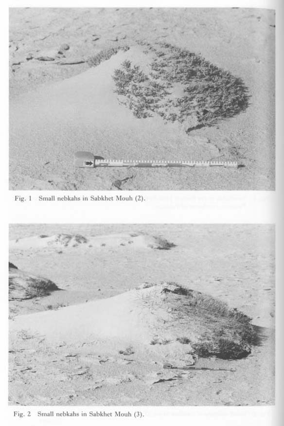 Plate 1.36 |
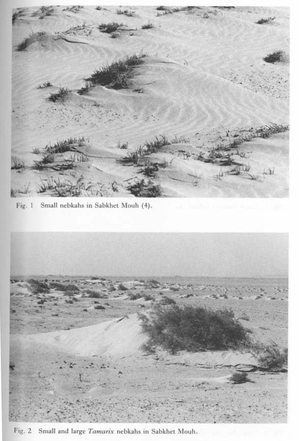 Plate 1.37 |
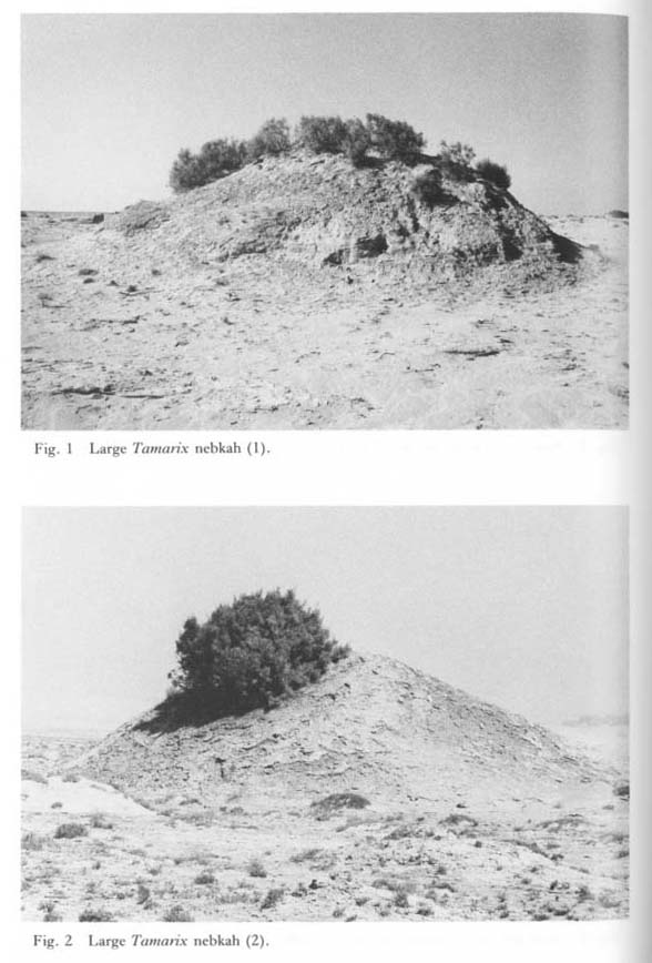 Plate 1.38 |
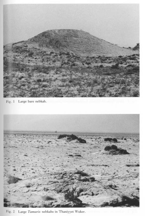 Plate 1.39 |
The size of the nebkahs generally increases with distance from the fringe of Sabkhet Mouh. The large nebkahs are mainly distributed north of Muntar Qusseibeh (Plate 1.40: 1) and in Thaniyyet Wuker (Plates 1.38: 1-2, 1.39: 1-2). The large nebkahs, whose maximum relative heights reach 5.5 m, are most commonly distributed along the fringe of Sabkhet Mouh. The large nebkahs in Thaniyyet Wuker are scattered among the mesa like uplands outside the small nebkah zone along the fringe of Sabkhet Mouh. The large nebkahs here are 3-4.7 m high, 12-28 m long, and 7-14 m wide.
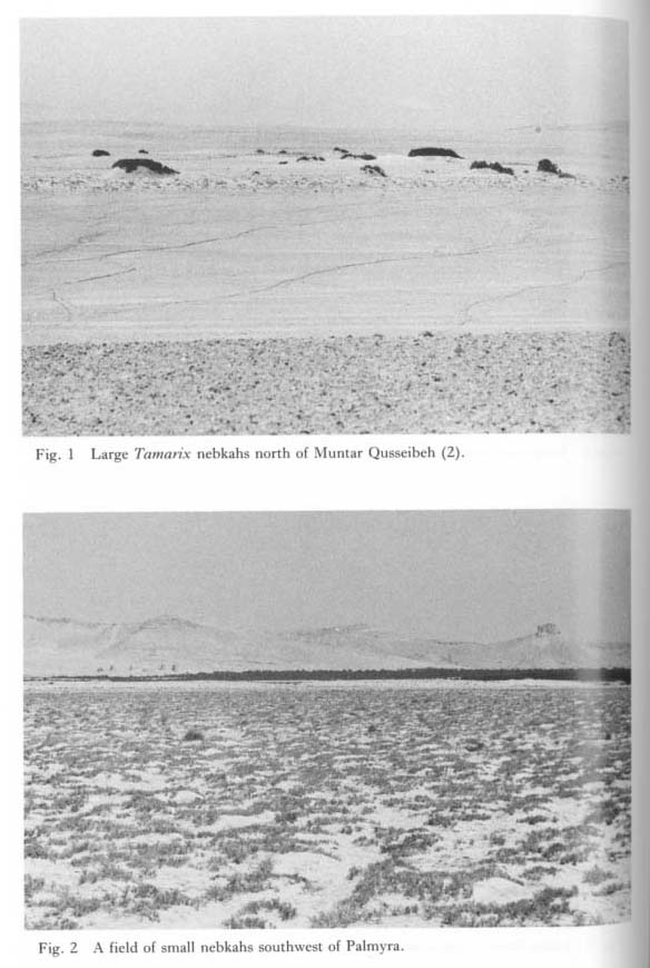 Plate 1.40 |
Halocnemum strobilaceum and Tamarix nebkahs are dominant in the Palmyra Basin, The former are small, but the latter reach 5-6 m (Plates 1.38: 2, 1.39: 2, 1.40: 1). Some of the mature nebkahs with Tamarix shrubs on the top begin to affect erosion on the flank (Plate 1.38: 1). Tamarix roots can reach 10 m under ground (Assad, 1982). Any Tamarix on top of a 5 m nebkah is considered to be at a critical stage in its growth, and probably will be killed by a slight lowering of the groundwater level. Historically, Tamarix shrubs have been used for fuel or building material by Palmyrian and Bedouin peoples and, large nebkahs may be rendered barren by such human activities. The density of the nebkahs depends on the initial vegetation cover. Small nebkahs, clustered like a huge flock of sheep, occur on the north fringe of Sabkhet Mouh (Plate 1.40; 2).
Large bare nebkahs are finally flattened by wind and water erosion. There are two large, isolated, abraded nebkahs east of Ash-Shajara (Plate 1.41: 1-2). One of which is 3 m high. Its width and length are 10 and 20 m, respectively (Plate 1.41: 2). The width of this nebkah is longer than its length, that is, the reverse of the usual situation for the normal nebkahs. The sand layer which forms the nebkah has laminae about 2 mm. The strike and dip of the laminae are N40°E and 14°E, respectively (Plates 1.41: 1-2, 1.42: 1). The dominant wind direction determined from these data is similar to the present one.
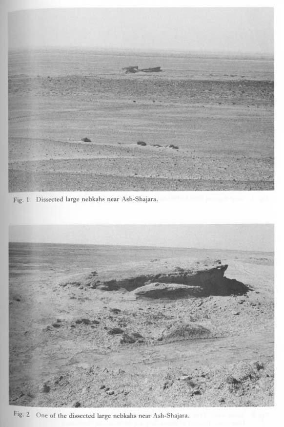 Plate 1.41 |
Nebkahs along the shoreline of the Lake of 1974 grow 1 m in 10 years. If this growth rate is applicable to the large nebkahs, fifty years would be necessary for the growth of a large nebkah 5 m high. This time duration is in accord with the observation of a staff member of the Palmyra Museum that large nebkahs did not exist several decades ago in the Islets area.
Therefore, one can infer that the climate around fifty years ago was probably somewhat different from today, and that the groundwater level of Sabkhet Mouh was higher than it is today. However, the author has not yet obtained lacustrine evidence from that time.
In the previous paper the author concluded that there was a successional relationship between the small and large nebkahs. But this conclusion may not be correct. Several large Tamarix nebkahs are scattered among a dense zone of low Halocomneum nebkahs on the fringe of Sabkhet Mouh. The heights of the two groups of nebkahs are discon tinuous. This shows that the two types are independent.
Eolian sand covers the north flank of Jabal El-Qayed west of the Palmyra ruin (Plates 1.34: 2, 1.35: 1). The coverage seems more widespread than in 1974. Nebkahs which are distributed in the upper part of the Valley of Tombs did not exist in 1974. These indicate that desertification has steadily progressed in the last ten years.
 Plate 1.34 |
1.5 DISCUSSION AND CONCLUSIONS
1.5.1 Paleoenvironments viewed from the pediments
There are many theories concerning the definition, morphology, and genesis of pediments. Unfortunately, these theories also include many contradictions. The author supports Birot's view (1968) that pediments are a typical arid climate landform in a broad sense, and uses this landform as an indicator of paleoclimates in this paper.
Figure 1.11 shows a schematic profile which indicates the relationship among the geomorphic surfaces in Jabal Ad-Dawwara. The upper and middle terraces in the Douara Basin are considered to be mantled pediments correlated with the middle and lower pedi ments, respectively.
As previously mentioned, primary Late Acheulean artifacts are found only on the upper terraces, while primary Levantine Mousterian artifacts are found only on the middle and upper terraces. Therefore, it is concluded that the middle pediments were formed in or before the Late Acheulean, and the lower pediments, from the Late Acheulean to the Levantine Mousterian.
The time necessary to complete the lower pediments is equivalent to that necessary to retreat from the position of the final backing hillslopes of the middle pediments to the present backing hillslopes of the lower pediments. The distance between the two backing hillslopes is estimated to be about 100 m. The retreat rates of free faces are estimated as 1-2 mm/y in Natal Drakensberg (King, 1953) and 2-4 mm/y in the Atacama Desert (Akagi, 1973). Based on these values, the rate of 2 mm/y is adopted in this paper. At that rate, 50,000 years are necessary to complete the above-mentioned retreat. On the other hand, the time interval between both ages of the upper and middle pediments is estimated to have been rather long. A remnant of the upper pediments is located about 2 km south of the present backing hillslopes. If the final backing hillslopes of the upper pediments were located 1 km south of the present backing hillslopes, at the midpoint between the two slopes, the above-mentioned time interval could be estimated at about 500,000 years. A barite nodule which was found in the hearth deposit of the Douara Cave I has been dated 75,000 BP by the fission-track method (Akazawa, 1979). If the Levantine Mousterian terminated 75,000 years ago, the period of the middle and upper pediments is calculated to have ended about 130,000 BP (50,000 y+75,000 y) and about 630,000 BP (125,000 y+ 500,000 y), respectively.
Therefore, based on geomorphological evidence, the climate of the Palmyra district has been arid in a broad sense since 600,000 BP. More strictly speaking, the climate of the Palmyra district fluctuated between semi-arid and semi-humid.
The caves on the southern flank of Jabal Ad-Dawwara were formed at the head of the pediments. The pediment related to Douara Cave II is correlated with the lower pediments in the Douara Basin. The vanished pediments related to Douara Caves I and V are correlated with the middle pediments in the Douara Basin. This correlation does not contradict the fact that the oldest artifacts of Douara Cave I are from the Yabrudian, the final stage of the Late Acheulean.
The age of Pluvial Lake A is estimated as 77,000 BP to 139,000 BP. On the other hand, the interval between Levantine Mousterian and Yabrudian is estimated to be 50,000 years in the Douara Basin. If so, the Yabrudian goes back to 130,000 BP. This date is approx imately the same as the larger age estimate for Lake A.
Age data for about 660 speleothems and about 140 spring-desposited travertines were collected from former glacial and periglacial areas, as well from as areas of warmer climate similar to that in Mexico, Jamaica, and the Mediterranean. Speleothem growth was most plentiful between approximately 130,000 and 90,000 BP and from about 15,000 BP to the present day. Since speleothems grow mainly in warm and humid climates (Henning et al., 1983) the climate in the Yabrudian was probably warmer and wetter than it is today and it is possible that Lake A was formed at that time.
1.5.2 Climatic changes viewed though the lacustrine evidence (Fig. 1.12)

The existence of a long-lived lake indicates that precipitation in the Palmyra Basin must have been greater than it is today, under a climate as warm as today's. If the climate were cooler than today's, greater precipitation would not always be a necessary condition.
There were glaciers in the Lebanon Mountains, at least during the Last Glacial, and the temperature was about 6°C lower (Messerli, 1966). Therefore, the climate in the late Quaternary was also undoubtedly cooler in the Palmyra district. Today the precipitation in the Palmyra district is a function of the polar front in winter. The general atmospheric circulation pattern shifted to the south during the glacial ages, and the Palmyra district probably had much more precipitation than today due to the activity of the polar front in summer.
According to micromorphological studies of Hayonim Cave, Israel, calcite cementation found in the center of the cave corresponds to the Mousterian period, and that near the cave entrance is from the Kebaran period. This suggests moister environments during these periods (Goldberg, 1979). According to Leroi-Gourhan's palynological investigations (1980), the cold-wet maximum seems to have been around 45,000 BP in the Middle East.
The precipitation of the rainy season of 1973/74 at Palmyra, which brought about the long stagnation of water in the basin, exceeded the annual mean value by only 150 mm. In arid regions even slight increases of the annual precipitation may cause severe environ mental changes.
The vegetation in the Palmyra district during the Lake A period must have been luxuriant due to the summer rain. Enormous numbers of seeds and other plant remains which were found in the hearth deposits of Douara Cave I in 1984 strongly support this mference.
The wetter climate of the Lake A period ended around 19,000-18,000 BP. After that, the climate suddenly became dryer, and Lake A dried up to leave the lacustrine terraces around Sabkhet Mouh. The diminishing lake temporarily stagnated at 387 m above sea level. The lake water was fresh initially, but became saline around 18,000 BP, judging from the salt deposits of the upper lacustrine terraces. The salt deposits on the terraces are not as remarkable in the northern part of Sabkhet Mouh as in the southern part. This contrast may be explained by the fact that a large amount of fresh surface water flowed into Sabkhet Mouh from the northern drainage basin.
Lake B is estimated to have begun to form around 10,000 BP and existed until at least 8,000 BP.
In the areas north of Sabkhet Mouh, for example at Palmyra and Tlool At-Tleileh whose drainage basins have limestones, calcretes formed on the terrace surfaces (Sakaguchi, 1978a; Plate 1.34: 1). One can infer that the formation of the calcrete at Locality 64 ended before the Neolithic, because artifacts from the very earliest period of the Neolithic are scattered on the calcrete. The existence of calcretes suggests a climate in which periods of moderate rainfall alternated with somewhat longer periods of drought (Chapman, 1974). Calcretes are thought to be formed in the following manner: rain water deeply infiltrates the ground and then rises again to the ground surface by capillary action and evapotranspiration, and calcium carbonate precipitates in the interstices of the soil. A climate in which most rain falls during the warm season is suitable for this process (Sakaguchi, 1978a), Summarizing the reviews by van Zuiden (1975), the optimal annual rainfall needed to form calcretes is between 200 and 500 mm.
Lake levels rose dramatically between 10,000 and 8,000 BP in Africa, Arabia, Afghanistan, India, tropical Australia, Colombia, southern Mexico, and the Galapagos Islands (Street and Grove, 1979). Palynological data from the Ghab valley in Syria show that the precipitation must have increased markedly in the period between about 11,000 and 8,000 BP (van Zeist and Woldring, 1980). According to pollen analyses from archeological sites in inner Syria, climatic beginning about 8,000 BC seems to have increased after 7,800 BC. Numerous Compositae around 6,500 BC indicate the beginning of a new stage, probably one moving toward dryness (Leroi-Gourhan, 1974).
A sapropelic layer in the sediments of the Cilicia Basin of the northeastern Mediterranean is dated to between 9,000 and 7,000 BP. This sediment shows that the climate of southern Turkey may have been humid, and river runoff would probably have been high (Shaw and Evans, 1984).
The present ITC of July in Africa and West Asia runs along around 20°N. However, the ITC of July in the Lake B period shifted to the north to run along 30°N. The precipitation in the Palmyra district at that time is considered to have been brought about by the ITC.
Lake B probably disappeared around 7,000 BP, though evidence for its existence is scarce. After 7,000 BP, the Palmyra Basin evolved to a playa, in which temporary lakes were sometimes formed. The climate became similar to the present one. The author has no data concerning environmental changes after the disappearance of Lake B until the destruction of Palmyra in AD 273.
The Palmyra ruin was covered with flood deposits from the time of the destruction of the city wall by Marwan II in the 8th century up until the time of an earthquake in the 10th century. In Japan, the climate became markedly warmer in the 8th century (Sakaguchi, 1983). The climatic change in the 8th century may have been global.
Since the 10th century the climate has been dry. The building stones of the ruin were abraded near the ground by blown sand. However, the climate was unstable. Recent deposits near the Agora seem to show that floods occurred repeatedly, perhaps in conjunction with the Little Ice Age between the 15th and 19th centuries.
About half a century ago, a probable increase in rainfall appeared to cause a period of high groundwater, which may be related to the global warming that began around 1920. In the last 10 years, desertification has intensified, probably as a result of human activities, and sandfields have spread everywhere in the Palmyra district.
APPENDIX: LACUSTRINE EVIDENCE IN MAMLAHAT EL-KOUM AND MAMLAHAT JEIRUD
1. Mamlahat El-Koum
Mamlahat El-Koum is a closed basin 85 km northeast of Palmyra and 11 km northwest of El-Koum (Fig. 1.1). Its floor lies between 460 and 480 m above sea level, and its diameter is about 5 km (Plate 1.47: 1).
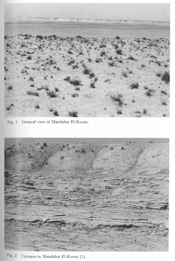 Plate 1.47 |
The basin floor is surrounded by a vertical cliff. The geology of the cliff in the southwestern part of the basin is as follows: 0.5 m thick, light brownish gray silt with angular subangular flint and marl gravels; 1.5 m thick, light brownish gray marl breccia; more than 5 m thick, marls. The relative height of the cliff is about 10 m at the outcrop, but generally reaches 15-20 m.
Four terraces are developed along the cliff. The upper surface is the plain of El-Koum. The second surface is 5 m lower than the first one. The third surface is 2.0-2.5 m lower than the second one. The fourth surface is 1.5 m lower than the third one. Finally, the basin floor is 0.8 m lower than the fourth surface (Plates 1.47: 2, 1. 48: 1). Except for the first terrace, the others are strath terraces without any deposits. The bedding of the marls declines gently toward the northwest. The terrace surfaces, like the marls, decline in the same direction. Isolated terraces are also distributed on the basin floor near the cliff (Plate 1.48: 2). Terrace-like steps of a relatively small size occur on the terrace cliffs (Plate 1.48: 2). These small cliffs are a rock-controlled topography. Headward erosion valleys occur in some places (Plate 1.49: 1).
 Plate 1.48 |
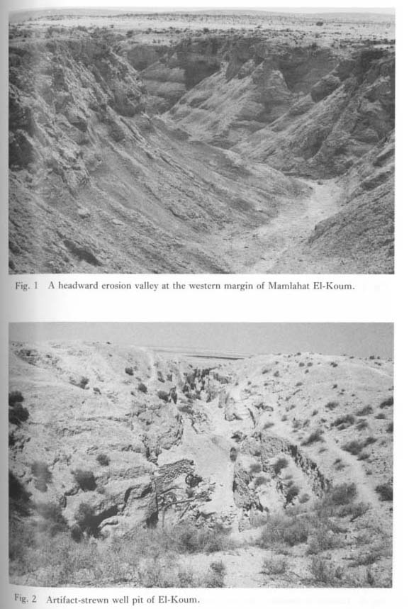 Plate 1.49 |
Such a multi-terraced topography can be explained only by the discontinuous lowering of the water level of a lake. Therefore, Mamlahat El-Koum was doubtless occupied by a lake in the past. However, the dates of the beginning of the lake and the terraces are not known. The cause of the coincidence of the inclination between the terrace surfaces and the bedding plain of the marls is also unclear.
Artifacts of the Hummelian, the initial stage of the Levantine Mousterian around 80,000 BP, have been found in the well pit at El-Koum (Plate 1.49: 2). Paleo-environmental investigations of Mamlahat El-Koum are also significant in elucidating the same problems in the Palmyra district.
2. Mamlahat Jeirud
Mamlahat Jeirud is a shallow closed depression about 60 km northeast of Damascus. The depression is 5.3 km in EW diameter and 3.9 km in NS diameter. The elevation of the surrounding plain is 790 m above sea level (from a 1/200,000 scale topographic map, 793 m above sea level). Its floor is 784m.
Two terraces developed in the depression (Plate 1.50: 1-2), whose floor is covered with gypsum crystals. Gypsum has been mined in recent years in several places on the floor. This depression was undoubtedly occupied by a lake in the past.
 Plate 1.50 |
One can clearly recognize the terrace topography in the eastern part of the basin. The upper terrace is 3-4 m high and consists of brownish-white silt and clay. The deposits are slightly gypseous but have few gypsum crystals. In the uppermost part a salt crust about 40 cm thick has formed.
The lower terrace consists of light gray silt and clay and is 2.0-3.5 m in relative height. The lower terrace deposits contain salt and gypsum crystals. A crust 30 cm. thick has formed at the top.
Artifacts of the Kebaran and the Natufian (10,000-12,000 BP) arc found on the upper terrace surface.
The dominant estimated wind direction in this district is southwest. North of the basin are many grayish-brown sand yardangs, with sandfields, barchans, and nebkahs of white gypsum sand scattered among them (Plates 1.51: 1-2, 1. 52: 1-2, 1. 53: 1). The white sandfield spreads far to the north of the dune-yardang zone (Plate 1.53: 2). The yardangs were formed by the erosion of large, old nebkahs which are inferred to have been formed by sand blown from the depression floor as the lake dried up. This is considered to have occurred after the PPN, judging from the data from the Palmyra Basin.
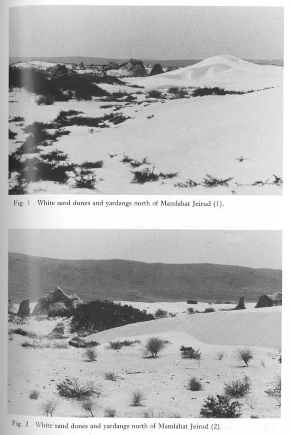 Plate 1.51 |
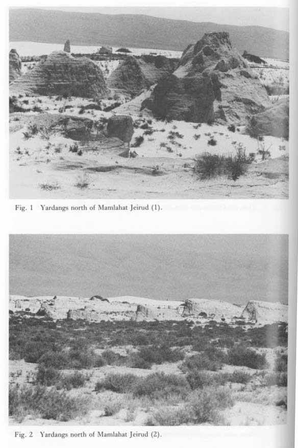 Plate 1.52 |
 Plate 1.53 |
The white sandfield continues to spread northward (Plate 1.53: 2). The formation of the sandfield is considered to be related to gypsum mining activities on the basin floor.
Acknowledgments
The author would like to thank Professor Minoru Utada of the University Museum of the University of Tokyo for investigating the mineral constituents of the samples from Bl. He also would like to express his appreciation to Professor Hideaki Ohba of the Museum for identifying plants collected from Sabkhet Mouh.
LITERATURE CITED
- Akagi, Y. (1973)
- Pediment escarpment retreat rate in the Huasco Area of the Atacama Desert, Chile. Ann. Tohoku Geogr. Ass., 25: 31-33.
- Akazawa, T. (1979)
- Prehistoric occurrences and chronology in Palmyra Basin, Syria. Univ. Mus., Univ. Tokyo, Bull., 16: 201-220.
- Ash, J. E. and Wasson, R. J. (1983)
- Vegetation and sand mobility in the Australian desert dune-field. Z. Geomorph. N.F., Suppl.-Bd., 45: 7-25.
- Assad, Kh. (1982)
- Some notes on the plants in and around Qasr-El-Heir. In I. Kobori, (ed.) Case Studies of Foggara Oases in the Algerian Sahara and Syria. The Tokyo University Scientific Mission for the Comparative Study of the Foggara Oasis in the Arid Zone of the Old Continent: Report Number Two, Tokyo: 91-95.
- Ass'ad, K. and Taha, O. (1966)
- Welcome to Palmyra. IV+111 pp.+1, Al-Incha Printing Office, Damascus.
- Birot, P. (1968)
- The Cycle of Erosion in Different Climates. 144 pp., B.T. Batsford Ltd., London.
- Browning, I. (1979)
- Palmyra. 223 pp., Chatto & Windus, London.
- Chapman, R. W. (1974)
- Calcareous duricrust in Al-Hasa, Saudi Arabia. Geol. Soc. Amer. Bull., 85: 119-130.
- Crouch, D. P. (1974)
- Use of aerial photography at Palmyra: A Photo essay. Berytus 1974: 71-104.
- Endo, B., Fujimoto, T., Akazawa, T, and Endo, K. (1978)
- Excavation at the Douara Cave. Umv. Mus., Univ. Tokyo, Bull., 16: 201-220.
- Endo, K. (1978)
- Stratigraphy and paleoenvironments of the deposits in and around the Douara Cave Site. Univ. Mus., Univ. Tokyo, Bull., 14: 53-81.
- Gasse, F. and Street, F. A. (1978)
- Late Quaternary lake-level fluctuations and environments of the northern Rift Valley and Afar Region (Ethiopia and Djibouti). Palaeogeogr., Palaeoclimatol., Palaeoecol., 24: 279-325.
- Goldberg, P. (1979)
- Micromorphology of sediments from Hayonim Cave, Israel, Catena, 6: 167-181.
- Henning, G. J., Grün, R. and Brunnacker, K. (1983)
- Speleothems, travertines, and paleoclimates. Quat. Res., 20: 1-29.
- Hesp, P. A. (1981)
- The Formation of shadow dunes. J. Sed. Petrol., 51: 101-112.
- King, L. C. (1953)
- Canons of landscape evolution. Bull. Geol. Soc. Amer., 64: 721-752.
- Koizumi, T. (1978)
- Climato-genetic landforms around Jabal ad Douara and its surroundings. Univ. Mvs., Univ. Tokyo, Bull., 14: 29-51.
- Leroi-Gourhan, Arl, (1974)
- Etudes palynologiques des derniers 11,000 ans en Syrie semi-deser-tique. Pal é orient, 2: 443-451.
- Leroi-Gourhan, Arl. (1980)
- Les analyses polliniques au Moyen-Orient. Pal é orient, 6: 79-91.
- Messeri, B. (1966)
- Das Problem der eiszeitlichen Vergletscherung am Libanon und Hermon. Z. Geomorph. N. F., 10: 37-68.
- Peng, T. H., Goddard, J. G. and Broecker, W. S. (1978)
- A direct comparison of 14C and 23Th ages at Searles Lake, California. Quat. Res., 9: 319-329.
- Richardson, J. L. and Richardson, A. F. (1972)
- History of an African Rift lake and its climatic implications. Ecol. Monographs, 42: 499-534.
- Sakaguchi, Y. (1978a)
- Palmyra pluvial lake-Paleogrography around the Paleolithic site of Douara-. Univ. Mus., Univ. Tokyo, Bull., 14: 5-28.
- Sakaguchi, Y. (1978b)
- Concluding remarks. Univ. Mus., Univ. Tokyo, Bull., 14: 107-110.
- Sakaguchi, Y. (1983)
- Warm and cold stages in the past 7600 years in Japan and their global correlation-Especially on climatic impacts to the global sea level changes and the ancient Japanese history. Bull. Dept. Geogr., Univ. Tokyo, 15: 1-31.
- Servant-Vildary, S. (1979)
- Paleolimnologie dcs lacs du bassin Tchadien au Quaternaire recent. Palaeoecol. Africa, 11: 65-78.
- Shaw, H. F. and Evans, G. (1984)
- The nature, distribution and origin of a sapropelic layer in sediments of the Cilicia Basin, northeastern Mediterranean. Marine Geology, 61: 1-12.
- Singer, A. and Ehrlich, A. (1978)
- Paleolimnology of a late Pleistocene-Holocene crater lake from the Golan Heights, eastern Mediterranean.J. Sed. Petrol., 48; 1331-1340.
- Singh, G., Joshi, R. D. and Singh, A. B. (1972)
- Stratigraphic and radiocarbon evidence for the age and development of three salt lake deposits in Rajasthan, India. Quat. Res., 2: 496-505.
- Street, F. A. and Grove, A. T. (1979)
- Global maps of lake-level fluctuations since 30,000 yr B.P. Quat. Res., 12:83-118.
- Tiercelin, J. J., Renaut, R. W., Delibrias, G., Le Fournier, J. and Bieda, S. (1981)
- Late Pleistocene and Holocene lake level fluctuations in the Lake Bogoria basin, northern Kenya Rift Valley. Palaeoecol. Africa, 13: 105-120.
- Twidale, C. R. (1967)
- Origin of the piedomont angle as evidenced in South Australia. J. Geol., 75: 393-411.
- Wasson, R. J., Rajaguru, S. N., Misra, V. N., Agrawal, D. P., Dhir, R, P., Singhvi, A. K., and Rao, K. K. (1983)
- Geomorphology, late Quaternary stratigraphy and palaeoclimatology of the Thar dunefield. Z. Geomorph. N. F., Suppl.-Bd., 45: 117-151.
- Wasson, R. J., Smith, G.I., and Agrawal, D. P. (1984)
- Late Quaternary sediments, minerals, and inferred geochemical history of Didwana Lake, Thar Desert, India. Palaeogeogr., Palaeoclimatol., Palaeoecol., 46: 345-372.
- Waters, M. R. (1983)
- Late Holocene lacustrine chronology and archaeology of ancient lake Cahuilla, California. Quat. Res., 19: 373-387.
- van Zeist, W. and Woldring, H. (1980)
- Holocene vegetation and climate of northwestern Syria. Palaeohistoria, 22: 112-125.
- van Zuiden, R. A. (1975)
- Calcrete. A review of concepts and an attempt to a new genetic classification. In Vogt, T. (ed.), Colloque "Types de croûtes calcawes et lew répartition régionale", UER de Géographic, Université Louis Pasteur, Strasbourg: 146pp.