CHAPTER III
General Geology of Country Rocks
|
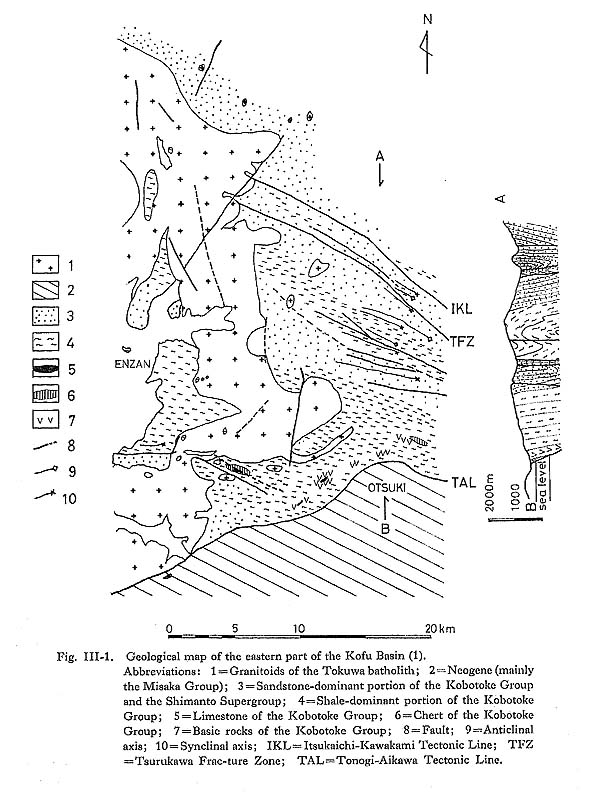
The Shimanto Belt (i.e., the southern part of the Butsuzo Tectonic Line in southwestern Japan and the Kanto Mountains) is in general divided into the Shimanto Belt in the strict sense (or the Shimanto Northern Belt) and the Setogawa-Nakamura Belt (or the Shimanto Southern Belt) (Kimura and Tokuyama, 1971; Kimura, 1974). The former is lithostrati-graphically referred to as the Shimanto Supergroup (Kimura, 1974) and the latter the Kobotoke Group in the Kanto Mountains. The rocks of the Kobotoke Group compose most of the country rocks of the Tokuwa batholith. 1) Shimanto SupergroupThe Shimanto Supergroup distributed in the Shimanto Northern Belt in the Kanto Mountains has also been called the Ogochi Group (Hujimoto, 1931) or the Otaki Group (Hujimoto et al., 1950). It is composed chiefly of medium to coarse massive sandstone containing shale fragments with some intercalations of black shale near the Tokuwa batholith. It generally strikes N20° to 60°W and dips 70° to the south, and is sometimes overturned. Most parts of the group are considered to be of Cretaceous age based on fossil evidence (Matsumoto, 1954); for example, Inoceramus amakusaensis Nagao and Matsumoto west of Yosawa, Kosuge Village has been reported (Nishimiya, 1976). The supergroup is assigned to the Upper Cretaceous. 2) Kobotoke GroupThe Kobotoke Group, defined by Hujimoto (1931), probably Eocene to Miocene in age (Y. Watanabe, 1984, pers. comm.), is widely distributed near the Tokuwa batholith. It is bound on the south by the Tonogi-Aikawa Tectonic Line from the Misaka and the Nishikatsura Groups and on the north by the Itsukaichi-Kawakami Tectonic Line from the Shimanto Supergroup (Fig. III-1). It is characteristic of terrigenous clastic rocks (Ogawa, 1981). It is chiefly composed of thick submarine slump and sliding deposits, alternating beds of shale and sandstone, and massive sandstone, in ascending order. It generally strikes N40° to 70°W and dips 50° to 80° to the north or 60° to 80° to the south. The estimated thickness of the group is less than 5,000 meters (m) as a whole. It is divided into three formations: the Lower, Middle, and Upper Formations (Table III-1).
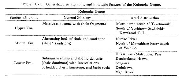
The Lower Formation is distributed from Hukashiro to the Matsuhime Pass, and at Kaminokamairisawa and Azagawa. It is composed mainly of submarine slump and sliding deposits with some intercalations of bedded chert, limestone, and basic rocks. The submarine slump and sliding deposits consist of lenticular breccias of bluish gray sandstone up to 2 m in diameter and a matrix of shale (Plate 1). Tuffaceous or siliceous shale occasionally occurs. Bedded chert is found only at Kadoisawa and Azagawa. Limestone occasionally occurs as small-scale lenticular or irregular bodies less than 10 m in maximum thickness. Many skarn minerals such as wollastonitc, diopside, grossular, vcsuvianite, epidote, and apophyllite occur inside the limestone at Kadoisawa due to intrusion of the Tokuwa batholith. Laterocavea sp. which is assigned to the Upper Cretaceous, was reported from one of the limestone blocks at Magi (Ishida, 1973). Basic rocks mainly consist of dark greenish to dark reddish purple basaltic tuff breccia with small amounts of basaltic sandstone, basaltic tuff, and andesidc tuff breccia. Basaltic sandstone at Magi is composed of Fe-pumpellyite, epidote, Ti-augitc, chlorite, albite, sphene, and calcite. The basic rocks in the Kobotoke Group arc weakly metamorphosed and enriched in pumpellyite and chlorite.
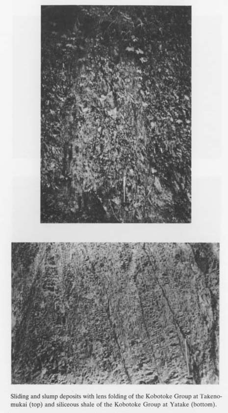
The Middle Formation can be traced at the Narako River and from near the Matsuhimc Pass to south of Yoshino, and is composed chiefly of alternating beds of dark gray shale and dark bluish gray to gray sandstone. Graded bedding and lens folds are occasionally observed in the sandstone. The thickness of each stratum is about 5 to 50 centimeters (cm). The Upper Formation is exposed from Mutsuhara to south of Takenomukai and from orth of the Matsuhime Pass to the Itsukaichi-Kawakami Tectonic Line. It is composed mainly of dark bluish gray to pale gray, medium- to coarse-grained massive sandstone containing shale fragments nearly parallel to the bedding plane. Some of the formation is upturned (Plate 2).
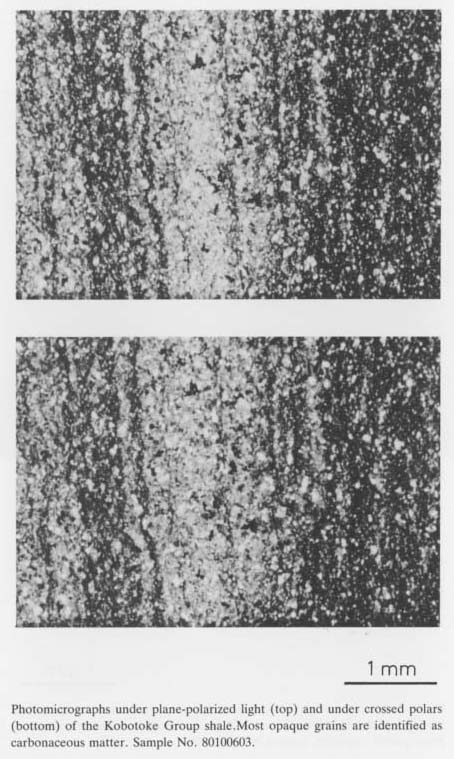
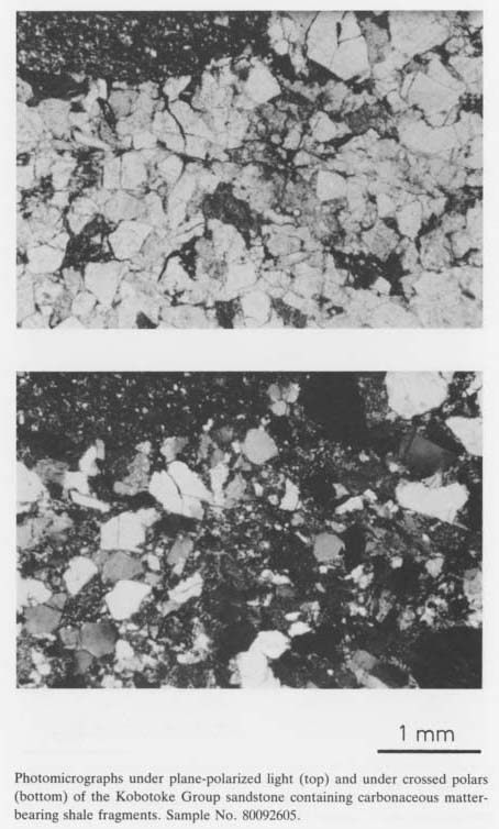
Carbonaceous matter is commonly observed in the shale (Plate 3) and occasionally in the sandstone (Plate 4) from the Kobotoke Group.
The Kobotoke Group is correlated with the Paleogene from the tectonic viewpoint (Kimura and Tokuyama, 1971). About 70 samples for radiolarian identification were collected from the group by the present author. The radialarian. fossil evidence suggests that the group is Tertiary in age (Nakaseko, 1982, pers. comm.). Xenoliths and hornfels derived from rocks of the group will be described later on. 3) Misaka and Nishikatsura GroupsThese are distributed in the southern area of the Tonogi-Aikawa Tectonic Line. The geologic structure is very complicated because of the development of various types of faults. The Misaka Group consists mainly of submarine andesitic pyroclastic rocks with some intercalations of clastic rocks and some intrusions such as of pyroxene andesite. These intrusive rocks with high values of magnetic susceptibility are commonly found in the group near the southern part which is in contact with the Tokuwa batholith. The time of deposition is inferred to be Late Miocene (Matsuda, 1962). Most of the Misaka Group rocks suffered regional metamorphism of zeolite fades after Miyashiro (1965). Zeolites are commonly observed in amygdules or druses of pyroclastic rocks. For example, heulandite, laumontite, analcime, calcite, and opaline quartz with small amounts of apophyllite, thomsonite, stellerite, and gyrolite are observed in two pyroxene andesite at Hatsukari, Otsuki City, and heulandite, analcime, chabazite, celadonite, and nontronite in andesitic tuff at Tsurushima, Uenohara Town. The Nishikatsura Group, first defined by Fukuta and Shinoda (1952), occurs in Otsuki City and consists of clastic rocks with intercalations of andesitic pyroclastic rocks. A thick conglomerate, composed mainly of pebbles (avg. 3 cm in diameter) derived from the Misaka Group and a matrix of dark gray to reddish gray, coarse sand, is also intercalated in this group along the Asari River and at Iwadono-san. 4) HornfelsSome of sedimentary rocks of the Kobotoke Group including shale, sandstone, and alternating beds of shale and sandstone with intercalations of limestone, chert, and basic rocks, were thermally metamorphosed by the intrusion of the Tokuwa batholith in Middle to Late Miocene time. They were transformed into biotite hornfels with small amounts of cordierite(-orthoclase)-biotite hornfels, muscovite-biotite hornfels, and cummingtonite-biotite hornfels. Morita (1970) reported the existence of sillimanite-bearing cordierite-biotite-muscovite hornfels about 1 km west of Koganesawa-yama. The width of the thermal aureole of biotite hornfels reaches a maximum 2 km from the contact between batholithic rocks and country rocks, Cordierite-bearing hornfels is occasionally observed several hundreds of meters from the contact. Biotite hornfels is composed of minute mosaics of biotite and quartz with smaller amounts of apatite, pyrrhotite, and occasionally porphyroblastic cordierite. The texture is generally very similar to that of xenoliths of sedimentary rocks in granitoids. |