HOLOCENE OSTRACODS IN THE SOUTHERN BOSO PENINSULA
Paul M. Frydl
Mobil Oil Canada Ltd., Calgary, Canada
General geology
|
Boso Peninsula projects from the northern third of Honshu for about 80 km into the Pacific Ocean, forming the northern flank of the Tokyo Bay. It is divided into the Northern, Central, and Southern Geological Provinces. The area under investigation in this study occupies the tip of the peninsula south of 35°15' N and nearly coincides with the Southern Geological Province (text-fig, 1). Siltstones of the Hota Group, which belong to the Central Geological Province, occur to a limited extent in the northern part of the area. The central and southern parts of the investigation area are occupied by low rounded hills (200 m) with flattened summits formed by rocks correlated with the Miura and Kazusa Groups. In the low lying flat coastal areas, the Neogene rocks are covered by a thin (0 to 40 m) veneer of unconsolidated Holocene sediments forming four marine terraces. The Neogene rocks are tightly folded, with fold axes trending southwest to northeast and south to east. Several active faults trending east to west are present in the northern part of the area.
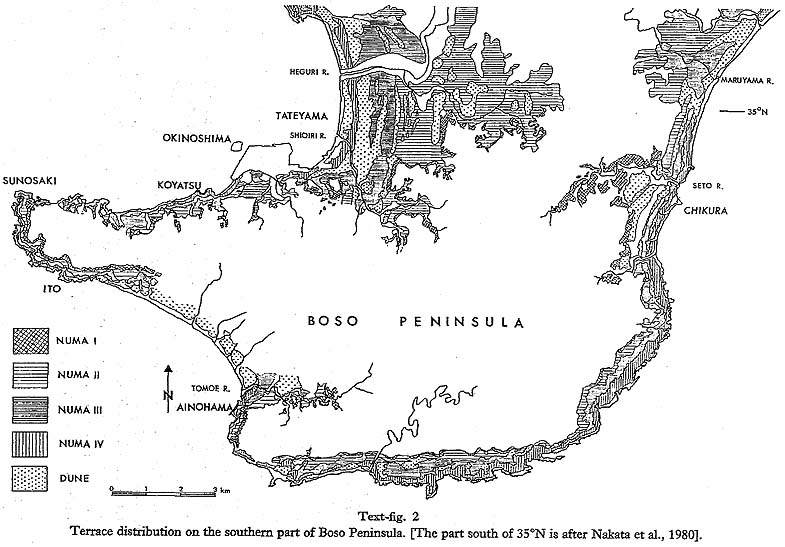
The center of the synclinorium is occupied by a siltstone-sandstone alternation of the Toyofusa Formation, which is correlated to the Kazusa Group and is separated from the Miura Group by an unconformity. Rocks of the Miura Group form the flanks of the synclinorium, with volcanic sandstone and mudstone-sandstone intercalation of the Chikura Formation in the southeast and soft siltstone of the Nishizaki Formation in the southwest. The unconsolidated Holocene sediments consist of marine silt and clay, partly overlain by and interfingering landward with nonmarine silt, clay, sand, and conglomerate. The marine sediments are the subject of the present study. Tectonic setting; The Boso Peninsula occupies a tectonically highly unstable area in the close proximity to the triple junction between the Philippines, Pacific, and Asian crustal plates. In historical times, it has been a site of several large earthquakes, two of which were of magnitude 8 on the present-day Richter scale. The two large earthquakes in the Genroku (1703) and Taisho (1923) eras were accompanied by considerable crustal deformation and destructive tsunamis. The southern part of the Boso Peninsula lies 20 km northeast of the junction between the Philippine and Asian plates, and both earthquakes resulted in an uplift of several meters. During the Genroku earthquake, maximum uplift reached 6 m, and locally the coastline retreated up to 800 m (Imamura, 1925), producing a 3 to 6 m high terrace girdling the southern part of the peninsula. During the Taisho earthquake, the uplift was smaller, reaching a maximum of 2 m (Omura, 1926). No terrace was produced, owing to the brevity of the interval preceding the second uplift. The amount of uplift was different in different parts of the southern Boso Peninsula, and areas of maximum uplift during the two earthquakes did not coincide. During the Genroku earthquake, the southeastern part of the area experienced the maximum uplift, while the area of minimum uplift was located in the norhthwest (Matsuda et al., 1978). The Taisho earthquake resulted in maximum uplift in the south and southwest and minimum uplift in the northeast (Omura, 1926). Rapid uplift during the earthquakes alternated with slow subsidence in the interim periods. Matsuda et al. (1978) estimated the rate of subsidence from 1703 to 1923 to be about 0.2 to 2 mm per year, resulting in a subsidence not exceeding 2 m. The present rate of subsidence in the southern part of Boso Peninsula is about 2 mm per year (Kanamori, 1973) and subsidence from 1923 to present amounts to 15 cm. The tsunamis generated by the Genroku earthquake were the highest in the south and southeast, exceeding an inundation height of 5 m. During the Taisho earthquake, tsunamis on the south coast again exceeded 5 m inundation height but were smaller than 2 m on the east coast. The west coast, that is Tateyama Bay, experienced only small tsunamis during both events; the inundation height was less than 5 m. Terraces: Several distinct marine terraces are developed along the coast of the southern part of the Boso Peninsula. In the northern part of the investigation area, depositional terraces form the surface of wide, low coastal plains extending over 5 km into the interior of the peninsula. On the southwest coast, narrow erosion terraces are incised into the Neogene rocks. Four well-defined terraces can be recognized (text-fig. 2). The surface of the highest terrace (Numa I) ranges from 20 to 25 m above sea level. C14 dates of shells and wood incorporated in the sediments forming this terrace indicate that it emerged about 5,000 to 6,000 yr B.P. The Numa I terrace is best preserved in the inner parts of long, narrow valleys (Tomoe River, Seto River) where it has been protected from marine erosion subsequent to its emergence.
The second highest terrace, the Numa II, lies between 17.5 and 12.5 m above sea level. The time of its emergence has been determined by C14 dating to be about 4,300 to 4,000 yr B.P. The surface of the extensive coastal plains of Tateyama City and the Maruyama River is formed by this terrace. Numa III, which emerged around 2,800 yr B.P., runs parallel to the coast averaging about 500 m in width. Its surface lies from 12.5 to 5.5 m above sea level. The lowest terrace, Numa IV, emerged during the uplift associated with the Genroku earthquake (1703). Its surface is highest in the southeast, where it lies 5 m above sea level and is lowest in the northwest, where it is found at 3 m above sea level. Sugimura and Naruse (1954) noted that the inclination apparent on the Numa IV terrace is paralleled by similar inclination trend of the older terraces, increasing in steepness with increasing age. It has been suggested that earthquake-related uplifts similar to that in 1703 are to a large extent responsible for the formation of the terraces (Nakata et al., 1980;Yonekura, 1975). |