We have obtained some interesting results concerning the paleogeography of the Palmyra region related to the Paleolithic site of the Douara Cave. These results are very important for Quaternary studies in the Syrian Desert. The author will try to pick up and discuss some common problems among the articles in our report and add some supplementary data and comments.
7. 1 ON THE CORRELATION OF THE TERRACES AND THEIR AGES
The author divided the lacustrine terraces around Sabkhet Mouh into 397m-, 387 m-, and 383 m-terraces, based on a standard shoreline elevation. However, it is also possible to consider that the 397 m-terrace was lowered by wind erosion, thus changing into the 387 m-terrace.
The 397 m-terrace can be definitely correlated to the middle terrace (S3) in the Douara Basin, because the deposits of both terraces include abraded Middle Paleolithic artifacts. The 397 m- and 383 m-terraces may be correlated to the middle terraces I and II respectively in the Douara Basin.
Akazawa found Late Acheulean artifacts on the surface of the terrace of Locality 72 in the Palmyra Basin, which is higher than the 397 m-terrace. This terrace is correlated to the higher terrace (S2) in the Douara Basin. The terrace which is located south of Locality 72 and higher than the terrace of Locality 72 may be correlated to the highest terrace (S1) in the Douara Basin.
According to Koizumi, the general topography of the Douara Basin was formed in the time of the higher terrace, that is, before the Middle Paleolithic age. This conclusion may be also applied to the case of the Palmyra Basin. The lower terrace in the Palmyra Basin was inferred to have been formed during the minor high level stage of the pluvial lake, which was correlated to the Epi-Paleolithic and Pre-Pottery Neolithic age. Therefore, this terrace can be definitely correlated to the lower terrace on which Pre-Pottery Neolithic artifacts were found.
Considering these results and the author's investigations at Wadi el Ahmar, Wadi Jaria, and Arak, it is concluded that the geomorphological succession is common in the Palmyra region.
7. 2 ON THE GENESIS OF THE TERRACE
The middle terrace in the Douara Basin is an accumulation terrace. The accumulation is inferred to have been brought about by two causes: an increase in transporting loads and a rise in the local base level of erosion, which was caused by the formation of the pluvial lake. If this inference is correct, the higher terrace in the Douara Basin and the correlated ones may offer a key to the solution of the problem of whether or not a lake existed in the time of the higher terrace. Therefore, the question of whether these terraces are filltop terraces or not is important. Koizumi considered that the higher terrace in the Douara Basin was an accumulation terrace. However, according to the author's investigations, the higher terrace in the Douara Basin is considered to be mostly a rock-cut terrace.
Koizumi considered that the down-cutting of the middle terrace surface was mainly caused by a decrease in transporting loads. However, it seems to be reasonable to conclude that the main cause was the lowering of the water level of the pluvial lake. The accumulation and the down-cutting of the lower terrace may also be explained by the minor fluctuations in the water level in the Epi-Paleolithic and the Pre-Pottery Neolithic ages.
7. 3 ON NEOTECTONICS DURING THE LATE
QUATERNARY IN THIS REGION
There is no certain evidence concerning crustal movements related to the development of the landforms in this region. However, the following data are suggestive in connection with this problem.
Three terraces are developed along Wadi Jaria at the foot of the southern slope of the eastern Jabal ad Douara (Locality 43). The longitudinal profiles of the upper and the middle terrace strikingly diverge toward the mountain. However, the middle terrace is excluded from consideration, because this terrace is a filltop one, and it is difficult to decide whether or not the inclination of its profile is an original dip. The upper terrace is a rock-cut one. The inclination of its profile is too steep. This situation may be caused by the uplift of the mountain.
There are four terraces along Wadi el-Ahmar at Locality 44, 3 km southwest of the Douara Cave. The surface of the highest terrace slightly inclines toward the north. The direction of the inclination coincides with that of its bedrock, the Pliocene conglomerates. This fact may also suggest that crustal movements occurred in this area.
Accordingly, it is possible to infer that crustal movements had taken place at least before the Middle Paleolithic age in Jabal ad Douara area.
7.4 ON THE ASYMMETRIC ARRANGEMENT OF THE
TOPOGRAPHY IN THE DOUARA BASIN
As shown in Fig. 3. 5 in Koizumi's article, some landform elements arrange asym metrically in the NS profile of the Douara Basin. The lowest part of the basin, which is through Wadi Khawabi el Kharrar and Wadi Jaria, is located near the southern margin: of the basin. The middle terrace is mostly distributed north of this lowest part. The taluses are developed along the foot of the south-facing scarp surrounding the basin, while the distribution of the pediments are restricted to the foot of the north and west-facing scarp. As Koizumi pointed out, this asymmetry seen in the pediment talus system is considered to have been caused by differential debris production depending on the direction of the scarp.
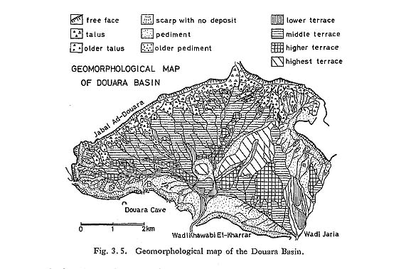
Though Koizumi inferred that the debris production was controlled by the dip of the strata consisting of the scarp surrounding the basin, the author considers that the asymmetry in this basin can be explained by differential insolation between opposite scarps. Insolation is greater on the south-facing scarp, where weathering has been more intense. In contrast, on the north-facing scarp insolation is much less, and weathering has proceeded much more slowly. The west-facing scarp is in the intermediate state between these two cases. If runoff takes place uniformly in a basin, produced debris is washed out from the whole area. Consequently, pediments are easily formed at the foot of the north-facing scarp, but debris remains to form taluses at the foot of the south-facing scarp. A fresh rock wall appears and then becomes more disintegrated. This process is repeated, and the south-facing scarp retreats rapidly. Why are taluses poor at the foot of the southern slope of Jabal ad Douara? Because this slope is a dip slope, and not so much debris is produced.
7. 5 ON THE PROBLEM OF LOCALITY 50
As previously mentioned, there is a discrepancy between the stratigraphy of the deposits seen on the well and the archeological spots found on the ground around the well. According to Fujimoto, the ages of these spots decrease in the following order: D and E (the stage V of the Upper Paleolithic age in Levant)-A (the well, the transi tional stage V / VI of the Upper Paleolithic age in Levant)-B, C, and F (the stage of the Geometric Kebaran A). Spots D and E are located on the gentle slope between 385 m and 386 m in elevation. Spots B, C, and F are located on the nearly horizontal ground between 384 m and 385 m in elevation. The artifacts-bearing strata at Spot A are considered to be secondary in origin. If the following inference is correct, the relation between the ages of the spots and the topography may be explained without contradiction, The artifacts of Spot A were transported from a primary spot located on the slope where Spots D and E are situated, then deposited at Spot A. Later, Spots B and C were located on the ground immediately north of Spot A.
The crust around Palmyra does not contain any artifacts more recent than the Epi-Paleolithic. However, the ground of Spots B to F is not encrusted. The result obtained from the Ghab pollen diagram and the deposition of the Fan gravels I and II at the foot of Douara Cave obtained by K. Endo's investigation are suitable for considering that the Pre-Pottery Neolithic age was humid and the crust around Palmyra was formed during this time. However, this consideration is contradictory to the situation of Locality 50. The crust formation may have taken place twice or more times,
7. 6 ON THE PALEOCLIMATE RELATED TO THE
PALEOLITHIC SITE OF DOUARA CAVE
Among eleven radiocarbon dates of the samples obtained from Douara Cave in the 1974 season, ten dates are over the determination limit of 43,000 y. (TK) or 52,000 y. (GrN). Meanwhile, the travertine taken from the ground of the innermost minor cave of Douara Cave was dated at 70,000 F.T.y. by M. Suzuki (personal communication). Considering these dates, the age of the cave is surely more than 50,000 years.
According to Suzuki, the gypsum crystal taken from the deposits of the 397 mterrace was dated at 70,000 y.B.P. by the fission-track dating method. This date supports the author's inference that the Paleo-Palmyra Lake is older than 45,000 years.
From the investigations independently carried out by each investigator in the Palmyra and Douara Basins, we have reached the same conclusion on the paleoclimate related to the Paleolithic site of Douara Cave. Summarizing our results, the Middle Paleolithic age in this region was rainy and cool in the summer, and in the winter colder than today. In the last glacial period, the snowline in the Lebanese Mountains is estimated to have been lowered by 1050 to 1350 (?) m (Kaiser, 1963) or 1000 m (Messerii, 1967). If the lowering of the snowline depended on the temperature only, the lowering of the temperature in the last glacial period may be 5.5 to 7.5°C. Recently the lowering of the temperature by 15°C has been inferred by an investigation at Mt. Hermon, the Anti-Lebanese Mountains (Gvirtzman, 1976).
LITERATURE CITE
- Gvirtzman, G. (1976)
- Late Würm temperature depression in the Middle East -15°C: Evidence from fossil snowlines on Mount Hermon and Jebel Catharina, Sinai. Proceedings IGC, Moskva, 2: 295-297.
- Kaiser, K. (1963)
- Die Ausdehnung der Vergletscherung und "periglazialen" Erscheinungen wahrend der Kaltzeiten des quartären Eiszeitalters innerhalb der syrisch-libanesischen Gebirge und die Lage der klimatischen Schneegrenze zur Würmeiszeit im östlichen Mittel meergebiet. Proceedings INQUA, Warsaw, 127-148.
- Messerli, B. (1967)
- Die eiszeitliche und die gegenwärtige Vergletscherung im Mittelmeer raum. Geographica Helvetica, 22: 105-228.