2.1 INTRODUCTION
The author participated in the excavation of Douara Cave, carried out from August through November 1974, as a member of the Fifth Tokyo University Scientific Expedition to Western Asia, and investigated landforms around the cave in order to reconstruct the environments in which the ancient inhabitants of the Douara area lived.
The Douara Cave, correctly called the Douara Cave I, is located at 34°38.5'N
and 38°27.5'E, about 20 km northeast of Palmyra (Tudmor), and situated
at the lower part of the southern slope of Jabal ad Douara (Dawwara), which
means a ring-shaped mountain in Arabic (Figs, 2. 1 nd 2. 2). The elevation
of the floor of the cave is 552.8 m. his value was obtained by a levelling
started from he bench mark of Tell el-Munssef Fig. 2. 2). Douara Cave was
first excavated in 1970 by the Fourth Tokyo Uiversity Expedition, and various
related investigations were carried out in the field and in the laboratory.
Some results of the physical-geographical investigations have already been
published (Suzuki and Takai, 1973).


What was the most impressive change in the landscape in the arid zone during the late Quaternary? It was the growth and decay of pluvial lakes. The pluvial lake is one of the most reliable records of climatic changes during the Quaternary in the present desert zone. It is the purpose of this paper to point out the appearance of pluvial lakes and climatic fluctuations in Palmyra region.
Palmyra, an oasis town which is a famous ruin from the Roman period, is
located on the eastern foot of the Southern Palmyra Mountains, which extend
from the southwest to the northeast. The main portion of Palmyra is 400 to
420 m above sea level. South of Palmyra there extends a vast playa called
the Sabkhet Mouh. In this paper we call a spindle-shaped closed depression,
which is surrounded by the main ranges of the Southern Palmyra Mountains,
Jabal el-Abtar, and Tieilet ad-Dab'a, the Palmyra Basin. Its length and maximum
width are about 70 km and 35 km, respectively. The lowest portion of the basin
is less than 370 m above sea level. The lowest divide of this basin is situated
at the eastern end of the basin and lies between 400 and 410 m in elevation.
The Palmyra Basin is considered to have been formed by the intersection of
a set of down-warpings, whose axes extend from the northeast to the southwest
and from the east to the west, judging from its outline. The mountains and
hills surrounding the basin mainly consist of limestone and marl of various
geologic ages: Jurassic, Cretaceous, and Tertiary (Fig. 2. 3).

A branch of the Southern Palmyra Mountains, which extends to the NE or NNE from Adayyeh, plunges into the Sabkhet Mouh to form "small peninsulas" and "islets." In this paper, this area east of Adayyeh is called the Islets area.
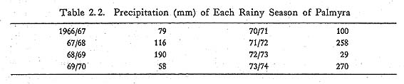
The warmest and the coldest months at Palmyra are August and January. Their
average monthly temperatures during the period from 1955 to 1966 were 30°C
and 7°C, respectively (Wirth, 1971). The average annual precipitation
is 125 mm, but it fluctuates conspicuously from year to year. The maximum
and minimum values in the nine years from 1966 through 1974 were 269 mm in
1974 and 66 mm in 1973 (Table 2. 1). The vegetational landscape of the basin
is semi-desert. However, because of the extraordi narily rainy and snowy winter
of 1973/74 (Table 2. 2), we could still find green vegetation everywhere in
the basin, though our excavation took place in the dry season.

In the Sabkhet Mouh, there are deposits of gypsum and halite. Halite deposits
occur especially around Ash-Shajara (Locality 19, et al.). The Sabkhet Mouh
is surrounded by pediments and alluvial fans, whose lower parts gradually
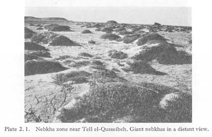
change to terraces. The zonal flat between the terrace cliffs and the playa
is densely covered by vegetated, mound-like sand dunes, called nebkhas (Fig.
2. 4, Plate 2. 1).

There are no perennial superficial flows in the basin. The wadis from the Southern Palmyra Mountains are relatively short but active in fluvial processes compared with those from the southern hill areas.
Lacustrine deposits are widely distributed throughout Syria, as shown in Fig. 2.1 (Ponikarov, 1967). Though some discussions have been made concerning pluvial lakes in the Damascus Basin (Ponikarov, 1967; Kaiser et al., 1973), there is no report on the Palmyra Basin. The field surveys of this season were limited to the western half of the basin because of a shortage of time and because the area east of Palmyra is off-limits.
2.2 SABKHET MOUH
Sabkhet Mouh was filled with water in 1974, because the precipitation in
the winter of 1973/74 was extremely abundant, as previously mentioned. The
water level of the playa lake had gone down considerably due to evaporation
at the end of August, when we arrived there. Though the lake had nearly disappeared
in the portion west of Ash-Shajara by the end of October, water still remained
in the eastern Sabkhet Mouh (Plate 2.2).

The maximum water level of this playa lake was easily determined by plant
remains and dung of sheep or camels, which had accumulated along the shoreline
by waves, and its elevation was determined to be 377 m above sea level by
a levelling based on the bench mark (387 m) south of Palmyra (Figs. 2. 2 and
2.13). Parallel stripes of small wave-built terraces consisting of coarse
sand and pebble remained along the maximum shoreline (Plate 2. 3). A low cliff
less than 1 m high had been formed by wave action in the nebkha zone between
Tell el-Qusseibeh and Ash-Shajara.


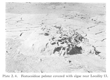
The deposits of the playa lake of 1974 consisted of brown, blackish gray,
or reddish brown sticky mud 5 cm thick, overlying compactly deposited sand.
The dried mud surface was cracked and partly covered with algae or salt. Festucoideae
polsters, which had grown on the playa surface before the water stagnated,
were covered by sheet-like algal assemblages which were coated with mud particles
on the outer side (Plate 2. 4). In places, the nebkhas had been completely
eroded by the waves and their traces remained as white patches on the dark
colored ground.
According to the observation of the pit wall, dug near the maximum water
level of 1974, at Locality 21, south of Palmyra, the sand bed below the mud
consisted of finer grains and included enriched horizons of gypsum crystals
1 to 7 cm thick at intervals of 3 to 30 cm (Fig. 2. 5). The gypsum crystals
were usually several millimeters in size, but in places were more than 3 cm.
Such a pure mud layer, as deposited in 1974, was not found in this profile.
It is not clear whether such a mud layer was completely eroded before the
appearance of the following playa lake, or whether it was not deposited at
all until recently.

The groundwater table at Locality 21 was 103 cm below the surface on Sept. 4, 1974. According to a farmer, the water table of the well in his date-palm garden, situated on a terrace north of Locality 21, was 21 m below the surface, that is, 2 m higher than usual.
A nebkha is a sand dune whose leeward slope is covered with vegetation. Neal and Motts (1967) have called such a sand dune in the western United States a phreatophyte mound. The nebkhas of Sabkhet Mouh are usually oval in slope. Their length ranges from several tens of centimeters to ten meters, and their height ranges from several tens of centimeters to five meters. The flank of a nebkha rises sharply to the sur-rounding plain, unlike an ordinary sand dune. Its vegetated leeward slope is parti-cularly steep. In this case, vegetation plays an important role in obstructing drifting sand and helping a nebkha to grow; it is not a proof of its fixation. The nebkhas occur in groups. From a distance, they look like the backs of a flock of sheep. The nebkhas usually extend from the east to the west or from the northwest to the southeast. However, some nebkhas extend from the north to the south and incline steeply to the west.
Giant nebkhas about 10 m long and about 6 m high are scattered near Tell
el-Qusseibeh (Plates 2. 1 and 2. 5). They extend from the east to the west
or from. the north-west to the southeast like ordinary nebkhas. It is said
that such giant nebkhas were not be seen several decades ago.
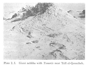
Generally, the vegetation on the steep slopes of the nebkhas is closely related with the developmental stages. In Sabkhet Mouh Arthrocnemum glaucum and Frankenia pulverulenta(?) characteristically appear on nebkhas less than 30cm high. The former grows exclusively on nebkhas 50 to 100 cm high. Meanwhile, Tamarix grows exclu-sively on the giant nebkhas. It is said that a period of 25 to 30 years is necessary for Tamarix to grow up to 2 m.
Vegetation is poor or non-existent on the gentle windward slopes of the nebkhas. A thin crust 2 cm thick with rain prints often forms on the surface (Plate 2.1), and in places is covered by fresh eolian sand. Such a crust seems to be formed year to year by vigorous evaporation during a dry season. Such annual crusts are exposed on the eroded flank of the giant nebkhas (Plate 2. 5). The columnar profile of Locality 22 in Fig. 2. 5 shows the inner structure of a nebkha. A is fresh eolian sand. B is the crust, formed definitely in 1974. C is eolian sand, in which remains of Arthrocnemum glancum are buried at intervals of 5 to 8 cm. E is correlated with B of Locality 21. As the eolian sand between two successive horizons of plant remains is considered to have accumulated in a year, the nebkha is estimated to have been formed during the preceding 10 years or so. Therefore, it is concluded that the maximum shoreline of the playa lake in Sabkhet Mouh retreated from Locality 22 to Locality 21, that is, 500 m, during this time.
Wind direction in the Palmyra Basin during the excavation varied according
to the locality. The dominant direction at the front of Douara Cave was SW
to WSW in the day and NE to ENE in the night from the end of August to the
end of October 1974. However, the easterly or southerly winds are strong and
dusty near Douara Cave. Such strong winds are effective in forming nebkhas.
The wind directions observed near Douara Cave coincided with those estimated
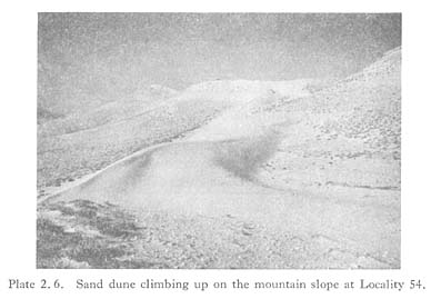
from some features of the nebkhas. Also, a snake-like sand dune ridge climbs
up in a NE direction along the southern flank of the Southern Palmyra Mountains
west of Palmyra (Locality 54; Plate 2. 6). This sand dune is actively moving,
and seems to be very young. The dune-forming wind is also southerly. We can
see several patched sand fields, which climb up the mountain slopes behind
the ruin of Palmyra and shine blond-colored in the sun.
2. 3 EVIDENCE OF THE PLUVIAL LAKE
2. 3. 1 Terrace topography and terrace deposits
As previously mentioned, terrace topography is recognized everywhere around Sabkhet Mouh, being especially conspicuous at Palmyra, Adayyeh, the Islets area, Al-Qleib, and Tlool at-Tleileh.
a) Adayyeh area
Locality 14. There are three terraces, 5.6 m, 2.0 m, and 0.6 m higher than the ad-jacent wadi floor. The lowest terrace has no deposits. The deposits of the middle ter-race consist of gravel and yellowish-white fine sand with gypsum crystals, overlying yellowish-white hard laminated silt. The total thickness is more than 50 cm. This ter-race is covered by a stone pavement, which consists of angular to subangular quartzite gravel with a maximum diameter of 10 cm. The aerated surface of this gravel is coated with desert varnish. The deposits of the upper terrace are angular to subangular gravel with a maximum diameter of 20 cm, fine sand, and silt. The gravel mainly consists of limestone, rarely flint. No quartzite gravel exists on the upper terrace.
Locality 23. The elevation of this terrace is probably 390 to 400 m. A clear terrace cliff 8 m high is formed at the eastern end. The surface is covered by a stone pavement, consisting of rounded to angular limestone and flint gravel coated with desert varnish. The terrace deposits consist of light grayish brown to light yellowish gray silt with gravel 4 m thick, lying on weathered marl. The uppermost part of the deposits is indurated. These deposits gradually change to a gravel bed lying on conglomerates or sandstone towards the mountains.
b) Islets area (Fig. 2. 6)
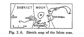
- Locality 27 (Tell el-Qusseibeh; Fig. 2. 7). This tell (or tall, small hill in Arabic) is the smallest among the isolated hills in the Islets area. The tell is flat-topped and surrounded by a steep slope. Two terrace surfaces are recognized at 12.5 m (389.5 m a. s. 1.) and 6.0 m (383 m a. s. 1.) above the maximum water level of 1974. The stone pavement of the upper terrace mainly consists of flint gravel and rounded flat limestone gravel with ammonite fossils with a maximum diameter of 20 cm. The deposits of the upper and the lower terraces are 2.8 m and more than 4m thick, respectively, and their features are as follows:
- A 15 cm, light brownish white crust including gypsum crystals and well-rounded flat gravel with a maximum diameter of 10 cm.
- B 65 cm, light grayish-yellow sand and silt with gravel. Crumb structure.
- C 200 cm, subangular to subrounded flint or limestone gravel with a maximum
diameter of 10 cm.
- D bed rock, yellow friable marl. The uppermost part, 30 cm thick, is weathered and includes a gypsum crystal band.
- E more than 110 cm, yellowish-white gypseous fine sand and silt and gravel with a maximum diameter of 10 cm.
- F 30 cm, yellowish-white fine sand and silt with gypsum crystals. Crumb struc-ture.
- G 60 cm, gravel.

Locality 30. This tell is situated 1 km north of Tell el-Qusseibeh. There are also two terraces 10 m and 6 m above the maximum water level of 1974. Their absolute heights are 387 m and 383 m, respectively. Both terrace deposits are yellowish-white gypseous sand with gravel, and are covered by the stone pavement.
Locality 25 (Plate 2. 3). Two terraces are recognized 9 m and 5 m high above the maximum water level of 1974. Their deposits are similar to Locality 27. The deposits of the upper terrace are 2 m thick, consisting of yellowish-white gypseous fine sand and silt with gravel, overlying the bed rock of marl. Some gravel is coated by Fe2O3 or sulphur. The terrace surface is covered by the stone pavement, consisting of angular flint gravel and rounded flat gravel with a maximum diameter of 20 cm. The surface of the lower terrace is also covered by the stone pavement, the gravel of which is about 8 cm in maximum diameter. The terrace deposits are yellowish-white gypseous fine sand and silt with gravel, more than 1 m thick.
Rounded flat gravel exists on all the above-mentioned terraces. Rounded flat gravel is common along the shore of a sea or a lake. Fine-grained sediments of fine sand or silt are also dominant in these terrace deposits. Consequently, these terraces are con-cluded to be lacustrine. Al-Qleib (Locality 28) is full of mesa-like flat-topped small hills 1.5 to 2 m high, consisting of light brown gypseous silt. A crust 15 to 20 cm thick has formed at the top of the deposits. No gravel is recognized here. The elevation of the hill top is estimated to be about 382 m. This area is inferred to be a dissected lacus-trine plain, judging from topographic features.
The bed rocks of the isolated hills in the Islets area are marl. Limestone and flint gravels, which make the stone pavements, are exposed west of this area, near Adayyeh. This fact shows that the isolated hills and the surroundings of Adayyeh were formerly connected to each other to form a lacustrine plain. The varnish-coated quartzite gravel is only found on the lower terrace at Adayyeh. At Locality 20 of Ash-Shajara such gravel is also found on the lower terrace. The quartzite bed is exposed west of Locality 14. This bed may have been first exposed during the formative period of the lower terrace surface. The gravel may have been derived from this bed, and transported as far as Ash-Shajara in the same period.
c) Palmyra area
Locality 47. A confluent fan, formed by Wadi Abou Obeid and Wadi A'id, on which the town and the ruin of Palmyra are situated, changes to a terrace, having a steep cliff 3.5 to 4m high at Locality 55. At Localities 46 and 55a the terrace is dissected to form some isolated hills 3 to 5.5 m high. The shallow valleys and cliffs of this area extend from the northwest to the southeast. The cause of this tendency is not yet clear, but may be related to wind erosion, judging from the dominant wind direction here. The deposits of this area are similar to those in the southwestern Sabkhet Mouh.
- The vicinity of Locality 47 is the southeastern Necropolis of the Roman period (Plate 2. 7). The following depositional sequence is seen on the wall of an excavated under-ground tomb (Fig. 2. 8):
- A 120 cm, yellowish-gray silt with gravel.
- B 120 to 130cm, subangular to rounded gravel with a maximum diameter of 20 cm.
- C 150 cm, yellowish-gray silt with lenses of gravel.
- D 20 cm, gravel.
- E 250 cm, yellowish-gray hard silt with gravel, including lenses of gravel and cross-bedded sand.
- F 120 cm, hard salty silt.
- G 80 cm, organic clayey silt. The absolute height of the lower boundary is 389.5 m. Radiocarbon dates; 1,860 ± 70 (TK-164) and 1,930 ± 30 (GrN-7593).

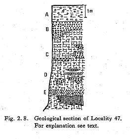
A Middle Paleolithic flake was found in fallen earth from the nitch wall. An abraded Middle Paleolithic artifact was also found in fallen earth at the base of the cliff of Wadi A'id at Locality 47a. Trace fossils were found in the silt layer outcropped along Wadi A'id.
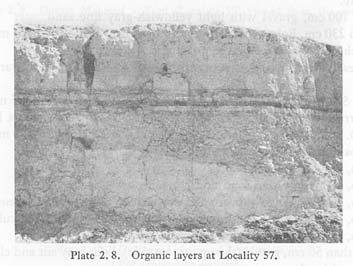
- Locality 57. This locality is the cliff of Wadi A'id, situated 300 m upward of Locality 47a (Plate 2. 8). The features of the deposits are as follows (Fig. 2. 9):
- A 95 cm, light brownish-yellow to light brownish-gray eolian fine sand.
- B 5 cm, blackish-gray organic clayey silt.
- C 5 cm, light brownish-gray fine sand.
- D 5 to 6 cm, blackish-gray organic clayey silt.
- E 10 cm, grayish-yellow clayey silt, fine cubic structure.
- F 10 cm, blackish-gray organic clayey silt. Three dark bands are seen. Radio-carbon dates; 18,900 ± 200 y.B.P. (TK-150) and 19,410 ± 150 y.B.P. (GrN-7597).
- G 10 cm, light grayish-brown fine sand. Lower partly organic.
- H 5 to 10 cm, light yellowish-gray silty fine sand, slightly organic, fine cubic structure.
- I 50 to 100 cm, gravel with light yellowish-gray fine sand.
- J 120 to 230 cm, light yellowish-gray to light brownish-gray hard massive clayey silt, including lenses of gravel, prismatic structure.
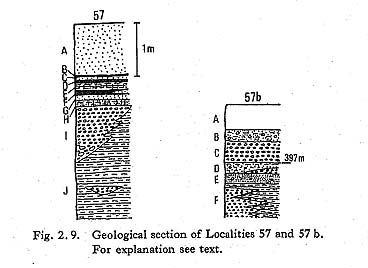
F layer is nearly horizontal between Locality 57 and 57a, 61.5 m upward of Locality 57.
At Locality 57a three terraces are recognized at heights of 1.5 m, 2.5 m, and 4.5 m. The lowest terrace disappears 365 m upward of this locality to make a knick point.
- Locality 57b. This locality is situated at the cliff of Wadi A'id 290m up Locality 57a. The depositional sequence is as follows (Fig. 2. 9):
- A 50 cm, surface soils.
- B 20 cm, light gray fine sand and silt with gravel.
- C 40 cm, subangular to subrounded gravel with a maximum diameter of 10 cm.
- D 20 cm, light gray silt and fine sand with lenses of gravel, fine cubic structure.
- E 20 cm, light gray laminated fine sand with gravel.
- F more than 50 cm, gravel (the up-stream side), light gray silt and clay, fine cubic structure (the down-stream side).
It was concluded that the fine sand, silt, and clay deposited at Localities 47 to 57b were telmatic and lacustrine sediments which had been strongly affected by fluvial processes.
A palynological study was made concerning the organic clayey silts at Localities 47 and 57 by Dr. W. van Zeist, University of Groningen, but pollen grains were very rare and undeterminable.
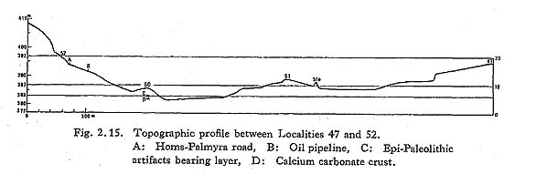
Near Localities 50 and 52.5 km southwest of Palmyra, there are terraces contiguous with the pediment formed at the foot of the Southern Palmyra Mountains. The terrace cliff is not so clear at Locality 50. However, a distinct terrace cliff appears 500 m west of this locality. On the terrace surface a thick calcium carbonate crust is formed. The 80-m-wide flat along the foot of the terrace cliff is strewn with angular gravel and many artifacts.
- Locality 50. This locality is a former oasis called Ouinat Mohmed el-Fard (Plate 2. 9). A well for irrigation is dug on the terrace. Its water table is 270 cm below the surface. The depositional sequence of the sediments seen on the well side is as follows (Fig. 2.10):
- A 65 cm, light reddish-brown to light grayish-brown laminated medium to fine
sand.
- B 30 to 40 cm, light gray mottled fine to medium sand with gravel, plentiful plant remains, sand blocks including arrtifacts (C). The radiocarbon date of the Phoenix bark lying at the lower boundary is 38,450 ± 650 y.B.P. (GrN-7598).
- D 40 cm, light brownish-gray fine to medium sand.
- E 60 cm, light gray fine to medium sand, fragments of the crust, lower part light gray clayey fine to medium sand (F).
- G 20 cm, light gray medium to fine sand with plant remains.
- H 50 cm, light gray fine to medium sand, many artifacts and some animal bones.
- I 30 cm, dark gray hard medium to fine sand.
- J 70 cm, blocks of the crust.
- K calcium carbonate crust.


The artifacts collected from these deposits belong to the Kebaran and the Neolithic ages. On the terrace immediately north and east of this well many artifacts which belong to the Kebaran and the Geometric Kebaran ages, were collected. The elevation of the top of the crust (K) is 382 m.
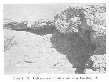
Locality 52. There are two wells, called A and B, immediately north of the
Homs-Palmyra road. Well B has collapsed, but well A is now used for irrigation
of the palm garden, situated south of the road. A calcium carbonate crust
has formed all over the surface between the road and a knick point at the
foot of the mountains shown in Fig. 2. 11 (Plate 2. 10). The crust in this
locality consists of light gray fine sand indurated by calcium carbonate.
The crust is so hard that a hammer is necessary to pick out a piece. The crust
usually has a platy structure and in part, moreover, a honeycomb structure.
A number of artifacts of the Epi-Paleolithic, Pre-Pottery Neolithic A and
B stages and of the Middle Paleolithic type are found in the crust around
well B.

- Well A is 5 m in diameter. Its water table is 5 m deep and mostly covered with reeds. The boundary between the terrace deposits and the bed rock outcrops is immediately above the water table. The groundwater springs out from two outlets on the boundary. Well A is connected by a tunnel with the palm garden. The depositional sequence on the wall of the tunnel is as follows (Fig. 2. 12):
- A 150 cm, light gray fine sand with gravel, artificial.
- B 60 cm, light gray to light brownish-gray encrusted sand containing artifacts.
- D is a piece of treated stone of the Roman period.
- C more than 200 cm, light gray to white salty fine sand. The middle part is remarkably salty and laminated.

C layer is inferred to be lacustrine, based on its lithologic features. This layer has no gravel, thus differing from the other localities of Palmyra. Light brownish-gray to light gray laminated fine sand 110 cm thick is lying on the crust. This sand is slightly indurated, but can be easily crushed by kicking.
2. 3. 2 Fossil river months
Snake-like hills extend like fingers towards the south from the Palmyra confluent fan as shown in Fig. 2.13. Their absolute height ranges from 380 to 390 m. The hills are 1.5 km long, 50 m wide, and 5.5 m high in maximum value. They trend from N30°E to N40°W, The western hills are higher than the eastern ones in relative height. At Locality 56, the relative height decreases toward the south, that is, 2.5 m at the north end, but 1 m at the south end 500 m from the north end. These hills consist of light brownish-gray fine sand or silt including well-rounded to subangular gravel. Their surface is covered by a stone pavement. At Locality 51a flat gravel is included in the stone pavement. The maximum diameter of the gravel is 20 cm at Locality 51. At Locality 55 the gravel size decreases toward the south, that is, 15 cm at the north end, and 8 cm at the south end 490 m from the north end. At Localities 51 and 51a, a terrace is formed at the middle of the hill slope. The hill slope at Locality 51a is slightly dissected by shallow valleys. At Locality 51b the eroded hill remains as a flat sand field.
These hills are former distributary river beds, which extended into a lake like the typical bird's foot delta of the Mississippi River. A number of Middle Paleolithic and post-Middle Paleolithic artifacts are found on the hills. The former are abraded, but the latter are fresh. The river mouths are inferred to have stopped their growth in the Middle Paleolithic age or soon after its end. The end of growth may have been caused by a decrease in fluvial action and/or the disappearance of a lake due to climatic changes.
2. 3. 3 Conclusion
As previously mentioned, the landforms and the deposits. of Sabkhet Mouh and its surroundings coincide with each other on a lacustrine origin. A diatom analysis was tentatively carried out on some of the samples collected from the main localities; how-ever, no diatom was found in them. Nevertheless, it is certain that a pluvial lake existed at least in the Paleolithic ages in the Palmyra Basin. The absence of diatom remains may be explained by dissolution of the diatom frustules after death, because of the high pH value of the pluvial lake, like Lake Victoria (Kendall, 1969). The lake is called the Paleo-Palmyra Lake.
2. 4 HISTORY OF THE LAKE AND CLIMATIC CHANGES
Judging from the geological data of Locality 57, the lake existed about 19,000 years ago. It is concluded that its water level lay at 397m above sea level, as the boundary between the C layer of fluvial facies and the D layer of lacustrine facies lies at the same level.
Also, the organic clayey silt at Locality 47 lies 5 m lower than the organic layers at Locality 57. Both of the radiocarbon dates are too young. The dates coincide with the age of the underground tomb. The discordance between the stratigraphy and the dates may be caused by the following: 1) the original sequence of the deposits was disturbed when the underground tomb was constructed; 2) carbon exchanges took place between the organic matter of the deposits and bodies buried in the Roman period, because they came into contact with each other.
The author does not have sufficient data to conclude whether or not a lake existed more than 19,000 years ago. A piece of Phoenix bark found at the well of Locality 50 is suggestive regarding this problem. The radiocarbon date of this bark is 38,500 y.B.P. This bark was probably transported at the time of a flood and buried here. The stand of Phoenix is surely between Locality 50 and the mountain 1 km from this locality. For the stand of Phoenix, a high groundwater table seems to be suitable. Such a place may be Locality 52, where the groundwater springs out now. The present water table of this locality is very low. If the lake surface were as high as 395 to 400 m, the water table would lie near the ground surface. It is considered that the dated bark was brought from Phoenix growing at Locality 52 under such a condition. A lake probably also existed 38,500 years ago.
According to the palynological studies on the llm thick deposits of the Ghab de-pression, western Syria, a low percentage of non-arboreal pollen appears at the pollen assemblage zone (T) 8.5 to 9.5 m deep. The age of this zone is inferred to be more than 45,000 years. J. Niklewski and W. van Zeist (1970) concluded that at that time the climate would have been at least as moist as it is today, and temperatures would have been lower than at present. The birth of the Paleo-Palmyra Lake could go back to this time. In the Damascus Basin pluvial lakes were formed twice during the Quaternary, that is, in the Riss and Würm ages. However, a pluvial lake in the Riss age is not yet confirmed in the Palmyra Basin.
The water level of the lake 38,500 y.B.P. is estimated to have been about
395 to 400 m above sea level. According to the topographic map, the elevation
of the lowest divide of the Palmyra Basin is between 400 and 410 m. Therefore,
the water level of the lake cannot exceed this elevation. This fact is consistent
with the geological data on Sabkhet Mouh and its surroundings. However, if
the lowest shallow and wide divide facing T-3 resulted from erosion or downwarping,
one can hypothesize that the maximum lake level was higher than 400 m in the
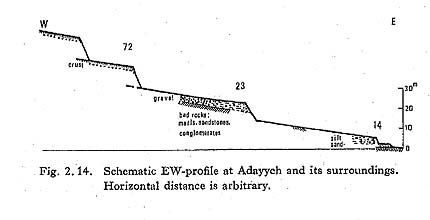
Palmyra Basin. At Locality 72 the remarkable ter-races are seen at more than
400 m above sea level (Fig. 2.14; Plate 2. 11). Though these terraces seem
to be the key to the solution of the higher water level problem, the author
had no time to investigate these terraces sufficiently. If it is assumed that
the maximum water level coincided with the 400 m contour line of the topographic
map of 1: 200,000, the area of the Paleo-Palmyra Lake was about 510km2.

As shown in Figs. 2.15 and 2. 16, a topographic discontinuity appears at
387 m or so around Palmyra. This shows a stagnation of the water level during
the period of decline of the Paleo-Palmyra Lake. The 387 m terraces are common
around the western Sabkhet Mouh; Localities 24 (Ash-Shajara, 386 m), 30 (Qusseibeh,
387 m), 13 (Adayyeh, 385.5 m), and 32 (Tlool at-Tleileh, 387 m).
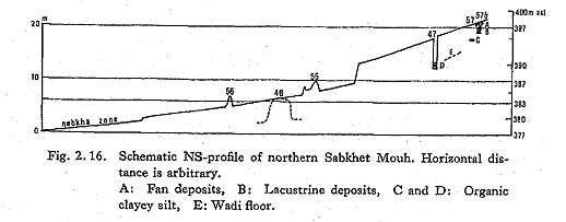
Another topographic discontinuity is also recognized at 383 m above sea level. In particular, this discontinuity is clearly recognized in the Islets area.
The formation of the lake was caused by the increase of precipitation in
the Palmyra Basin. The terraces in this basin are divided into three groups,
upper, middle, and lower. However, this division and the correlation of the
terraces are only tentative. The upper group includes the terraces correlated
with the 397 m and 387 m lacustrine terraces. The middle terraces include
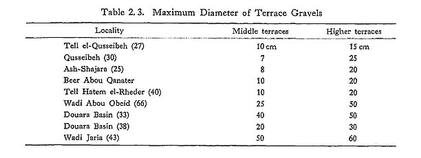
the terraces correlated with the 383 m lacustrine terraces. As shown in Table
2. 3, the grain size of the upper terrace deposits is larger than that of
the middle ones. This fact shows that fluvial action was stronger in the upper
terrace formation period than in the middle one. Fluvial actions are a function
of discharge, which depends on precipitation in a drainage basin. Therefore,
the precipitation in the Palmyra Basin is estimated to have decreased from
the period of the 397 m and 387 m terraces towards the period of the 383 m
terrace. The decline of the lake was caused by the decrease in precipitation,
not by the increase in evaporation as a result of the rise of temperature.
The period of the high water level coincides exactly with the Würm glacial
age. It is concluded that the precipitation of this period was brought about
in the summer by the polar front, which shifted southward (Suzuki, 1972).
The precipita tion was more abundant than today. As it is inferred to have
been cooler in this period than it is today in the Damascus Basin and the
Ghab depression, the same tendency is also expected in the Palmyra Basin.
The ground in the Palmyra Basin may have been more densely covered with vegetation
than at present, because of summer rainfall. The bulky hearth ash containing
Middle Paleolithic artifacts found in Douara Cave in 1974 is considered as
evidence that plant population in the Palmyra Basin was sufficient for fuel
or food for wild animals all the year round during this period. One of the
radiocarbon dates of this ash is dated more than 52,000 y.B.P. (GrN-7599).
This date is favorable to the above-mentioned inference that the pluvial lake
may have been born before 45,000 y.B.P.
Since 19,000 y.B.P. the polar front may have shifted northward, and thus
not brought much rainfall to the Palmyra Basin. Consequently, the water level
of the lake became lower discontinuously. The river mouths south of Palmyra
ceased their extension during this time. In the Ghab pollen diagram, a high
percentage of non-arboreal pollen is recognized 1.5 to 2.0 m deep, dated 16,000
to 14,000 y.B.P. The time of this zone is inferred to have been dry. As desiccation
from 16,000 to 14,000 y.B.P. is commonly recognized in the whole of the Near
East, Paleo-Palmyra Lake is inferred to have lowered its water level very
much or completely dried up. At Tabun und M. Wadi, Palestine, the Dama (moist)
/ Gazella (dry) ratio decreases from the excavation level of Wad D to that
of Wad B (Garrod and Bate, 1937). Therefore, in Palestine the desiccation
proceeded from the middle stage of the Upper Paleolithic. In the Dead Sea
region the climate is also inferred to have rapidly become drier from 20,000
y.B.P. (Fig. 2. 17; Farrand, 1971). The desiccation from 19,000 y.B.P. in
the Palmyra Basin coincides with these circumstances.

The calcium carbonate crust seen around Locality 52 is commonly formed every where from Locality 65 near Efqa Spring (Palmyra Hammam) to Locality 72 along the foot of the Southern Palmyra Mountains, and it consists of limestone and calcareous rocks. W. J. van Liere (1960/61) has concluded that the calcium carbonate crust in Palmyra was formed in the early Quaternary, because there is not sufficient calcium in the solution to precipitate with a rainfall of less than 200 mm. At Locality 72, the terrace surfaces and the upper part of their slopes are covered by a calcium carbonate crust 50 cm thick. Therefore, the formation of the crust took place after the formation of the terraces. Moreover, the crust around Palmyra includes Epi-Paleolithic artifacts. On the other hand, the surface soils bearing the Kebaran and the Geometric Kebaran artifacts at Locality 50 are not encrusted. However, the stratigraphical rela tionship between the well and the archeologic sites around the well at Locality 50 is not sufficiently clear. According to the Ghab pollen diagram, it is inferred to have been somewhat moister in the period between 10,000 and 8,000 y.B.P. This period seems to be suitable for the formation of a crust. Though we have not yet found artifacts more recent than Epi-Paleolithic in the crusts near Palmyra and cannot confirm the strict time of the crust formation, it is certain that the crust was formed at a time between the Epi-Paleolithic and the Pre-Pottery Neolithic.
The crust may have been formed in the following manner: rain water, deeply in filtrated into the ground, rises again up to the ground surface by capillary action and evapotranspiration, and calcium carbonate precipitates in the interstice of the soil. A climate in which rain mainly falls in the hot season is suitable for this process. Accordingly, the rainy season of this time in the Palmyra Basin was the summer. The temperature of the summer half year is implied to have been as high as at present. Sabkhet Mouh may have been filled with water. Its maximum level is considered to have been no more than about 383 m above sea level.
At the ruin of Palmyra many columns have been abraded at the bottom by sand blasting so completely that their flutings have disappeared. Judging from this fact, it is concluded that the climate was dominantly dry since the third or the sixth century, when the city wall around the ruin was destroyed. A minor topographic discontinuity is recognized at about 379 m above sea level. This level coincides with the upper limit of the nebkha zone. This knick point may have been formed at the highest water level of the playa lakes. The giant nebkhas are said to have been formed during the last few decades. The nebkha zone is certainly extending. The sand dune at Locality 54 is actively climbing up the mountain slope. The diminishing of the playa lake area suggests a decrease in rainfall. It is said that the Syrian Desert supported large herds of gazelle and Syrian wild ass (Equns hemionus) as recently as 200 years ago (Schroeder, 1970). Tamarix which formerly grew in Sabkhet Mouh was felled for use as material for fuel and dwelling. The desertification around Palmyra is considered to have been brought about not only by climatic fluctuations, but also by man's impact on the vegetation.
Acknowledgement
The author wishes to thank Dr. W. van Zeist, Institute for Biological Archaeology, University of Groningen for making palynological studies, and Prof, H. Kobayashi, Tokyo Gakugei University for making a diatom analysis.
LITERATURE CITED
- Farrand, W. R. (1971)
- Late Quaternary Paleoclimates of the Eastern Mediterranean Area. In: Turekian, K. K. (ed.), The Late Cenozoic Glacial Ages. xii+606pp., Yale Univ. Press, New Haven, 529-564.
- Garrod, D. A. E. and Bate, D. M. A. (1937)
- The Stone Age of Mount Carmel, I. 240 pp., Oxford at the Claredon Press.
- Kaiser, K., Kempf, E. K., Leroi-Gourhan, Arl., und Schütt, H.(1973)
- Quartärstratigraphische Untersuchungen aus dem Damaskus-Becken und seiner Umgebung. Z. Geomorph. N. F., 17: 263-353.
- Kendall, R. L. (1969)
- An Ecological History of the Lake Victoria Basin. Ecol. Monogr., 39: 121-176.
- van Liere, W. J. (1960-61)
- Observations on the Quaternary of Syria. Berichten Rijksd. Oudheidk. Bodemonderzoek, 10-11: 7-69.
- Neal, J. T. and Motts, W. S. (1967)
- Recent Geomorphic Changes in Playas of Western United States. J. Geol., 75: 511-525.
- Niklewski, J. and van Zeist, W. (1970)
- A Late Quaternary Pollen Diagram from North western Syria. Act. Bot. Neerl., 19: 737-754.
- Ponikarov, V. P. (ed.) (1967)
- The Geology of Syria. Explanatory Notes on the Geological Map of Syria, I. Ministry of Industry, Syrian Arab Republic, 229 pp.
- Schroeder, H. B. (1970)
- The Paleolithic Industries from the Syrian Desert Cave of Jerf Ajla. Etudes sur le Quaternaire dans le Monde, 2: 1017-1024.
- Suzuki, Hideo (1972)
- World Climates of the Würm Glacial Age. The Quaternary Research, 11: 171-180.
- Suzuki, Hisashi and Takai, F. (eds.) (1973)
- The Paleolithic Site at Douara Cave. Univ. Museum, Univ. Tokyo, Bull. 5: 1-150.
- Wirth, E. (1971)
- Syrien. xx+530pp.+16, Wissenschaftliche Buchgesellschaft, Darmstadt.