CHAPTER II INVESTIGATION OF THE DOUARA CAVE SITE, 1970 SEASON
Takeru AKAZAWA*, Hisao BABA** and Kunihiko ENDO***
* Department of Anthropology and Prehistory, The University Museum, The University of Tokyo
** Department of Anatomy, School of Medicine, Chiba University
*** Department of Geography, Faculty of Science, The University of Tokyo
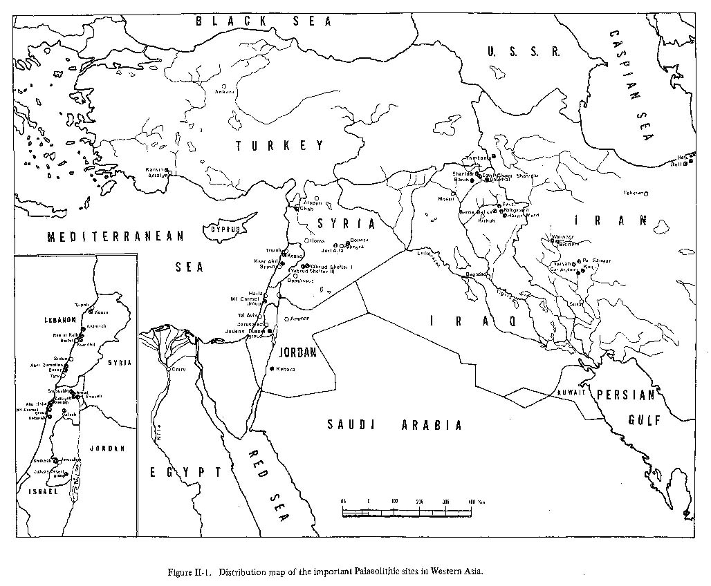
1. HISTORY OF THE RESEARCH AND THE REASON FOR SELECTION OF THE SITEThe site of Mugharet ed Douara I (referred to here as the Douara Cave Site) was found during the third season of the Tokyo University Scientific Expedition to Western Asia in 1967, and was recorded for the first time in the report of that expedition published in 1970 (Suzuki and Kobori, 1970:36). In 1967, for the purpose of finding new cave sites of Middle Palaeolithic age, the third season's expedition worked mainly in Lebanon, Syria and Jordan in western Asia. Intensive research was carried out especially in the Palmyra area in the central part of Syria for the following reasons. Up to now, most studies of Palaeolithic culture and Neanderthal man in Western Asia have concentrated in the areas of the Mediterranean coast and the Jordan Valley in the Levant, and in the Zagros area (Fig.II-1). In the former areas, dozens of Palaeolithic sites have been investigated and a large quantity of information has accumulated, and in the latter areas there are some Palaeolithic sites such as Zarzi and Hazar Merd reported by Garrod (1930) and Shanidar Cave excavated and reported by Solecki (1952, 1953, 1955a, b, 1960,1971). But research on the sites in inland areas is rather insufficient, and only two Palaeolithic sites, Yabrud (Rust, 1950; Solecki and Solecki, 1966) and Jerf Ajla (Coon, 1957; Schroeder, 1966, 1969), are fully reported. Thus there is a regional difference in the quantity of information available, and this presents an obstacle to systematic interpretation of Paleolithic culture and Neanderthal man in Western Asia. In comparing the data from the Zagros with that from the Levant, more comprehensive and interesting studies would be possible if we had more information from the Syrian inland which lies between these two areas.
The area thought to contain Palaeolithic cave sites is very restricted in the inland parts of Syria, and among these areas, the most favorable regions are the mountain masses which lie north of Palmyra (Fig.II-3). In the 1967 season we surveyed most of these mountain masses (such as Jebel Mqeitaa, Jebel el Abiad, Jebel es Safra, Dahr Rouaissafe Abou Fares, Jebel ed Douara) and as a result we found and reported 46 new sites including open air sites (Suzuki and Kobori, 1970:36-45).Most of the 46 sites had deposits thought to correspond to the Post-Palaeolithic or probably to the older part of the Pre-ceramic Neolithic, based on typological and technological analysis of the flint materials found in each site (Suzuki and Kobori, 1970:49-51; Suzuki and Akazawa, 1971). The only cave site in which we found flint implements clearly belonging to the Middle Palaeolithic was Mugharet ed Douara I (site No. 34 in Suzuki and Kobori, 1970).
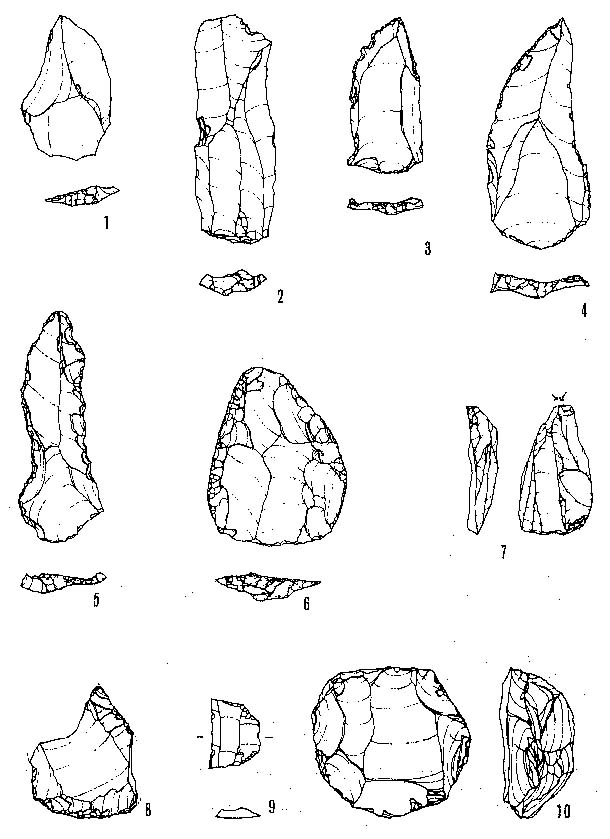
Most of the flint implements collected at Douara Cave were blade elements belonging to the Post-Palaeolithic (Suzuki and Akazawa, 1971), but mixed with them we found a small number of typical Levallois flakes, blades and points, and side-scrapers and denticulates made on Levallois flake or blade blanks, and a discoidal core (Fig. II-2). Such implements are characteristic of the Middle Palaeolithic industries in Western Asia. It has been pointed out that in Western Asia tool-making techniques of the Middle Palaeolithic survived into the Post-Palaeolithic and sometimes into the Neolithic (van Liere and H. de Contenson, 1963:177), and in Douara Cave,the above-mentioned Middle Palaeolithic-like stone implements were found with Post-Palaeolithic stone implements. However, these were easily distinguishable from each other typologically and technologically and by their degree of patina tion or abrasion. Thus it is suggested that these Middle Palaeolithic-like stone implements are true Middle Palaeolithic implements which have been removed from underlying Middle Palaeolithic deposits by certain disturbances.
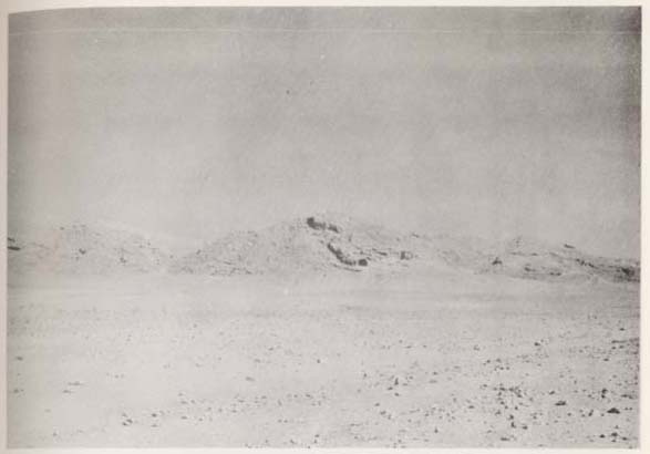
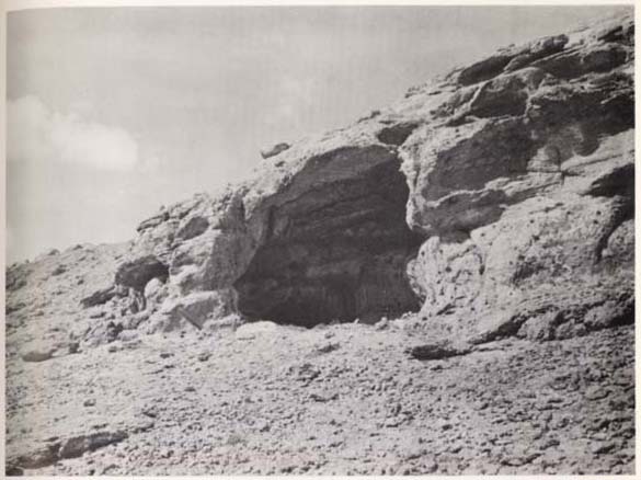
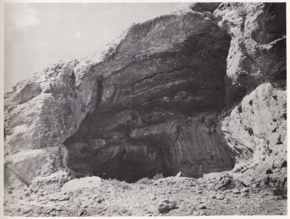
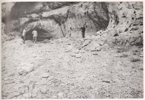
Among the flint artifacts found in the site, there also were well-made specimens such as gravers, end-scrapers, and geometric microliths which correspond, typologically and technological ly, neither to the Middle Palaeolithic nor to the Post-Palaeolithic, but probably to the Upper Palaeolithic (Fig. II-2). (The exact dating of these specimens had been kept pending until the 1970 excavation, partly because of an insufficient number of specimens). Because the 1967 season's expedition found flint tools which corresponded to the Middle Palaeolithic, the Post-Palaeolithic, and probably also to the Upper Palaeolithic only at Douara Cave, this cave was selected as the only site available for the research purpose of our 1970 expedition. 2. LOCATION OF THE SITEThe site is located in the north Syrian desert approximately 18 kilometers northeast of the town of Palmyra (Fig. II-3). In the practical terms of actual driving, the distance is 25 kilometers from Palmyra (and about 1 hour driving time). Turning left at Tell el Mounsef along the Palmyra-Arak desert road, we may easily find the large cave on the southern slope of Jebel ed Douara (Pls. II-1, 2).
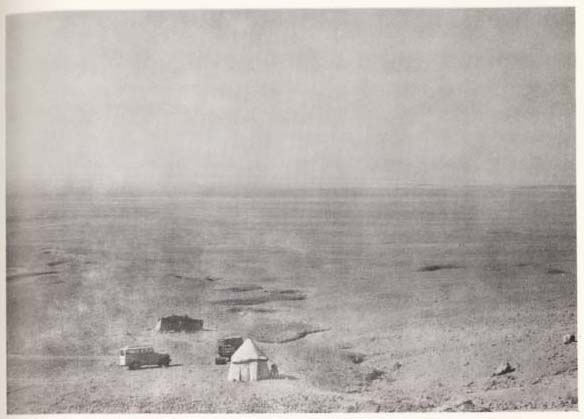
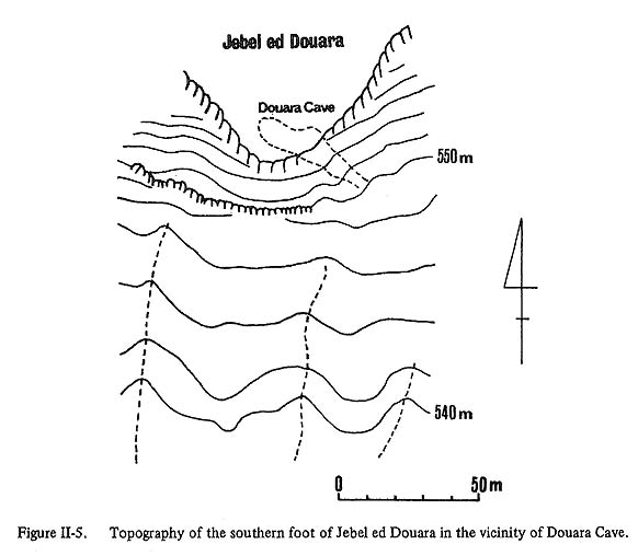
Jebel ed Douara is one of the mountains made of Paleogene limestone (Ponikarov et al., 1966), bordering the northern margin of the Palmyra Basin located in the central part of Syria. On the southern foot of the mountain many fans are formed, and they slope down slowly toward a central marsh, the Sabha, in the Palmyra Basin (Pl. II-3a). The altitude of the cave is about 557 meters above sea level, about 170 meters above the plain of Sabha and about 15 meters from the top of the younger fan.
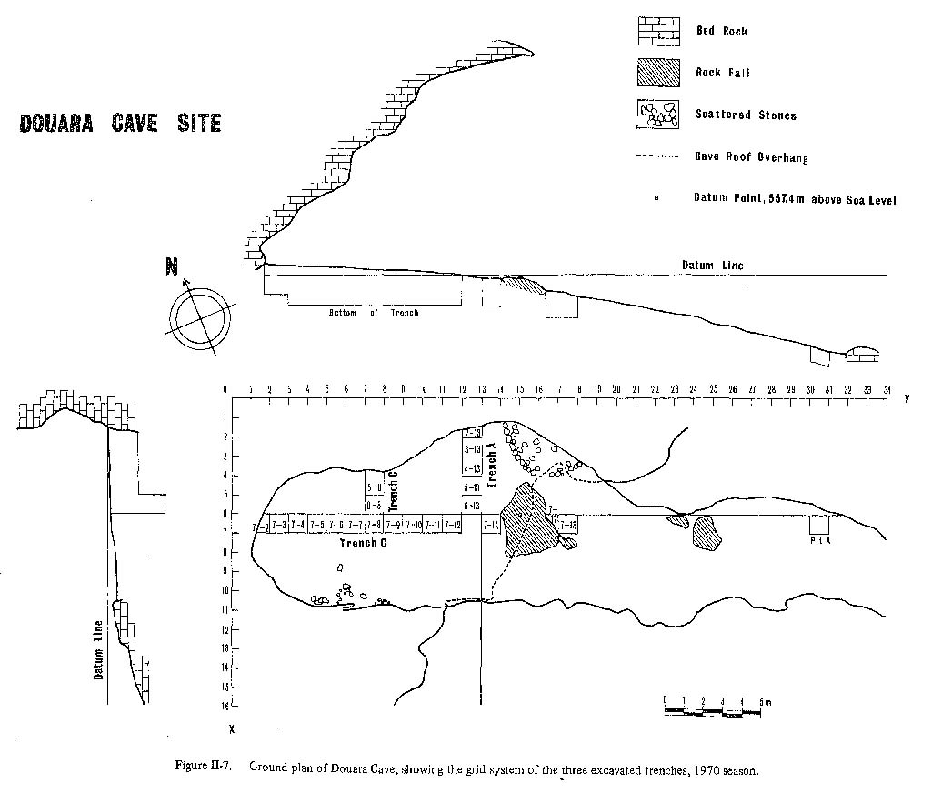
The Palmyra Basin is oval-shaped and its long axis is oriented approximately east-west. It is several tens of kilometers long. According to the UNESCO-FAO (1963) bioclimatic map, the Palmyra Basin lies in the border area between desert and sub-desert. Annual precipitation in the western part of the basin is about 100 mm and occurs only in winter. The landscape in the basin is characterized by widely scattered dwarf shrubs such as Chenopodiaceae, Artemisia, and Compositeae. These shrubs are quite scarce except in the areas along the wadi and the margin of Sabha. This means that the Douara Cave is located in one of the most arid regions of any excavated Middle Palaeolithic site. 3. MORPHOLOGY OF THE SITEThe Douara cave is about 10m wide at the entrance and about 14 m deep, with a roof some 12 m high at the center of the opening (Figs. II-4~7). The roof slopes down to the rear of the cave. The axis of the cave is oriented NW-SE, and the cave mouth opens to the southeast. There is a large fallen rock (3.15 m × 2.8 m) in the center of the floor at the opening. The earth floor of the cave is very flat. It was probably levelled artificially by Bedouin who seasonally visit the cave with their herds of goat and sheep.
Flowstone covers the entire cave wall (Pl. II-3b). At several places traces of water flowing from joints and fissures can be seen by the thick accumulation of flowstone on the wall. Flowstone also is formed on the ceiling except just inside the edge of the roof from where a large rock fall probably occurred.
A great number of joints, small faults and fissures were found in the limestone around the cave (Pls. II-2b, 3b). These are vertical, tending to be mainly E-W although some are NW-SE. The most impressive feature of the site is the long, narrow terrace in front of the cave (Figs. II-4~7, Pl. II-4a). This terrace is 1.5 to 6 m wide, about 8 m high and more than 30m long. Its long axis coincides with that of the cave. It is surrounded by a platform of limestone bedrock on both sides, and its surface is about 30 cm lower than this platform. The terrace looks like a corridor leading to the cave. There is a talus-like slope of coarse limestone debris below this corridor-shaped terrace, which extends downwards toward a wadi fan (younger fan) (Pl. II-3a). This slope is about 5 to 10 m high and 20 to 30 m long.
The limestone bedrock around the cave runs E-W and dips 10° to 30° to the south. The limestone consists of the alternation of hard limestone and fragile, marly limestone. The hard limestone is quite resistant to weathering and erosion, and the bedding plane of the resistant bed tends to be exposed by erosion of the marly limestone. The limestone platform surrounding the corridor-shaped terrace shows the approximate bedding plane. 4. EXCAVATION PLAN AND STRATIGRAPHY OF THE DEPOSITS1) Excavation PlanThe 1970 season's research was only a preliminary excavation to learn the general conditions of the deposits inside and outside of the cave and to examine the horizontal and vertical distribution of the Middle, Upper, and Post-Palaeolithic deposits whose existence was suggested by the flint materials collected during the 1967 survey. The main excavation will be made in the near future. The floor of the cave itself is flat and slightly inclined toward the entrance. Its surface is entirely covered with a felt-like layer about 1 to 4 cm thick, composed of goat and sheep feces and fine materials. This black to dark brown colored layer was entirely removed from the cave prior to excavation. The method of excavation was by a grid system of 1 ×1 meter units. A total of 22 units were sounded in the 1970 season (Fig. II-7, Pl. II-4b). The excavation was carried out in trenches designated A, B and C.
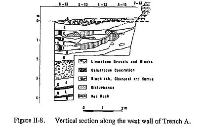
Trench A was composed of 5 units (2-13, 3-13, 4-13, 5-13, 6-13) and was nearly parallel to the cave mouth (Fig. II-8). We hoped to gain an outline of the stratigraphy and cultural sequence of the site, but we could not achieve all the expected results because of marked disturbances probably caused by the activity of animals.
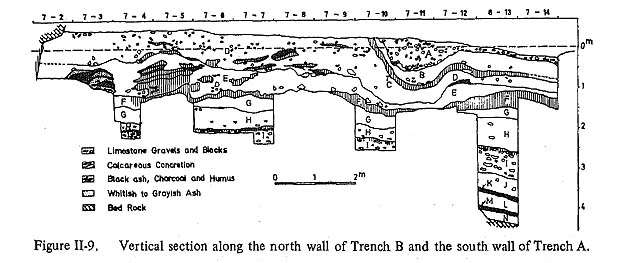
Next, Trench B was set at a right angle to Trench A and parallel to the long axis of the cave (Fig. II-9). This trench was composed of 11 units (7-2, 7-3, 7-4, 7-5, 7-6, 7-7, 7-8, 7-9, 7-10, 7-11, 7-12) plus 4 extension units (7-14, 7-17, 7-18, 7-31) outside the cave. Trench B was set in order to observe the distribution and thickness of deposits along the long axis of the cave, with extension units intended to clarify the relationship between the deposits inside the cave and those in the terrace.
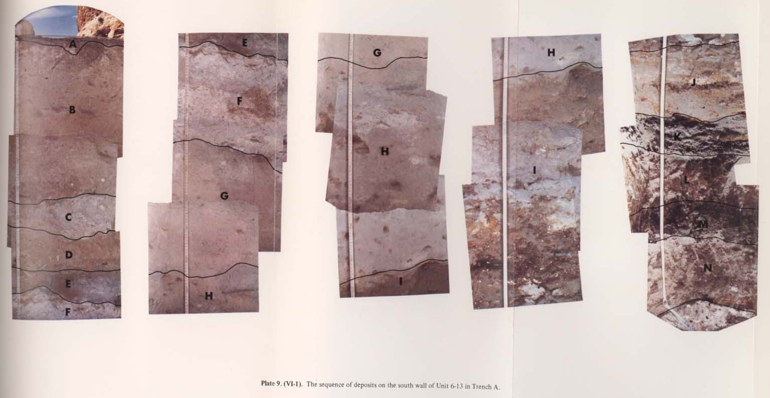
Lastly Trench C, composed of two units (5-8, 6-8), was set parallel to Trench A and at a right angle to Trench B. The purpose of Trench C was to get more information about the condition of the deposits along the transverse axis of the cave because the information from Trench A was not clear. From the total excavation of the three trenches, it was found that the sequence of deposits could be divided into 14 geological layers (designated from the top as Layers A through N) by the differences in color and texture of the deposits (Pl. VI-1). Each layer has a specific color, texture and other characteristic features which do not vary throughout the excavated areas except in a few layers, and the boundaries of adjoining layers are sharp except for deposits near the cave wall. Well consolidated, grayish to grayish white calcareous concretions are found to a width of 10 to 100 cm from the cave wall, and only here the boundaries between layers are obscure.
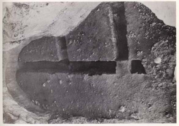
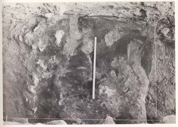
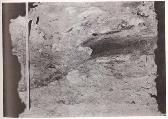
Trench A was first excavated from the surface to Layer H or I, about1.7 m in depth, and then from Layers J to N in Unit 6-13, where excavation reached hard limestone rock at some 4.3 m below the surface. The sequence of 14 layers was entirely clarified only in Unit 6-13 of Trench A. Trench B was first excavated to the top of Layer F, about 1.5 m in depth in general, and then to the upper part of Layer I, about one more meter deep, in Units 7-14,7-6,7-7 and 7-10. Trench C was excavated to the top of Layer F, about 1.3 m in depth. 2) Description of Each Layer.LAYER A: The distribution of Layer A is restricted to the area including all units of Trench A and Units 7-14 to 7-10 of Trench B. It is absent in the interior of the cave inward from Unit 7-9 of Trench B. The thickness ranges generally from 5 to 30 cm, having a maximum thickness of about 85 cm in Unit 7-11 of Trench B. This layer is a loose, porous, yellowish gray to brown sediment, composed of silty sand and a large amount of angular limestone rubble. The rubble is mainly pebble to cobble in size, with a few pieces of boulder size. It contains numerous flint implements and animal bones. LAYER B: The distribution of Layer B is about the same as that of Layer A in the excavated area. It varies from 5 to 45 cm in thickness, averaging about 30 cm. This layer is a loose, dusty, light brown sediment, composed mainly of fine sand and silt with a small amount of limestone debris. Like Layer A, it is rich in flint implements and animal bones. LAYER C: This layer occupies about the same area as Layers A and B. It is a massive, calcareous concretion layer which thinly covers the slope and bottom of a depression which is thought to have been formed by erosion of the underlying layer. It is 5 to 30 cm thick, compact, whitish gray to grayish brown in color, and composed mainly of silty, sand-size material. It includes abundant flint implements and animal bones. Almost all the flint implements are broken and discolored and bear adhesions of the calcareous concretion. LAYER D: This layer is distributed throughout the excavated areas. It varies from 15 to 100 cm in thickness. Inward from Unit 7-10 it is 60 to 100 cm thick, but toward the entrance from Unit 7-10 it is only 20 to 35 cm thick. The upper horizon of Layer D is truncated by Layer C outward from Unit 7-10. As a whole it is abrown colored deposit, constituted of fine material, containing fine sand grains as its principal component. A large number of thin lenses of black to dark brown humus, black charcoal and a whitish calcareous concretion are intercalated, especially in the lower half of this layer. In the outer half of the excavated area, a thin black to dark brown band, an admixture of organic matter, runs almost continuously at the bottom of the layer. In the inner half of the excavated area, limestone debris appears relatively more frequently than in the outer half. This layer includes a great number of flint implements and animal bones. LAYER E: This layer is distributed throughout the excavated areas. Its thickness is 45 to 100 cm in the inner units, but it decreases to 10 to 45 cm near the cave entrance. The top surface of the layer is undulating. These features suggest that the upper part of Layer E is truncated by Layer D near the cave entrance. In general this layer is a grayish to grayish brown sediment, composed mainly of fine sand and silt-size materials. It is slightly more compact as compared with the overlying layers. It contains very little limestone debris. In the units near the entrance, it is a gray to dark gray color, comparatively homogeneous and rich in fine organic material. Stratification is not clear. On the other hand, in the inner half of Trench B, Layer E is not uniform and is gray to grayish brown in color. It contains numerous intercalations of black charcoal and humus, a grayish calcareous concretion and grayish ash. Especially in Unit 7-5, it has a series of such intercalations about 80 cm thick. Stratification within the layer is readily distinguishable. In Unit 7-3, near the interior end of the cave, an alternation of lenses of grayish ash and black charcoal was found (Pl. II-5). This alternation is about 50 cm thick and more than 1 m wide. Bordering the interior margin of this alternation, reddishyellow stones are arranged across the trench. A great number of flint implements and animal bones is included throughout this layer.
LAYER F: This layer is distributed throughout the excavated areas. It is 10 to 40 cm thick in general, attaining a maximum thickness of 50 cm just inside the cave entrance. It is a massive and uniform, whitish calcareous concretion layer, cemented tightly and composed of silty sand and a small amount of limestone debris. The top surface of this layer is comparatively undulating. The upper and lower boundaries of this layer are very clear. In Units 7-6 and 7-7, a channel-like depression crosses Trench B. Layer F seems to be continuous along the tightly cemented sidewall of the depression which was dug 50 cm into Layers G and H. The agency forming this channel-like depression was probably eroding water. This layer contains a small number of flint implements and animal bones. LAYER G: This layer is probably distributed throughout the excavated areas. It is 10 to 45 cm thick. It is a comparatively loose, pinkish colored sediment, composed mainly of fine sand and silt-size materials. It is the finest grained of all the layers. It contains very little limestone rubble. The sedimentary facies of this layer is massive and homogeneous, and stratification is invisible. Flint implements and animal bones are rare. LAYER H: This layer seems to be distributed throughout the excavated areas varying from 20 to 80 cm in thickness. It is a brown to grayish brown colored, sticky sediment, composed mainly of silty sand-size material. It is compact compared with Layer G and partially includes intercalations of a whitish calcareous concretion and limestone rubble. The boundary between Layer H and overlying Layer G is transitional in places. The layer contains only a few flint implements but a fair number of animal bones. LAYER I: This layer seems to be distributed throughout the excavated areas though it was observed only in the deeper pits of the trenches. In the vicinity of the cave entrance, it is 65 to 90 cm thick. In Units 7-4, 7-6, 7-7 and 7-10, only the upper part of the layer was excavated, and its thickness is not clear. It is a yellowish brown sediment and includes a great amount of angular limestone rubble as its principal component. It is more compact and sticky than the overlying layers. The matrix of the layer is composed of silty sand-size material. The limestone rubble ranges from pebble to boulder size, but is mainly cobble size. The uppermost horizon of this layer is characterized by tightly cemented calcareous concretions containing a lot of limestone debris and animal bones. In general this layer contains a considerable amount of animal bones but only a few flint implements. LAYERS J, K, L, M and N: Layers J through N were excavated and recognized only in Unit 6-13 of Trench A, and the distribution of these layers is not known. These layers are particularly compact and difficult to excavate without a hammer. They are very highly and deeply colored yellowish brown to reddish brown, except Layers K and M which are black to dark brown in color. These features suggest a soil formation process spanning a long time. These layers are inclined gently outward. In Unit 6-13 these layers appear to be unaffected by human activity- they lack flint implements and other artifactual materials. Layer J is 30 to 45 cm thick and yellowish brown to orange, shading to reddish in color. It is composed mainly of silty sand with a small amount of limestone rubble. It is exceedingly sticky on the whole. It is intercalated with thin yellowish brown beds containing limestone debris and shows slight stratification. Layer K is 12 to 15 cm in thickness. It is subdivided into three horizons, K-1 the upper-most, K-2 and K-3. K-1 is a black humus soil, 5 to 6 cm in thickness. K-2 is a very compact, brown soil, 2 to 3 cm thick. K-3 is a dark brown to black humus soil, 5 to 9 cm thick. These soils are composed mainly of silty sand with a small amount of limestone debris of granule to pebble size. K-l and K-3 are characterized by vast accumulations of humus. Layer L is very compact and brown to reddish brown in color. It is composed of silty, coarse-grained sand. It is 20 to 30 cm in thickness. Most of the sand grains are coated with fine-grained materials. Limestone debris is scarce. Layer M is composed mainly of silty humic sand and is dark brown to black in color. It is 10 to 20 cm thick and is thought to be a soil formed by the accumulation of humus. Layer N is brown to reddish brown in color. It is very hard and compact. Coarse sand grains are its main component, and the spaces between the grains are filled with fine materials. It is 20 to 40 cm thick. Weathered limestone was exposed at the base of this layer. This limestone is more than 10 cm in thickness, and is very hard and yellowish brown in color. It must be kept pending until future excavation whether or not this limestone is the original floor of the cave. 5. PALAEOLITHIC ASSEMBLAGES FROM THE DOUARA CAVEDuring the 1970 season, we found about 3,500 objects classifiable as artifacts from throughout the excavated areas. The sequence of deposits was divided into 14 geological layers, as described in the preceding section. However, the layers producing human artifacts are limited to the upper nine layers, Layers A through I. The relative quantity of the flint artifacts varies considerably in each layer. Layers A through E have the richest archaeological deposits, yielding a large quantity of artifacts, while the underlying Layers F through I have poor archaeological deposits, even if consideration is given to the relatively small areas excavated in these layers. Analysis of these flint artifacts showed that the deposits of Douara Cave contain two distinct assemblages: an assemblage with a large proportion of blade and bladelet elements of Upper Palaeolithic character found in Layers A and B, and an assemblage with a large proportion of Levallois flakes found in Layers C, D and E. The assemblages in Layers A and B have the same characteristics, both typologically and technologically, as the Kebaran industry from Layer C at the type site of Mugharet el Kebarah (Turville-Petre, 1932), the Nebekian industry from Layers 7,6 and 4 at the type site of Yabrud Shelter III (Rust, 1950), and the Zarzian industry from the type site of Zarzi (Garrod, 1940). These industries all are now well-defined both typologically and stratigraphically as the terminal stage of the Upper Palaeolithic in Western Asia (Howell, 1959; Copeland and Waechter, 1968). These industries are also classified into Stage 6 in Neuville's nomenclature for Upper Palaeolithic industries in Western Asia (Neuville, 1951). The assemblages in Layers C, D and E resemble closely the industry that is identified as the Levalloiso-Mousterian or the Mousterian of Levallois facies of the Middle Palaeolithic in Western Asia. These assemblages are characterized by the dominance of the Levallois technique in the production of tool blanks and by Middle Palaeolithic tools of the Levallois type and the Mousterian type tools such as a side-scraper. Layers F through I yielded very few flint implements with characteristics of Middle Palaeolithic tool types. However, these artifacts are too scarce to identify these horizons to certain industries already defined. This awaits further excavation of the site.
BIBLIOGRAPHY
|