CHAPTER I EXCAVATIONS
|
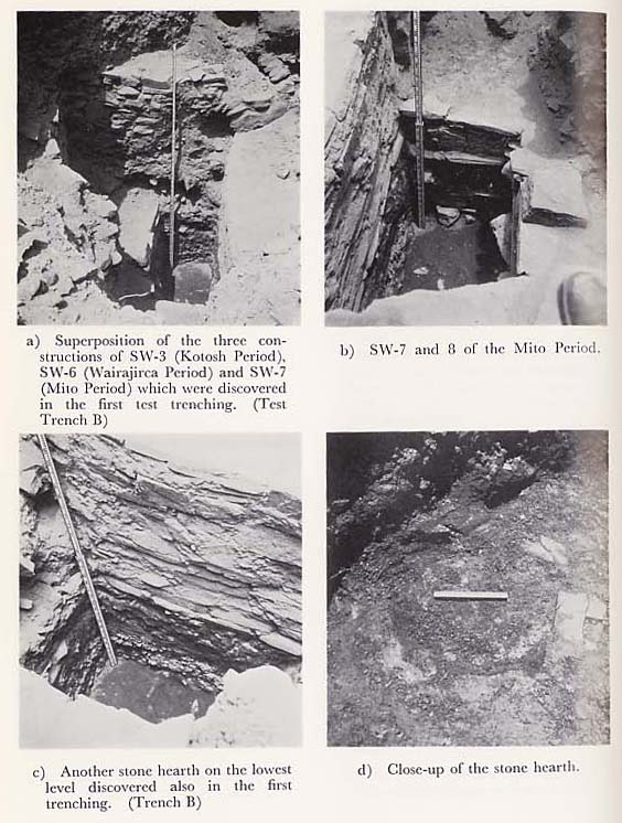
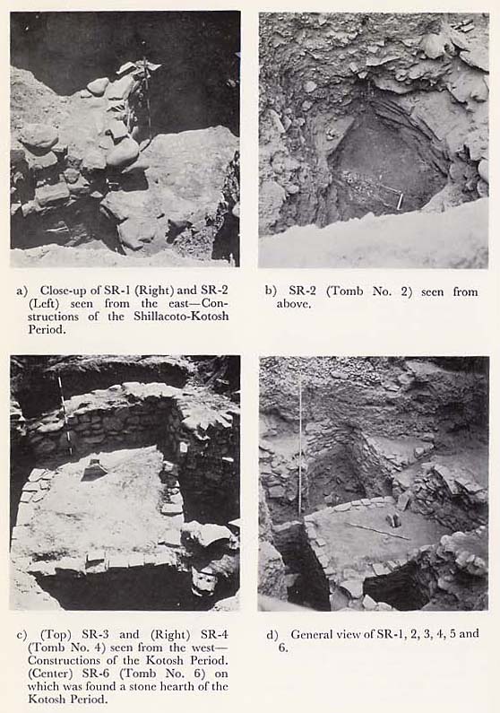
As stated before, this site is now situated within privately owned land. The area that can be confirmed as the archaeological site extends over 100 m. from east to west and 80 m. from south to north ; on the level portion of the land on the south-eastern side of the area stands the house of the owner. On the northern side, a wall made of piled up stones has been built to constitute a boundary with the neighbor. This is situated at the highest level within the site. On the eastern part, an adobe wall surrounding the private land has been constructed. On the outside of this wall, there is a narrow road running parallel to it. Because of a recent housing area construction project in this area, the entire site on the eastern side, except for this road, has been completely dug up, with a portion of the ancient structures being exposed on its cliff-like section. The western part is covered with bushes of cactus, maguey and other shrubs and it is presumed that this area also contains some archaeological relics. The further western part from this area covered with shrubs has been destroyed and turned into farm land. This area forms a steep cliff. Under such circumstances, it is difficult to estimate the exact scale of this site. However, assuming that the northern part-the highest spot in the site-was its center, it can be estimated that the site was presumably a mound covering an area of at least 200 m. square and about 15 m. high. Prc-excavation observations had revealed that this site had very few trees except in the bushy area mentioned above, and that the entire area was covered with gray-brown soil, pebbles and boulders scattered all about. There were also. traces of the site having been excavated many times previous to official excavations, with large depressions of holes everywhere. The site thus appeared completely devastated. In carrying out our excavation, three trenches-A, B, and C-were first dug to obtain general information on stratigraphy within the site. Of these trenches, A and B were provided beside the boundary wall with the neighbor on the northern side. They were each about 3 m. wide and 10 m. long, with a distance of 3 m. between them. Trench C, provided to the west of the center of the mound near the bush, was 3 m. wide and 5 m. long. It was found that Trench A partially duplicated the one made by the Tokyo University team in 1966 and therefore its, excavation was interrupted for a while. The stratum of Trench C, as it was dug about 3 m. deep, was found largely disturbed, making it difficult to study its condition. Excavation of this trench, too, was therefore suspended and, as a result, Trench B was mainly used for our survey. In Trench B, small pebbles and rock fragments were packed tightly under thin surface soil. This layer was 1.5 m. to 2 m. thick at the northern boundary but was thinner on the southern side, where it was 50 to 60 cm. The earth in which the small pebbles were buried was dry, red-brown earth, which contained ash and charcoal, and a small quantity of potsherds of the Higueras Period was discovered there. About 2 m. south of the northern wall of the trench and immediately below the pebble layer, a tomb of the Higueras Period was uncovered at a depth of about 1.5 m. This tomb (Tomb No. 1) had a stone cist made of several flat pieces of micaschist, but it was considerably damaged, only about half of it having retained its original form. Its stone lid could not be found. The tomb measured about 70 cm.× 80 cm. × 45 cm. and was filled with red-brown earth. Near the bottom of the stone cist, tiny pieces of a skull, a few potsherds of the Hligueras Period and two copper needles were discovered (PL. 19-.C). On the eastern side of the center of the trench, there was no layer of pebbles in the topsoil. The black-brown soil was soft and its stratum had been disturbed. Potsherds belonging to various periods were discovered there. This part of the site presumably had been excavated previously. The earth under the pebbles layer had generally turned into yellow-brown, sandy earth containing ash. Further below was red-brown earth containing charcoal grains and lumps of burned earth. In the north of the trench, a hard level surface, which presumably was a floor, was recognized at a depth of about 1 m. from the topsoil. This hard, floor-like surface extended to the central part of the trench but did not go as far as the southern side. The wall of the construction, which should correspond to the floor, was not discovered. Below the floor was a 30 cm. thick layer of red-brown earth containing ash and small fragments of rocks, and further below, another floor was uncovered. Like the upper floor, the lower one also had not. been preserved in recognizable form on the southern side and only a hard level surface was to be found here and there in the red-brown and gray-brown soil layers. Foundation stones for the wall were not found either, some crushed slabs, which appeared to have been used as wall stones, were scattered here and there. From the red brown stratum including this floor, mainly potsherds of the Higueras Period were unearthed. Below the red-brown earth layer, there was a deposit of a 40 to 50 cm. thick gray-brown layer containing pebbles and rock fragments. On the northern side of the trench, a stone wall appeared. To trace the extension of this wall, the northern portion of Trench B was extended east by about 3 m. × 3 m. in order to connect it with Trench A referred to before. This portion was designated as Trench B-Extension 1. The western side of the trench was also extended 3 m. &time; 3m. to facilitate earth removal. This portion of the trench was designated as Trench B-Extension 2. The wall mentioned above was made up of piles of small boulders and breccia. Its continuation was seen in the extended section and it was curved like a petal, as though to constitute a small room. Although it was .actually one wall, the wall was divided at each curved corner and designated as S-W1, 2, 3, 4, and 5, respectively. The portion surrounded by S-W1, 2, and 3, was designated as S-R1, and the area surrounded by S-W2, 4, and 5, as S-R2. S-W2 was a wall common to both rooms and had two wall surfaces.
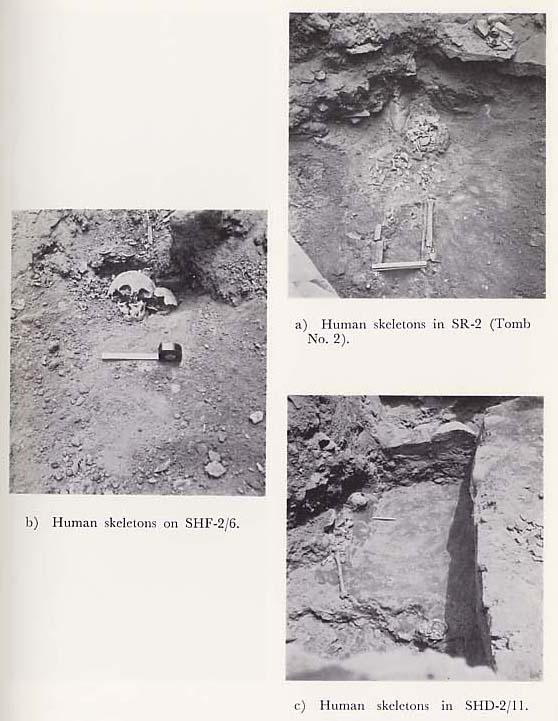
Extension zones 1 and 2 of Trench B both had a thick deposite of pebbles in the upper layer, which contained very few artifacts. The condition of the stratum under the pebble layer of Extension 1 zone was about the same as that in the northern portion of Trench B, A hard, reddish-brown floor existed over two layers, and over the upper layer floor, a 20 cm. thick ash layer spread. In there, potsherds of the Higucras Period were discovered in. large quantities. From under the second floor-from under the layer containing pebbles and crushed stones-S-W3 appeared. The stratum within Trench B in which S-R1 was buried was a brown or red-brown relatively compact layer containing a large quantity of rubble. From. the center to the south of the trench, a few layers of black ash containing charcoal existed in the form of a belt. In some parts, deposits of a very thick-50 to 60 cm.-white layer of ash were noted. This soil layer extended from S-R1 to the entire area in the south. A large number of materials were unearthed from a depth of 2 to 2.6 m. from the topsoil. The ceramic wares were mostly of the Kotosh Period but a small quantity of Wairajirca potsherds was also mixed in. In the eastern sector of Trench B, however, there were vestiges of a previous excavation over a width of about 1.5 m. and a depth of 2 m. The layer in this part had been disturbed, and soft, black soil containing tree roots had been deposited, into which heaps consisting of several large ashlars had fallen. In S-R1 the rock fragments in the reddish-brown lower layer referred to above decreased, and a level, hard clay-type floor was exposed from below a thin, gray-brown layer containing ash, charcoal and lumps of burned soil. The foundation stones of walls S-W1, 2 and 3, ended at a point about 30 cm. below the floor. From this, it was estimated that S-R1 was a part of a construction, of the Kotosh Period. The S-R2 was a small round room with a diameter of about 1 m. The man ner in which the soil was deposited differed from that in S-R1: in the upper layer, large stones, which seemed to have been fallen wall stones, were buried, mixed with crushed pieces of micaschist. The soil was relatively soft, brown earth. The lower layer was a deposit of bright brown earth which did not contain any stones, and from this layer human bones were recovered, the bones of two adults and one child (Tomb No. 2. see PL. 15-a). The skull of the adult had.disintegrated and fallen over the pelvis. It is believed that the dead were buried in a crouching position. A flat piece of micaschist, about 20 cm. × 20 cm. in size, was placed on the bones, but there were no other burial facilities such as stone cists. S-R2, itself, may have been the tomb for the dead. As the bones were picked up and the surface on which they were found was cleaned, a hard clay floor appeared. From this level, a polished stone knife was uncovered (See PL. 23-c).
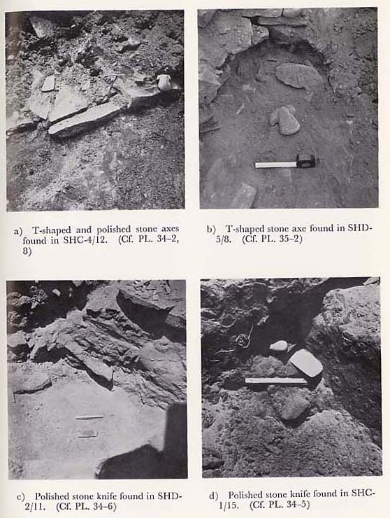
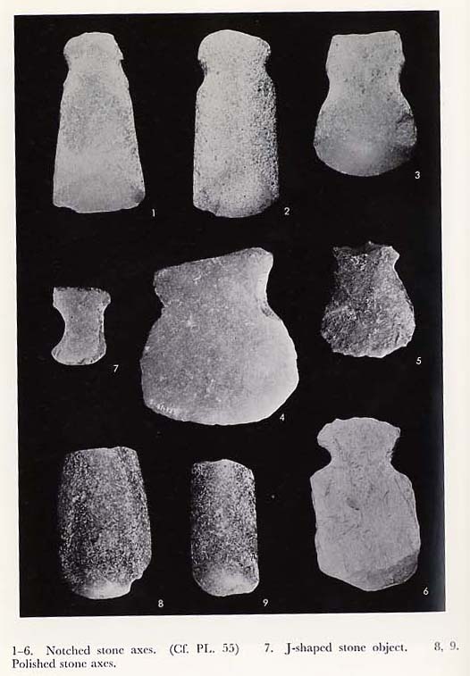
After discovery of S-R1 and 2, Trench B was dug further below. The floors of S-R1 and S-R2 were each about 30 cm. thick and their surfaces were covered with fine-grained gray-brown clay. The layer about 30 cm. below the floor of S-R1 was a soft, gray-brown layer, and from there, potsherds evidently of the Wairajirca Period became predominant. Also in the S-R1 zone, a polished stone axe (Sec PLs. 36-3, 55-2) and one ceramic accessory were uncovered. From immediately below this layer, the head portion of the wall S-W6 appeared. In Trench B and Trench B-Extension 1 zones, emphasis was placed on the excavation of the northern side of S-W6, i.e. on the investigation of stratum under the floor. Brown soil not containing too much rubble was deposited up to a depth of about 85 cm. including the above-mentioned grayish brown soil layer, and from there, only Wairajirca type potsherds were recovered. Then, there appeared a layer which contained a great quantity of rubble. The earth there was dry, coarse-grained sandy oil, gray-brown or yellow-brown in colour. In the lower parts of this. layer, the stones grew smaller in size and the quantity of objects unearthed decreased. The layer of rubble gradually changed to a black-brown soil layer, and the occurence of materials from this layer suddenly decreased. In the north of S-W6, the top surface of the wall S-W7 appeared from the point where the black-brown soil layer began. The black-brown soil layer referred to earlier had a thickness of about 50 to 60 cm. and a red clay floor could be seen below it. Be - tween S-W6 and S-W7, large stones measuring about 60 cm. by 50 cm. and thin ashlars of micaschist as well as rock fragments were packed in huge quantities. The deposit of these rocks had destroyed the red clay floor and continued further down to the lower layers. Portions of a yellow coating of fine-grained clay were found stuck here and there on these rocks and on the ashlars of micaschist. In the course of the removal of these rocks, the surface of S-W7 became exposed, running from east to west, and on the western side of S-W7, the wall S-W8 appeared, crossing S-W7 at right angles. It was quite noticeable both of these walls were of excellent structure compared with any others discovered in the trench before, having been built of neatly piled dressed stones. The section which formed the wall surface was about 55 cm. high. Thin, flat stones were used in its top and bottom, and in the central section, the dressed stones were laid longitudinally, or small ashlars were piled up laterally.
Judging from the structure of these walls and also from the fact that yellow clay coating was found in the layer, it was presumed that these walls formed part of structures resembling constructions of the Mito Period, a pre-ceramic period in the Kotosh site. However, a small quantity of ceramic wares of the Wairajirca Period were found in the above-mentioned black-brown soil containing stone lumps, and furthermore, there was a niche-like concave under the bottom of the wall. The concave was filled with black-brown earth, masses of small pebbles and rocks, from which a fragment of pottery of shallow incised type in Wairajirca Period was discovered. The niche-like concave was located about 60 cm. high and flat dressed stones were laid at the bottom, and as if to support these ashlars, square foundation stones were placed. Under the foundation stones, a fine yellow-brown clay floor spread within the trench and a stone hearth which was presumably used on the floor was also uncovered (PL. 12-c, d). The hearth was about 50 cm. in diameter and its top was pentagonal in shape, surrounded by small flat stones. Judging from its level and the location of the hearth, it was obvious that the floor with this hearth belonged to a structure which had been built before S- W7 and 8.
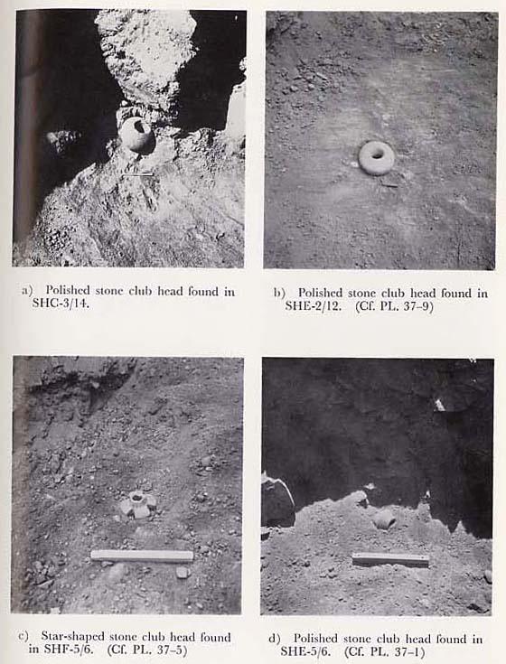
In excavations inside the narrow trench, it was impossible to grasp stratigraphical relations accurately or to clarify what portions of what building the walls S-W7 and 8 comprised. Therefore, it was decided to expand considerably the excavated section mainly centering around Trench B and to reorganize the whole excavation zone. The excavation site was thus enlarged to an area of 12 m.× 12 m. extending from east to west and from north to south. A grid-like excavation site was super-imposed by further dividing the area into smaller sections of 3 m. each, which were designated as SHA-1-SHA-4, SHB-SHB-4, SHC-1 -SHC-4, and SHD-1-SHD-4. Under this designation of various sections of the site, the original A Trench corresponded to A zone, B Trench to C zone, Trench B-Extension 1 to B-1 zone and Trench B-Extension 2 to zone D-L The following is a description of investigations following the excavations of each of these newly-established small zones. SHA Zone: In zone A, the deposit of pebbles in the upper layer was thin, while the layer below it had been disturbed to a depth of about 3 m. The soil was soft and medium sized stones, presumably crumbled wall stones, were scattered about. Ceramic sherds of various periods were found mixed with them. No walls or floors of buildings were uncovered. It was presumed that this was. one of the locations which had already been excavated. SHB Zone: In zone B-1, our excavation was started from the head portion of the wall which seemed to be a continuation of S-W3. S-W3 curved east near the boundary between B-1 and 2 zones but had crumbled at its cast end. The portion extending, to the south of S-W3 was lower since two or three wall stones in the upper part had crumbled down. The area around the boundary between B-1 and 2 zones had been disturbed from the upper layers. Gray-brown, soft earth had been deposited to a depth of 2 to 3 m. from the topsoil and many large dressed stones had been dumped on top of one another, clearly indicating that this location had been excavated previously. From B-2 to 3 zones, an extension of S-W3 appeared, running in a southeasterly direction. In this area were discovered two walls built on top of each other and running parallel to each other. The lower wall was designated as S-W12 and the upper wall S-W13. The western face of S-W12 was presumably an extension of S-W3. But S-W13 was not in alignment with S-W3. It was about 40 cm. higher than the latter, with its face on the eastern side. It looked like an independent wall, about 3 m. in height. In the upper part of the northern wall, there was a stone structure resembling a hearth. The earth around it had been burned and become red, and an ash layer, about 20 cm. in thickness, had formed over an area of 1 m.× 0.8 m. centering around the hearth. This ash layer yielded a large quantity of ceramic ware of the Kotosh Period. Particularly interesting was a sherd with designs of a monkey face. At a point about 80 cm. south of the hearth, a dish made by baking a skull was uncovered (PL. 24-d, see also 46-3). S-W12 was about 80 cm. thick and also had its face on the east side. The upper layer of A-2 zone on the east of S-W12 had been disturbed by large stones which were scattered all over it. From there to A-3 zone, there was a section which had obviously been excavated before from the upper layer. The layer in this section was soft and contained coal, charcoal, lumps of red clay and stones which had all been deposited together. The layer did not contain too many archaelogical remains. However, in layers lower than the depth of 3.5 m. from the ground surface, no disturbances of the layers were noted, and gray-brown earth containing large amounts of rubble continued. This layer had deposited up to the upper floor of the Mito Period construction, and from there, Wairajirca Period potsherds and fragments of polished stone club heads were found in great quantities.
To the west of S-W12, over B-2 and 3 zones, there was an ash layer under the brown soil layer containing ash, charcoal and rock fragments in which the Kotosh Period structures had been buried. From this layer, a large number of potsherds of the Kotosh Period were unearthed. Its top surface had been considerably damaged and not preserved in such good condition as the floor discovered in S-R1. This floor extended from B-2 zone to C-2 zone. From B-3 to B-4 zones, the layer of rock fragments in the upper soil layer was thin, and in the Higueras Period culture layer below it, the construction had crumbled without leaving any room with a clearly recognizable plan. The Higueras Period floor which existed in B-1 zone in the north was damaged in B-2 and 4 zones owing to deposits of fallen wall stones, and only patches of red-brown floor were seen here and there. The relics unearthed were mostly of the Higueras Period, together with a few pieces of Kotosh Period ceramic ware. In B-3 zone, a layer containing, in part, many pebbles was found under the Higueras Period layer, and when it was removed, the upper part of S-W16 wall appeared. The east side of this wall was to join S-W12, indicating that both were structures of the same period. By the S-W16 wall, a floor had remained. The west side of S-W16, however, had also been completely destroyed and from around the foundation stone of the S-W16 wall, the top portion of another wall appeared. This wall was designated as S-W17. S-W17 was a curved wall running from east to west and together with S-W18, which was unearthed in C-3 zone, it formed a single wall. SHC Zone: C zone corresponds to the original B Trench. Since in this. zone, excavation had already proceeded as far as the Mito Period layer in the north, our excavation was conducted in the area from the southern half of C-2. zone and C-4 zone. The Higueras Period constructions in the upper layer had also been destroyed and, as in B zone, only a part of the floor remained. The condition of the layer containing great quantities of Kotosh Period ceramic ware was about the same as that in B zone which showed traces of previous excavations. In the lower portion of this layer, a stone structure which appeared to be a fireplace was uncovered in the central part of C-2 zone-at the point where it joined B zone. It was surrounded by an ash layer which corresponds to the ash layer in B-2 zone, and from under this, a hard, flat floor-like surface appeared. It was thus apparent that an extensive floor existed over a wide area from the walls. S-W12 and S-W16 to the area lying to their west and that there were rooms there. This area was designated as S-R3. The level of the floor in S-R3 was. about the same as the S-R1 floor, so that two rooms might have originally been one room. The foundation of the hearth, previously discovered, had been provided in the top part of an altar-like construction of the Wairajirca Period (PLs. 4-c, d and 20-d).
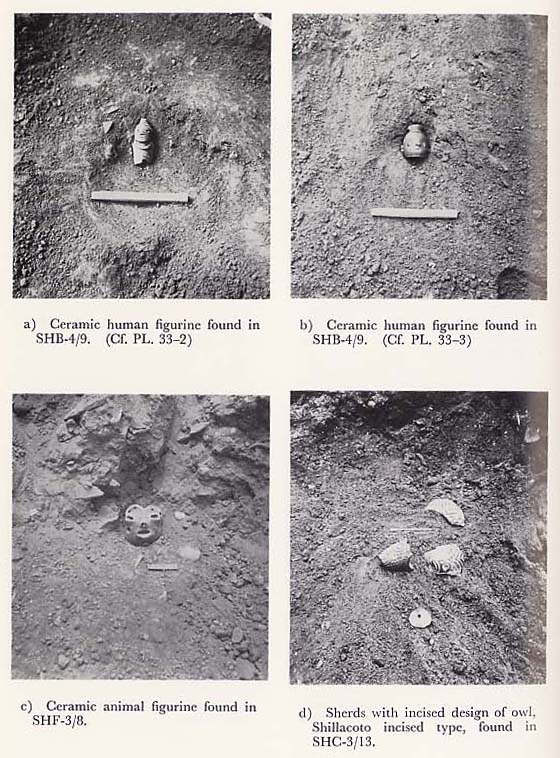
In C-3 zone, walls S-W17 and 18 appeared from a layer under the floor of a structure which stratigraphically was of the Kotosh Period. These walls constituted a small room together with S-W19, which was the southern, wall of the above-mentioned Wairajirca Period construction, and were designated as S-R4. It was later revealed that this room was a tomb, and judging from funeral objects, it was presumed to be a tomb of the Kotosh Period. (See Tomb No. 4). In S-R4, 60 to 70 cm. of the deposite in the upper layer was a dry, coarse-grained, graybrown earth layer containing a relatively large amount of rock fragments. In the lower layer, a deposit of brown clay containing flat stones was noted. Human bones and several funeral objects were discovered from underneath this layer. There were, however, no special burial facilities and corpses were covered directly with clayey soil. To the south of S-W17 appeared the wall S-W21-a curved wall running from east to west parallel to S-W17-and the S-W22, an extension of S-W18. These walls together formed a thick wall with a width of about 1 m. In the upper layer of the wall, there was a large deposit of crumbled wall stones, and when the stones were cleared, remains of a hearth were discovered south-east of S-W21. An ash layer spread around the hearth and from there two ceramic figurines were uncovered. (PL. 22-a, b. see also 33-2, 3.). One of them was the mouth of a bottle.
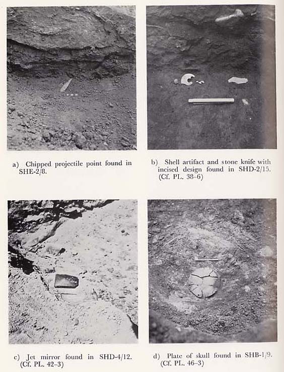
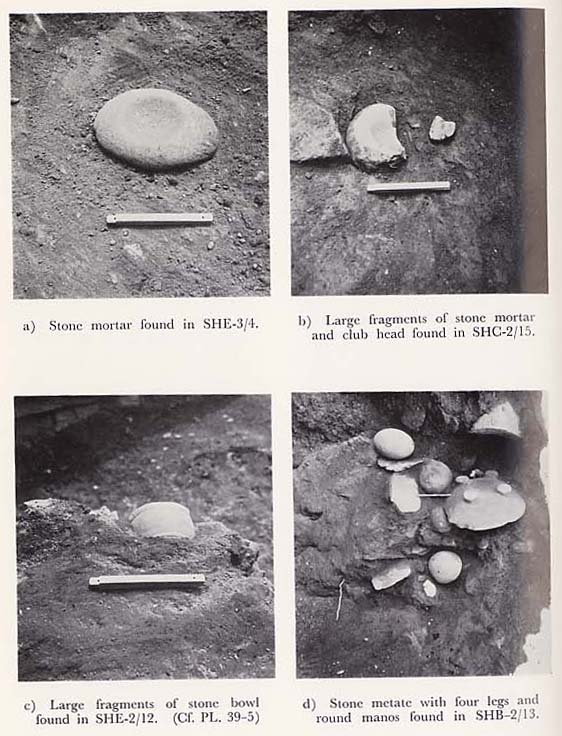
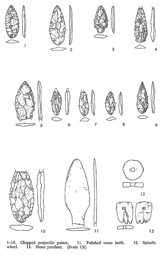
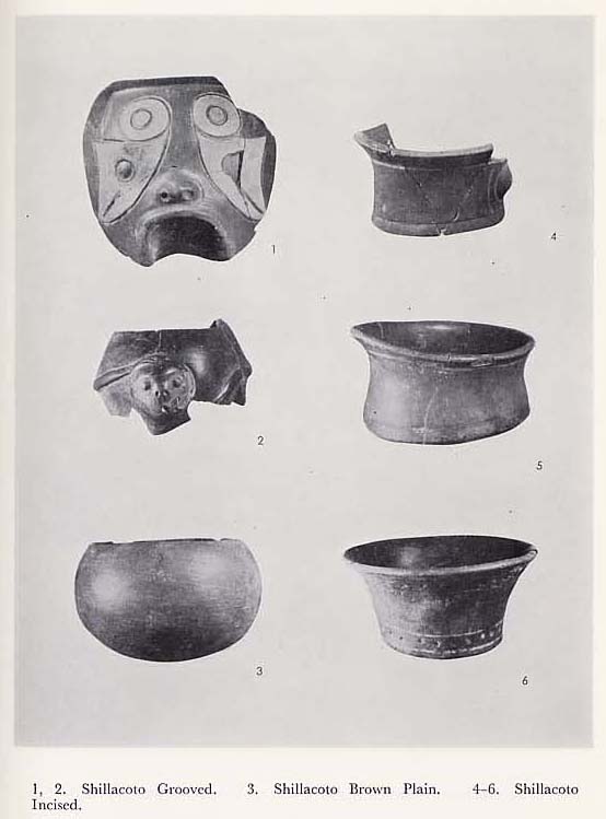
In B zone and C zone, the existing Kotosh Period constructions were removed and excavation below the floor proceeded. Immediately on the western side of S-W12 in B-2 and 3 zones, S-W23-the east wall of the Wairajirca Period structure-appeared from under the Kotosh Period floor. After S-W12 was removed, a layer containing rock fragments appeared to the east of S-W23. This layer contained large amounts of breccia and crushed stones in its upper part, and its soil was a dry, brown sandy soil containing ash. In the lower layer, the rock fragments were smaller and decreased in quantity. The earth burying the rock fragments also changed to black-brown earth containing charcoal. From both of these rock fragment layers, large amounts of earthenware of the Wairajirca Period were unearthed. Polished stone club heads oval or round stone manos, stone metates, stone vessels and various ceramic objects were also discovered there. The stone metate with four legs (PL. 26-d), and a ceramic human figurine (PLs. 33-1 and 49-2), which were found from the lower rock fragment layer, were particularly noteworthy as rare artifacts of the Wairajirca Period. The lower part of the rock fragment layer gradually changed to a black-brown clay layer. On the boundary between B-1 and B-2 zones, the layer below S-W3, 11 and 12 walls changed to a rock fragment layer, and in the upper part of the black-brown soil layer below, club heads, a cylindrical bone object with incisions and a small hole, perhaps a whistle (PL. 45-17) and chipped stone projectile points (PLs. 41-11, 58-10) were found. In C-3 zone, the earth under the Tomb No. 4 floor was black-brown, and yielded a large polished club head (PL. 25-a), figurines with designs of the cat (PL. 33-4) and the owl (PL. 22-d) and other important materials of the Wairajirca Period.
SHD Zone: In D-1 to D-2 zones, an extension of S-W6 appeared upon the removal of S-W2,4 and 5. The floor of S-R 2 was whitish clay soil containing charcoal and coal. It was about 15 cm. thick and compact. Below the floor soil was a coarse-grained brown soil layer containing breccia. From this layer, potsherds of the Wairajirca Period were unearthed in large quantities, and from below S-W5, the wall S-W14-a wall attached later to S-W15-appeared. There was clearly a visible rift between S-W14 and 15 and S-W14 was made of a single row of stones. This wall consisted of 2 or 3 piles of thin, flat stones and with relatively large dressed stones for its foundations. It was about 80 cm. high and its upper level was the same as that of S-W6. In D-3 also, a wall, S-W25, existed in the west of S-W22 in the form of one attached to S-W22. This wall also .resembled S-W14 in structure, being a single row wall made of stone. S-W14 and 25 were the same in level as S-W15 in C-2 zone-the west wall of the Wairajirca Period construction-and S-W18 in C-3 zone. Therefore, it can be presumed that rooms existed in the area surrounded by S-W14, 25 and 20. Here, red-brown soil not containing much stones in the upper layer was deposited. Al-though this did not contain many potsherds or other materials, human bones were found in the lower portion of this layer (Tomb No. 5). Flat stones and small dressed stones had been placed above the bones, but they were disorderly and there were no special burial facilities. The bones included two skulls, thigh bones, etc., which were scattered about. Near the bones, pieces of shoe type earthenware of the Kotosh Period (PLs. 21-b and 28-4, 5) were discovered in complete form. This spot may have been a tomb.
In D-2 and 3 zones, a layer of breccia started immediately below the layer in which human bones were discovered, and the breccia grew smaller in size as we excavated further down, and its quantity also decreased. The soil below the breccia layer turned black-brown, and at point about 1.2 m. from the top surface of S-W15, a stone knife with incised design, a large pendant made of shell (PL. 24-b see also PL. 38-6), ceramic animal figurines, a portion of red pigments, fragments of club heads, etc., were uncovered. Furthermore, from the black-brown layer, a large beautiful fragment of earthenware of the Wairajirca Period, stone bowls, etc., were unearthed. Below the black soil, hard, red-brown clay floor continued.
As stated above, except for some variations in different zones, generally uniform stratigraphical relations were observed in all zones: there was a layer containing breccia below the Kotosh Period layer ; below that was a black-brown layer; and further down was a red-brown clay floor. Stratigraphical relations between different zones will be mentioned in the next chapter. In the current investigation, the construction discovered in most complete form was one composed of the walls S-W6, 15, 19 and 23, which we designated as S-R 6 (PL. 8-a, b). Actually, however, this was not a room but was a magnificent, independent construction resembling an altar or a small platform, which was composed of piles of fine dressed stones and contained a tomb inside. The foundation stones were built on the red-brown clay floor below the black-brown soil. Potsherds and other relics of the Wairajirca Period were found on the red-brown clay floor also.
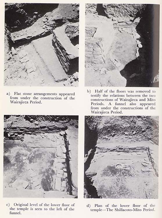
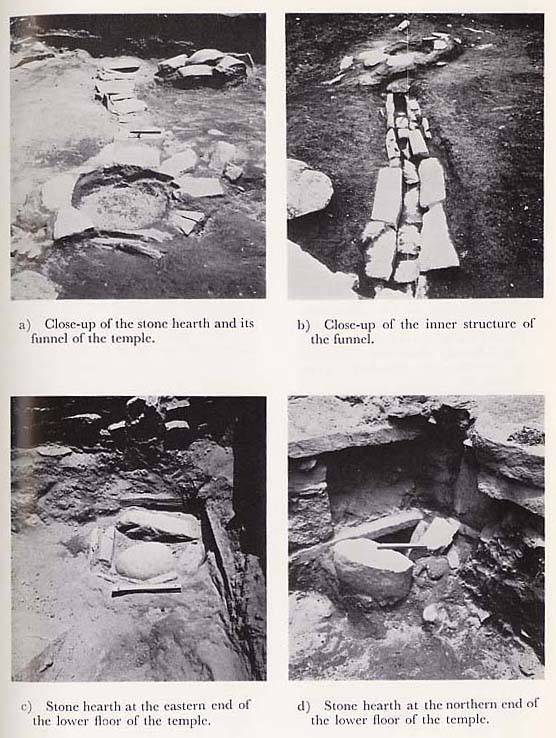
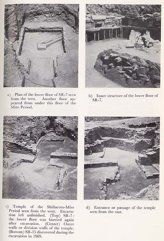
Another construction was one which had been partially revealed from the lower layer of the original B Trench and been presumed to have belonged to the Mito Period. The basic plan of this construction was made clear by the subsequent expansion of the excavation area. Thatis, the construction had twofloors-an upper and lower floor-with a stone hearth in the center of the lower floor. This plan corres ponded basically with the temple in the Mito Period of Kotosh Site. The upper floor surface was discovered under the lowest breccia layer in A- 1, 2, and 3 zones, and in zones 1 and 3 of B, C, and D. It was considerably damaged. On the floor surface, large quantities of Wairajirca potsherds were found which appeared to have been stuck rigidly to the surface. Since the lower floor was presumed to have been related to the red-brown clay floor, we traced the floor surface to examine its relation with the walls around the lower floor (PL. 10). It was disclosed as a result that the red soil floor was built about 10 cm. above the bottom of the wall. Then, a portion of the red-brown clay floor was excavated, leaving a distance of about 1 m. eastward from the base section, to the condition and location of the lower floor more in detail. This revealed that the red clay floor was 10 to 15 cm. thick and that under it was a very hard, chocolate-colored floor. On the surface there were patches of fine-grained yellow-brown coatings of clay applied. The level of this chocolate-colored floor corresponded approximately to the upper part of the foundation stone of the lower floor. In S-W10, the yellow-brown clay coated on the chocolate-colored floor was found heavily stuck to the bottom stones and the wall surface. It was difficult to clearly distinguish the bottom of the red soil floor from the upper surface of the lower chocolate-colored floor. However, judging from the fact that the yellow-brown final coating clay remained between the two floors, it was presumed that the chocolate-colored floor was the lower floor of the Mito Period construction. About 7 cm. below the floor, a row of cover stones for the chimney of the hearth appeared. Later, when S-R6 was removed, a hearth was uncovered from directly below the red-brown clay (PL. 10-d). The soil around the hearth had been burned and turned red over an area of about 2 m. in diameter, with white ash adhered there. From around the hearth as well as from the ash in it, potsherds of the Wairajirca Period were discovered. At the corner where S-W10 and 7 were joined, there was a low, semi-circular platform-like structure. In addition, a stone structure resembling a hearth was also uncovered (PL.11-d). A similar construction was also found in the east corner of S-W10, and along the S-W10 wall, remains of a long pavement (PL. 10-a, b and c)-though it was not exactly known what it was used for-existed under the floor. In D-2 and 3 zones on the west side, the entrance and the outer wall of the temple were uncovered.
As was stated above, the structure in Shillacoto with plans of a temple was found together with potsherds. This made it doubtful whether the construction actually belonged to the Mito Period. Therefore, we made further investigations, excavating the entire lower floor, except the central portion where a hearth was un covered. The lower floor was composed of extremely compact, chocolate-colored clay, containing breccia (PL. 13-b). It was about 50 cm. thick and firm and hard. The soil under this floor did not contain any potsherds or other relics, and under this floor still another yellow-brown floor appeared. A niche-like depression had been found in the lower section of the lower floor wall when B Trench was excavated deep, and some potsherds of the Wairajirca Period had been discovered there. Therefore, the niche-like depression under each wall was closely examined when the floor was further excavated (PL. 12-a, b). In S-W7, flat rocks of micaschist, large-sized natural rocks, rubble, black-brown earth, etc., were packed tightly, and red earth and thick yellow-brown finish coating were also found mixed with them. There were no large rocks under S-W10, and brown clay with some rock fragments was found filled. Under S-W9 of the southern wall, large quantities of small pebbles were seen tightly packed in the black brown soil. When such soil was removed from the niche, thin, flat ashlars, like the base rocks of the upper walls, had been laid. A clean, generally yellow-brown floor was discovered from around the center of the surface (PL. 13-a). It was considered extremely important to clarify the relations between the plan of this floor and the accompanying structure, and the temple discovered in the upper layer. However, in the current investigation, we considered it more important to clarify the entire plan of the temple, and refrained from conducting further excavations.
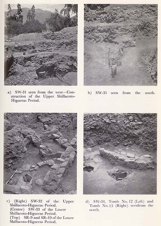
In the investigation in 1969, excavations were carried out to obtain further information on the west entrance and outer walls of the remains of the temple which had been previously discovered. In the excavations, the west side of the excavated site in 1967 was expanded to 9 m. X 12 m. from east to west. Then, it was further divided into smaller zones of 3 m. ×3 m. each, which were designated as SHE-1-4, SHF-1-4, SHG-1-4, etc. A summary of our investigation in 1969 is given below. SHE Zone: Under topsoil, small pebbles were spread over a wide area. In E-1 zone in the north, the pebbles had been deposited about 2 m. deep but the deposit gradually grew thinner-to an average of 60 to 70 cm.-in zones 2 to 4. This layer of small pebbles did not yield very many relics. Potsherds from there, however, were mostly of the Higueras Period. Under the layer of pebbles was a red-brown layer, from which a considerable amount of micaschist and crushed rocks were found. The quantity of potsherds uncovered increased ; the majority of them being from the Higueras Period. In E-5 zone, a polished stone projectile point was recovered from the red-brown layer. In E-3 zone to E-4 zone, the wall S-W31 appeared (PL. 3-a, b). This was about 5.5 m. long, 60 cm. wide and 80 cm. high, and curved in a north-south direction. About 60 cm. away from the southern end of the wall, a monolithic flat dressed stone was erected. There was no wall which could be linked to S-W31. The other walls had presumably been destroyed, and only this one remained. The wall had two surfaces and was a low wall made up of only two or three piles of stones. The upper part of the red-brown layer contained a small quantity of potsherds of the Kotosh Period and the Wairajirca Period. In the layer near the lower floor, about 40 cm. from the S-W31 wall, only potsherds of the Higueras Period were unearthed. The floor of S-W31 spread from D to F zones, with charcoal grains, burned rocks, ash, etc., scattered on it. This floor seemed to have been related to the floor of the upper layer discovered in B-1 and C-1 zones. In E-4, another floor appeared with 20 to 30 cm. of brown soil under the floor of S-W31. On this floor, a round stone structure was found. This consisted of several flat pieces of micaschist laid to form a circle. Its diameter was 60 cm. × 70 cm. and it was filled with fine-grained red-brown clay which contained some soft, small sea shells. About 80 cm. west of this round stone structure, a fragment of a club head was discovered. The red-brown floor referred to before spread over E-5 and D-5 zones, and S-W31 was completely afloat.
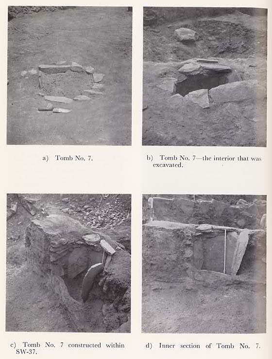
From E-3, 4 to F-4 and 5, S-W33, 34, 35, 36, 37, 38, 39, and 40 were found from the brown soil under the floor and these formed two Higueras Period rooms with a square plan. The one on the south was designated as S-R9 and the one on the north S-R10. S-W36 was a wall common to the two rooms on the west side, and S-W37 was a partition between S-R9 and 10. A Tomb No. 7 (PL. 16) has been made by digging under the S-W37 wall. Deposits within S-R9 consisted of soft, gray-brown soil containing ash, charcoal and vegetable fibers and also had crumbled wall stones and pebbles.
The S-W41 wall was unearthed at the boundary between E-1 and 2 zones. The floor was considerably damaged at this spot and hardly recognizable. In E-2, between S-W40 and 41, the gray-brown soil under the wall was full of rock fragments, and when the rocks were cleared, a thick deposit of ash containing charcoal appeared. This deposit spread over a wide area as far as S-W37 and constituted a layer. From this ash layer, potsherds of the Kotosh Period were uncovered in large quantities. Particularly outstanding was a fragment of pottery with design of a monkey face (PL. 29-1).
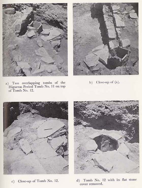
When S-W35, 36, 37, 38, and 39 in E-4 were removed, the walls S-W42, 43, 44, and 45 appeared from underneath. These also constituted a room with a square plan, like the upper ones. But it was evident from the types of potsherds uncovered as well as the stratigraphical relations between the room and other structures that the room was of the Kotosh Period. This room was designated as S-R11. S-W44 and 45 consistituted a double wall. It protruded like a shelf, with the former being on the inside and situated at a lower level than the latter. At the southern end of S-W44 and 45, Tombs Nos. 11 and 12 were found. (PL. 17-a). They had been placed on top of each other, although slightly out of align-ment with each other. Tomb No. 11 had been dug into the S-W44 and 45 walls. Tomb No. 12 was slightly lower in level. The bottom of Tomb No. 11 was of the same level as the stone lid of Tomb No. 12. Both of these were tombs which were used for burials under the floor, in the Higueras Period.
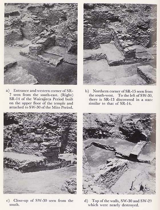
In E-5 zone, when S-W33 was removed and the earth under it was excavated, a brown layer containing pebbles appeared and a considerable amount of potsherds of the Kotosh Period were unearthed from there. From this layer of pebbles, a square hearth surrounded by slabs of micaschist appeared. It was packed tightly with ash. To its south, at a slightly higher level, similar stone arrangements of hearth could be seen. The arrangements of these hearths were inside S-R11, and one of them was situated about 30 cm. above the floor of S-R11. SHG Zone: In G-4 and 5 zones, S-W46, S-W47 and 48 were uncovered. They constituted a room which was designated as S-R12. In S-R12, Tomb No. 15 was discovered beside the S-W47 wall. This tomb was also used for burials under the floor during the Higueras Period. The stone cist had been made by digging the soil, which buried the Kotosh Period construction, and combining several stone slabs. (PL. 19-a, b). Under the floor of S-R12, there was a thick layer of pebbles. This was a pebble layer leading to an ash layer which contained large quantities of potsherds of the Kotosh Period. This layer continued to the upper floor of the Mito Period construction and yielded Wairajirca potsherds and stone objects as well as various other artifacts. The upper layer contained large amounts of breccia and the lower layer had boulders. We removed S-W40 and S-W41 from E-2 and E-3. Digging the ash layer further down, we found another layer of white ash beneath the 10 cm. deep brown earth. The newly discovered ash layer spread under the entire area of the S-R10 floor; it contained a number of pieces of earthenware of the Kotosh Period. Over the area of D, E-1 and E-2, the top section of S-W30, the outer wall of the Mito Period, was unearthed from the ash layer beneath the structure of the Kotosh Period. S-W30 extends in a north-westerly direction from the boundary of E and D-1 and it was impossible for us to estimate the whole scale of the wall from the limited findings from the trenches. We therefore extended each section of D, E, and F further in order to study the outer wall. In the vicinity of the entrance, the upper sections of the wall stones were considerably damaged, while the wall was fairly in good condition in E and D-1; S-W30 remained intact up to a height of about 2 m. from the upper floor level. The uppermost face of S-W30 stretched to north-west for about 8 m., but the original wall ended at a point about 6 m. from the entrance and from there to the north, there were traces of another wall attached to it as a continuation (PL. 14-c). At this spot, on the upper floor, we found a stone structure quite similar to S-R6 (PL. 14-b), which was a tomb of the Wairajirca Period ; and also inside the temple, on the upper floor, there was a stone structure, something like a small platform, constructed as if adjoining S-W30 (PL. 14-a). The upper half of these structures was buried in the layers of ash and small rock fragments containing the ceramic sherds of the Kotosh and Wairajirca Periods, while the lower half was buried in a breccia layer, out of which only the Wairajirca Period materials were unearthed. Ceramic sherds were also unearthed from the upper floor and the passage of the temple.
On the other hand, in E as well as D-3, D-4, and D-5, we proceeded with the excavation of S-W29, another wall of the temple. Removing S-W42, S-W43, and S-W44, which are the walls of S-R11, we reached down to an ash layer that contained plenty of pebbles. There we found pieces of earthenware of the Kotosh and the Wairajirca Periods. Immediately beneath the mentioned ash layer was a breccia layer, from which a bottle of the black polished type was found (PL. 30-1). On the upper layer to the west of S-W29, which is the outer wall of the temple, S-W43 was constructed parallel to S-W29. We found the breccia layer mentioned before lying underneath S-W43, and S-W29 was buried in this layer. From the entrance to E-4, the upper wall was considerably damaged ; only those parts 50 to 60 cm. above the upper floor remained intact. The upper part was damaged also in E-5, and we could not discover another wall connected to it. In E, D-3 and D-4, a breccia layer filled the temple up to the floor level. Ceramic wares were unearthed in this layer also.
D, E-2 and E-3 mainly correspond to the temple entrance. The major part of D zone had already been excavated during our researches in 1967. There fore, the main objective of our excavation in 1969 was to survey the outer wall of the temple as well as the area just outside the temple entrance. As regards the entrance area, after digging down from the floor level of S-R10, previously described, we encountered a layer of the Kotosh Period. However there was no structure found in this particular area, but instead, a deeper layer of rubble continued down to the lower floor, i.e., the passage of the temple. In the case of E-2 and E-3, the rubble layer reached as far down as the lower floor, and there was neither a dark brown earth layer nor a reddish-brown clay bed like those found in A, B, C, and D zones. The entrance was about 3 m. in width. The outer wall of the temple was about 1.2 m. in thickness; there was an upper floor face uncovered also on the west side of the outer wall, showing that there used to be another temple standing on the west side. The entrance must have been a passage connecting those two structures on the east and the west; and what was considered to be an outer wall must have been a partition wall separating the two temples. However, the upper floor on the west side is narrower than that on the east side. The construction of the wall that connects the lower floor with the upper floor is somewhat different from that of the outer wall. S-W27 and S-W28, passage walls at the eastern entrance, pass under the outer wall to reach the wall of the western upper floor. We closely followed the wall in an endeavor to obtain the western upper floor plan, but we were unable to discover its definite plan. On the northern side, the upper floor face continued along S-W30, and there appeared a small platform like structure on the floor of the extended section. of E-1 as we have already mentioned. On the southern side, the upper floor continued for about 1.5 m. before turning to the west, but there was no more continuation of wall stones; we discovered at several spots those stones which could have been the foundations of a low wall. We connected those spots but could not obtain a definite plan of the wall in question. Consequently, we could not estimate what type of structure had been constructed on the west side or whether only the upper floor had been constructed along the outer wall. |